Augrabies Falls National Park
You hear Augrabies before you see it. The Khoikhoi people named the waterfall Ankoerebis -- "the place of big noises" -- and when the Orange River runs high, the roar carries across the arid scrubland for kilometers. The Trekboers who settled the region later softened the name to Augrabies, but the noise remains unchanged. Since 1966, an 820-square-kilometer national park has wrapped around the falls and the granite gorge that swallows them.
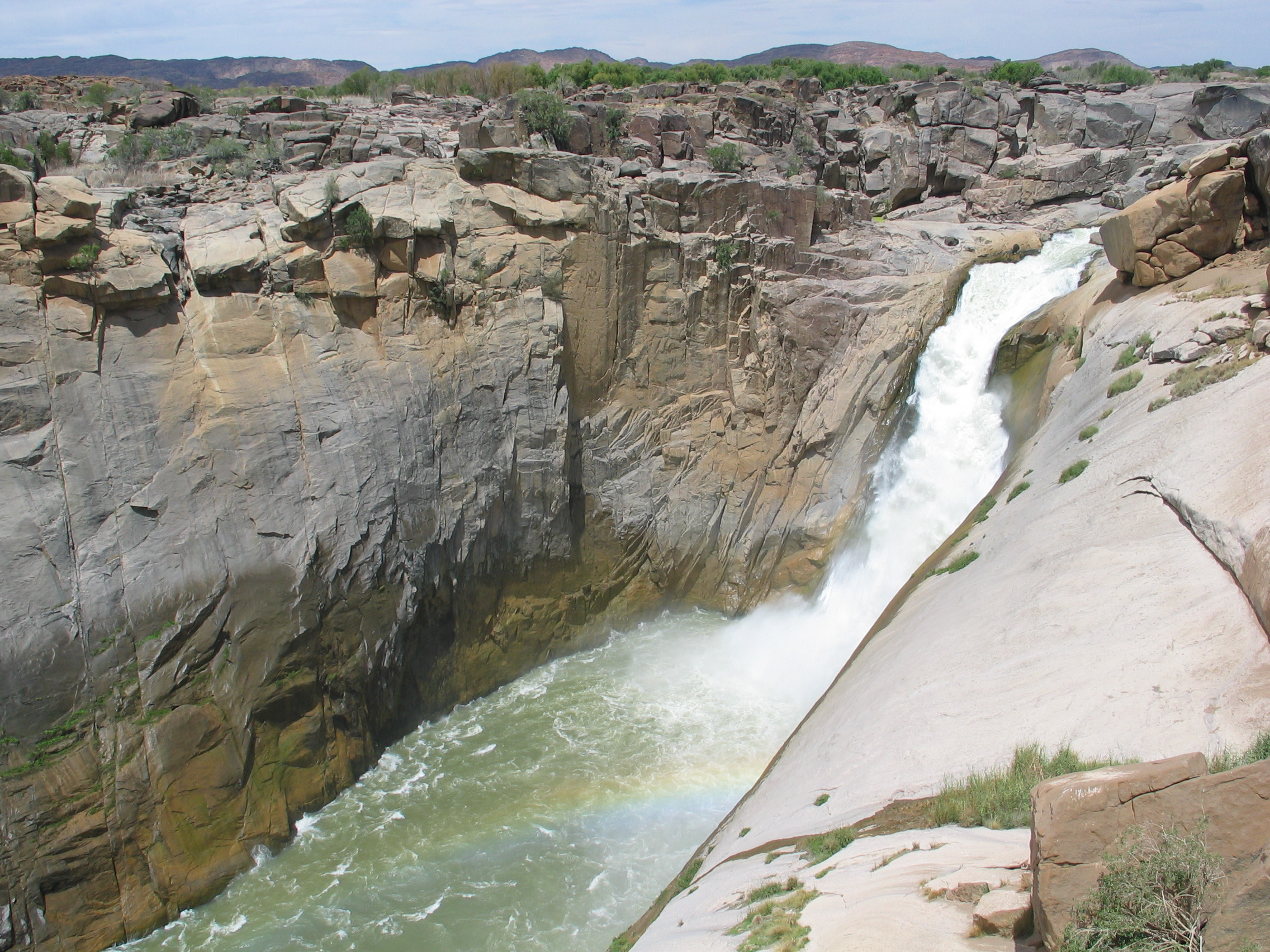
Water Through Stone
The Orange River is South Africa's largest, and at Augrabies it funnels through a narrow granite channel before dropping roughly 60 meters into a gorge that averages 240 meters deep and runs for 18 kilometers. The gorge is an exhibition of what water can do to rock given enough time: smooth curves worn into granite, walls polished to a dark sheen, boulders rounded into abstract sculptures by millennia of floods. When the river is in full flood, the spectacle is genuinely awe-inspiring -- a curtain of brown water thundering into the chasm, spray rising high enough to create its own weather. During the dry season, the falls thin to a more modest cascade, revealing the rock architecture that the floods normally conceal.
Quiver Trees and Clever Baboons
The park's most characteristic plant is the quiver tree, a giant aloe known locally as kokerboom. Growing up to five meters tall, these slow-growing succulents are perfectly adapted to the Nama-Karoo's extremes -- scorching heat, infertile soil, and water that arrives in violent bursts and then vanishes for months. The San people once hollowed out the tree's soft branches to make quivers for their arrows, giving the species both its common name and an enduring image: the spiky silhouette against a sunset sky that appears on every Northern Cape tourism brochure. When the trees flower in winter, their nectar draws flocks of birds, and baboons can be seen tearing the blossoms apart to drink the sweet liquid inside.
Living on the Edge
The park supports an unexpectedly rich animal population for such arid terrain. Giraffe browse the scattered thornveld. Leopards hunt along the gorge rim, using the broken rock for cover. Eland, kudu, and steenbok pick through the scrub, and rock hyraxes -- dassies -- sun themselves on boulders with the supreme indifference of animals that have never needed to hurry. The park claims an exceptionally high concentration of lizards, their diversity driven by the mosaic of microhabitats the rocky terrain provides. Vervet monkeys and baboons have become thoroughly habituated to humans and will steal any food left unattended, making camp management a daily negotiation between species.
Moon Rock and the Klipspringer Trail
A prominent landmark within the park is Moon Rock, a massive exfoliation dome measuring roughly 700 meters long, 100 meters wide, and 30 meters high -- a whale-back of bare granite that catches the light differently at every hour. The park offers several short hiking trails and a three-day Klipspringer trail that traces the gorge rim, though this route closes in summer when temperatures push past 36 degrees Celsius and the exposed rock becomes dangerous. For those who prefer their drama without the exertion, walkways lead from the main camp restaurant to observation decks at the falls, which are illuminated until 10 p.m. for a cooler nighttime viewing experience.
Heat, Hazards, and the Road In
Augrabies is not a park that coddles visitors. Summer temperatures regularly exceed 36 degrees, making many walks inadvisable and camping genuinely uncomfortable without preparation. The park lies about 120 kilometers west of Upington, reachable either by a long drive from Cape Town via the N7 and R358 or by flying into Upington Airport and driving the final stretch. Once inside, the risks are wild rather than human: scorpions and snakes require caution on walks, and the baboons demand respect for any food supply. The park falls within a marginal malaria zone, though the risk is low enough that most visitors skip prophylactics. What draws people here is the gorge, the falls, and the stark beauty of a landscape that is precisely as inhospitable as it is magnificent.
From the Air
Located at 28.59S, 20.34E in the Northern Cape, South Africa. The Orange River gorge and waterfall are visible from altitude as a dark cleft cutting through otherwise flat terrain. The park covers 820 square kilometers. Nearest major airport is Upington (FAUP), approximately 120 km to the east. From the air, look for the dark line of the Orange River cutting through pale Karoo scrub, then follow it to where the gorge deepens dramatically at the falls.