Auyan-tepui
Seen from the air, Auyan-tepui looks less like a mountain and more like a misplaced continent. Its summit stretches across 667 square kilometers of rock, roughly the area of a mid-sized city, yet it rises in sheer cliffs from the surrounding jungle. The Pemon people named it 'House of the Gods,' and from certain angles the description feels literal -- a vast stone platform suspended between earth and sky, perpetually wreathed in cloud.
A Mountain Measured in Kingdoms
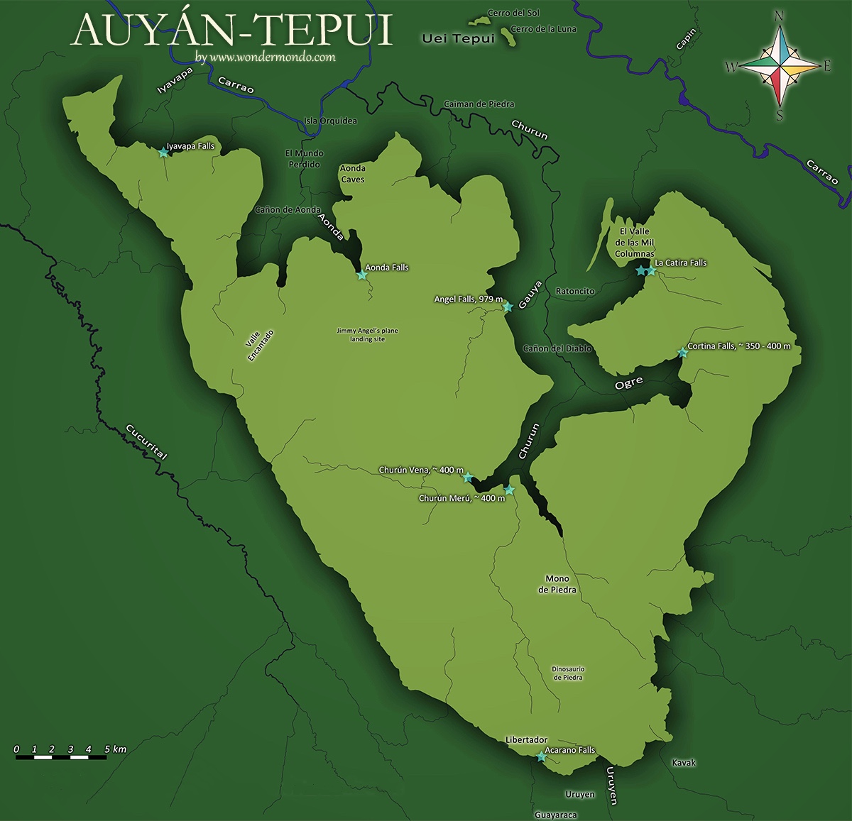
Auyan-tepui is the most visited and one of the largest tepuys in the Guiana Highlands, though not the tallest. Its summit area of 666.9 square kilometers, combined with an estimated slope area of 715 square kilometers, makes the massif enormous by any standard. The broader Auyan Massif includes the satellite peaks of Cerro El Sol and Cerro La Luna to the north and Uaipan-tepui to the south, bringing the total summit footprint to roughly 670 square kilometers. At this scale, the tepuy is not a single feature but an ecosystem unto itself -- a world above the world, where altitude and isolation have produced biological communities that exist nowhere else on the planet.
An Evolutionary Laboratory in the Clouds
Around 25 species of amphibians and reptiles are known from the summit plateau, along with numerous bird species and a rich assemblage of flora. One researcher in the 1960s called it 'the home of fifty million orchids,' a characterization that captures the botanical abundance if not the precise count. Because the tepuy's cliffs form an effective barrier to migration, species on the summit have evolved in isolation over millions of years, producing endemic frogs, insects, and plants found on no other mountain. The summit's sinkholes -- some hundreds of meters wide and deep -- create further pockets of isolation. Each sinkhole is its own miniature island, a habitat within a habitat, where evolution runs parallel experiments just kilometers apart.
The Crash That Made a Waterfall Famous
Auyan-tepui achieved international fame not for its biology but for an accident. In 1933, American bush pilot Jimmie Angel was searching for gold ore when he flew over the tepuy and spotted a waterfall of staggering height cascading from its cliffs -- what would become Angel Falls, at 979 meters the world's tallest uninterrupted waterfall. The drop is nineteen times higher than Niagara Falls. In 1937, Angel returned and attempted to land his Flamingo monoplane on the heart-shaped mesa. The wheels sank into marshy ground, and Angel, his wife Marie, and two companions were forced to hike down the gradually sloping backside. The trek took eleven days. His plane remained on the summit for 33 years before being retrieved by helicopter and eventually restored to its current home outside the airport in Ciudad Bolivar.
Rock Older Than Complex Life
The sandstone and quartzite that form Auyan-tepui belong to the Roraima Group, a sequence of sedimentary rocks laid down roughly 1.5 to 1.9 billion years ago atop the even older Guiana Shield. This is rock from before multicellular life existed -- before fish, before fungi, before anything more complicated than single-celled organisms. The erosion patterns that created the tepuys' distinctive vertical cliffs and flat summits have been working for hundreds of millions of years, carving cave systems within the quartzite that are among the most unusual on Earth. The Aonda Cave system inside Auyan-tepui has been studied for its silica geochemistry, revealing how water dissolves quartzite over geological timescales that make human history look like a blink.
Approaching the House of the Gods
Most visitors to Auyan-tepui arrive by small plane to Canaima, the village on the northwest edge of the national park, and then travel upriver to view Angel Falls from below. Fewer attempt the summit. The first university expedition reached the plateau in 1956, and scientific teams have returned periodically to catalog the unique flora and fauna. From the air, the tepuy is unmistakable: a dark, flat-topped mass rising abruptly from green lowlands, its cliffs streaked with waterfalls after rain. Clouds often obscure the summit, parting unpredictably to reveal glimpses of the plateau's strange terrain -- rock gardens, peat bogs, and sinkholes that look, from altitude, like the dimples on an enormous stone golf ball.
From the Air
Located at 5.90N, 62.55W in Canaima National Park, Venezuela. Auyan-tepui is the most prominent terrain feature in the region -- a massive flat-topped mesa visible from well over 100 nautical miles in clear conditions. Angel Falls is on the northwest face. The summit plateau at approximately 2,000 meters is often cloud-covered. Nearest airport: Canaima (SVCN). Maintain safe altitude and be aware of mountain wave turbulence and convective weather, especially in afternoon. The heart-shaped outline of the summit is distinctive from above 10,000 feet AGL.