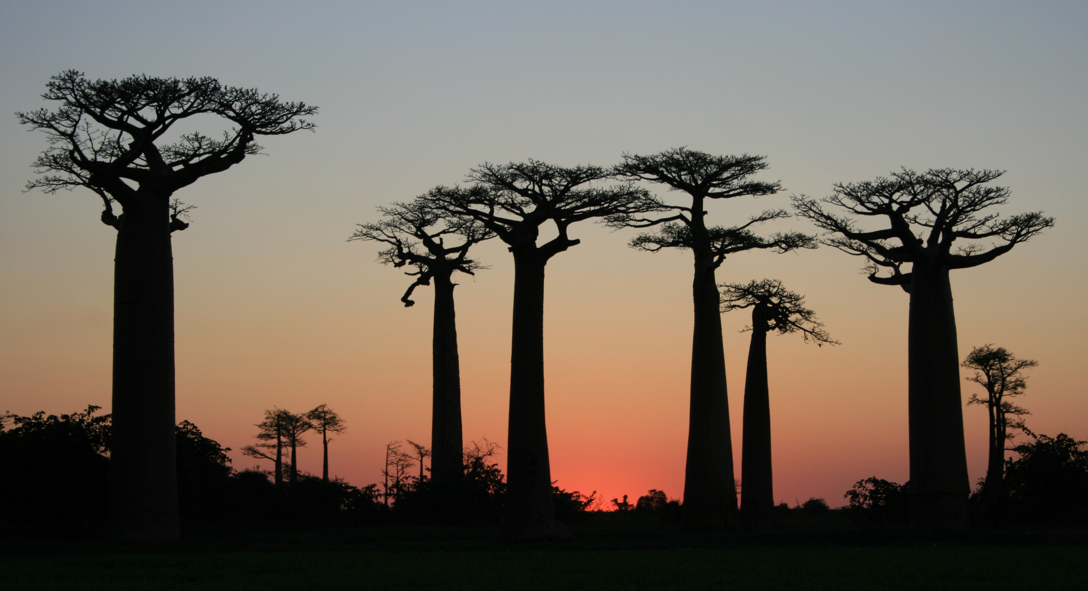
Avenue of the Baobabs
They were never planted in a row. The roughly two dozen Grandidier's baobabs that line a 260-meter stretch of unpaved road between Morondava and Belon'i Tsiribihina did not grow up in isolation, towering over scrub and rice paddies as they do today. They grew in dense tropical forest, surrounded by thousands of other trees. The forest was cleared. The baobabs remained -- too useful, too sacred, or simply too massive to cut down. What travelers now photograph at sunset as one of Madagascar's most recognizable landscapes is, in a sense, a ghost forest: the survivors standing where an ecosystem used to be.
Mothers of the Forest
The Malagasy call baobabs renala or reniala, meaning "mother of the forest." The species here, Adansonia grandidieri, is endemic to Madagascar and grows up to 30 meters tall, with massive smooth trunks that can reach several meters in diameter. Along the main avenue, 20 to 25 trees line the road itself, with an additional 25 or so scattered across nearby rice paddies and meadows within about four hectares. Their canopies spread wide above the flat terrain, and in the golden light of late afternoon, their trunks glow a warm reddish-brown. The trees are old -- centuries old, by most estimates -- though exact dating is difficult because baobabs do not produce reliable annual growth rings. They predate the road, the paddies, and the villages around them. They are remnants of a world that no longer exists in this part of Madagascar.
A Love Story in Twisted Wood
Near the main avenue, two baobabs have grown intertwined, their trunks spiraling around each other as they reach skyward. Locals call them les baobabs amoureux -- the baobabs in love. According to legend, a young man and woman from a nearby village fell in love but were already promised to others. Unable to marry, they asked their god for help. The two baobabs grew from the earth, entwined for eternity as the couple had wished to be. The story is told to every visitor, and the intertwined trees have become a secondary attraction on the road from Morondava. Whether one believes the legend or prefers the botanical explanation -- baobabs sometimes fuse when growing in close proximity -- the image is striking either way: two massive organisms locked together in what looks very much like an embrace.
What the Forest Lost
Madagascar's western dry forests have been retreating for centuries as human populations grew and agriculture expanded. The baobabs survived the clearing because they provided food, building material, and shade -- and because cutting down a tree that thick requires enormous effort. But survival is not the same as thriving. The Avenue of the Baobabs faces ongoing threats from effluents draining off the encroaching rice paddies, from bushfires and forest fires that damage root systems, and from the slow squeeze of development around the trees' bases. Without the surrounding forest to regulate moisture, seed dispersal, and pollination, the baobabs stand as individuals rather than members of a reproducing community. Young baobabs are scarce along the avenue. The giants are holding on, but they are not being replaced.
Protection, Slowly
In July 2007, Madagascar's Ministry of Environment, Water and Forestry granted the avenue temporary protected status -- a step toward making it the country's first natural monument. Full protection as a natural monument followed in July 2015. Yet even with legal status, practical challenges remain. There is no visitor center, no gate fee, and local residents see little direct income from the travelers who arrive by the busload at sunset, snap photographs, and leave. Since 2014, the Malagasy conservation organization Fanamby has been working on an ecotourism project to channel tourism revenue toward both conservation and the local economy. Infrastructure to support the initiative was inaugurated in 2018. The goal is to ensure that the communities living alongside the baobabs benefit from the attention the trees attract -- a step that took more than a decade of international fame to achieve.
From the Air
Located at 20.25S, 44.42E along unpaved Route Nationale 8 in western Madagascar. From altitude, the avenue is difficult to spot directly, but the surrounding landscape is distinctive: flat agricultural land, rice paddies glinting with water during the wet season, and the brown unpaved road running roughly north-south. Morondava airport (FMNR) is the nearest airstrip, approximately 20 km to the southwest. The Tsiribihina River is visible to the north. The coastline of the Mozambique Channel lies to the west. Best viewed in late afternoon light when the baobabs cast long shadows across the road.