Babak Fort: The Last Stronghold of Rebellion
For twenty years, the most powerful empire on Earth could not take a castle built on a mountain in northwestern Iran. Babak Khorramdin, leader of the Khurramite rebellion, used this fortress at the edge of the Arasbaran forests as his headquarters while waging a guerrilla war against the Abbasid Caliphate. The citadel sits between 2,300 and 2,600 meters above sea level, accessible only through a narrow passageway and a 200-meter corridor carved through rock. Ice and snow guarded it in winter. Steep cliffs guarded it the rest of the year. The Abbasids needed siege machinery, naphtha-throwers, and one of their finest generals to finally breach it in 837 AD.
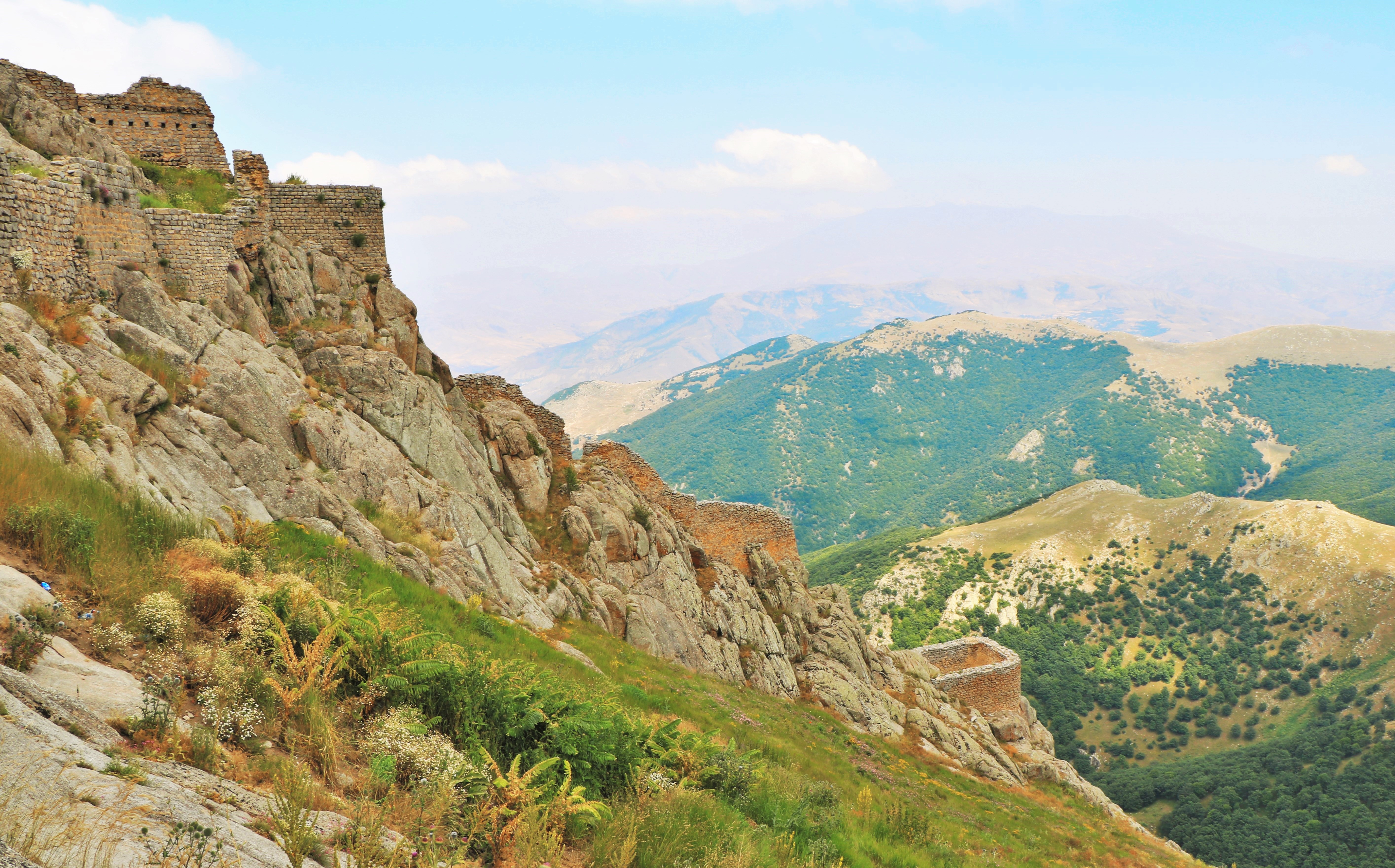
A Fortress Born of Geography
Babak Fort occupies two peaks in the mountains southwest of Kalibar City in East Azerbaijan province, roughly 50 kilometers from Ahar. The Arasbaran oak forest blankets the surrounding slopes, and jagged cliffs fall away on all sides. From the castle walls, the view stretches across mountains that fade into the distance like stacked waves. The approach alone was a defensive weapon. Attackers had to navigate dense forest, climb steep terrain, and squeeze through a narrow passageway before reaching the main fortifications. The castle dates to the Sasanian era, possibly as early as the 3rd century BC under the Parthians, long before Babak Khorramdin made it famous. By the time he claimed it, the fortress had already endured centuries of mountain weather and mountain warfare.
The Khurramite Rebellion
The Khurramites were a movement rooted in pre-Islamic Iranian traditions, resisting the Arab-Islamic caliphate that had conquered Persia. In Azerbaijan, the movement split between two factions. One was led by Abu Imran, the other by a landlord named Javidhan, who kept his headquarters at the fortress of Badd -- the place now known as Babak Fort. Around 816, the two factions clashed. Abu Imran died in the fighting. Javidhan was mortally wounded and survived only three days. His apprentice, Babak Khorramdin, inherited both the leadership and Javidhan's widow. Babak proved a formidable commander. He turned the Arasbaran mountains into a theater of asymmetric warfare, using the terrain to neutralize the Caliphate's advantages in manpower and resources. The rebellion persisted for roughly two decades, a persistent thorn in the side of the Abbasid state.
The Fall of Badd
The Abbasid caliph al-Mu'tasim finally dispatched his general Afshin to end the rebellion. Afshin established a camp six miles from the fortress and received reinforcements under the Arab commander Abu Dolaf. Rather than attempt a frontal assault up the mountain, Afshin launched a methodical campaign of mountain attacks, probing the fortress defenses. He brought siege machinery and naphtha-throwers -- an early incendiary weapon -- to bear against the walls. The combination eventually broke the Khurramite defenses in 837. Babak escaped the fortress as it fell but was captured shortly afterward. His execution was a public spectacle designed to demonstrate the Caliphate's authority. The fortress of Badd, which had defied an empire, was left in ruins.
What the Ruins Remember
Today the site is known locally as Qal'a-ye Jomhur, sitting on the left branch of the Qarasu River. A castle and a palace remain atop the mountain, weathered but still standing against the sky. The ruins have become a symbol of resistance in Iranian culture, particularly in Azerbaijan province, where Babak Khorramdin is remembered as a folk hero who fought to preserve Iranian identity against foreign domination. Visitors who make the steep climb find not just stone walls but a landscape that explains the history. Standing at the summit, looking out across the Arasbaran forests, you understand why an empire needed twenty years and its best general to conquer this place. The mountain itself was the strongest fortification.
From the Air
Located at 38.84°N, 46.98°E in the mountains of East Azerbaijan province, northwestern Iran. The fortress sits at 2,300-2,600 meters elevation amid the dense Arasbaran forests. From altitude, look for the mountain ridge southwest of Kalibar City, roughly 50 km from Ahar. The nearest significant airport is Tabriz International Airport (OITT), approximately 150 km to the southwest. The Aras River valley is visible to the north, marking the Iran-Azerbaijan border. Clear weather offers views of layered mountain ridges covered in oak forest.