The White River Badlands of South Dakota consist of a scenic landscape of differentially weathered and eroded, nonmarine sedimentary rocks of Tertiary age.  The most visually-striking areas have been set aside as an American national park (Badlands).
The simplified stratigraphic succession in Badlands National Park is:
Sharps Formation (Oligocene)
Brule Formation (Oligocene)
Chadron Formation (Eocene)
Chamberlain Pass Formation (Eocene)
Fox Hills Formation (Cretaceous-Paleocene?)
Pierre Shale (Cretaceous)
The Brule and Chadron Formations make up the White River Group, which along with the overlying Sharps Formation, are the principal scenery-making units in the White River Badlands.  Light-colored volcanic ash beds are present in the succession, as are numerous reddish-colored paleosol ("fossil soil") horizons.  The Pierre Shale at the base of the exposed succession is a marine unit.
The White River Group weathers and erodes relatively quickly into a rugged landscape with steep slopes, little to no soil, and little to no vegetation.  These are the characteristics of badlands topography - "bad" referring to its unsuitability for farming.
Nonmarine fossils are relatively common in the White River Group - principally fossil mammals and other vertebrates.  Fossils in the Chadron Formation indicate a swampy, near-sea level environment.  The overling Brule Formation produces fossils consistent with a grassy prairie environment.  The transition from low-elevation swamp to higher-elevation prairie in this area coincides with the uplift of the Rocky Mountains during the late stages of the Laramide Orogeny.
Erosion rates in the White River Badlands indicate that the landscape started to appear about half-a-million years ago and will disappear about half-a-million years from now.  The landscape has about a one million year lifespan.
The hills seen here have two distinctive paleosol horizons.  The lower, thicker, yellowish-colored interval is the Yellow Mounds Paleosol, a Late Eocene ultisol.  The upper, thinner, reddish-colored interval is the Interior Paleosol, a Late Eocene alfisol.  The overlying rocks are the Upper Eocene Chadron Formation.
Stratigraphy: Yellow Mounds Paleosol (capping the Fox Hills Formation) and Interior Paleosol (capping the Chamberlain Pass Formation), basal White River Group, Chadronian Stage, Upper Eocene
Locality: Yellow Mounds Overlook area, White River Badlands, Badlands National Park, western South Dakota, USA


Online pub. covering the geology of Badlands National Park:

pubs.usgs.gov/of/2003/0035/pdf/of03-35.pdf
The White River Badlands of South Dakota consist of a scenic landscape of differentially weathered and eroded, nonmarine sedimentary rocks of Tertiary age. The most visually-striking areas have been set aside as an American national park (Badlands). The simplified stratigraphic succession in Badlands National Park is: Sharps Formation (Oligocene) Brule Formation (Oligocene) Chadron Formation (Eocene) Chamberlain Pass Formation (Eocene) Fox Hills Formation (Cretaceous-Paleocene?) Pierre Shale (Cretaceous) The Brule and Chadron Formations make up the White River Group, which along with the overlying Sharps Formation, are the principal scenery-making units in the White River Badlands. Light-colored volcanic ash beds are present in the succession, as are numerous reddish-colored paleosol ("fossil soil") horizons. The Pierre Shale at the base of the exposed succession is a marine unit. The White River Group weathers and erodes relatively quickly into a rugged landscape with steep slopes, little to no soil, and little to no vegetation. These are the characteristics of badlands topography - "bad" referring to its unsuitability for farming. Nonmarine fossils are relatively common in the White River Group - principally fossil mammals and other vertebrates. Fossils in the Chadron Formation indicate a swampy, near-sea level environment. The overling Brule Formation produces fossils consistent with a grassy prairie environment. The transition from low-elevation swamp to higher-elevation prairie in this area coincides with the uplift of the Rocky Mountains during the late stages of the Laramide Orogeny. Erosion rates in the White River Badlands indicate that the landscape started to appear about half-a-million years ago and will disappear about half-a-million years from now. The landscape has about a one million year lifespan. The hills seen here have two distinctive paleosol horizons. The lower, thicker, yellowish-colored interval is the Yellow Mounds Paleosol, a Late Eocene ultisol. The upper, thinner, reddish-colored interval is the Interior Paleosol, a Late Eocene alfisol. The overlying rocks are the Upper Eocene Chadron Formation. Stratigraphy: Yellow Mounds Paleosol (capping the Fox Hills Formation) and Interior Paleosol (capping the Chamberlain Pass Formation), basal White River Group, Chadronian Stage, Upper Eocene Locality: Yellow Mounds Overlook area, White River Badlands, Badlands National Park, western South Dakota, USA Online pub. covering the geology of Badlands National Park: pubs.usgs.gov/of/2003/0035/pdf/of03-35.pdf

Badlands: The Land Too Poor to Farm, Too Beautiful to Ignore

south-dakotabadlandsfossilsgeologyprairie
5 min read

The Lakota called it 'mako sica' - land bad. French trappers translated this as 'les mauvaises terres à traverser' - bad lands to travel across. The name stuck because the name fits. The Badlands of South Dakota are a maze of steep canyons, knife-edge ridges, and eroded spires that defeated horses and wagons. But what made the land bad for travel made it extraordinary for science. The erosion that created impassable terrain also exposed 75 million years of geological history - ancient seabeds, subtropical forests, the skeletons of creatures that haven't walked the earth for millions of years. The land that defeated travelers rewards anyone willing to walk it slowly, reading stories written in stone.
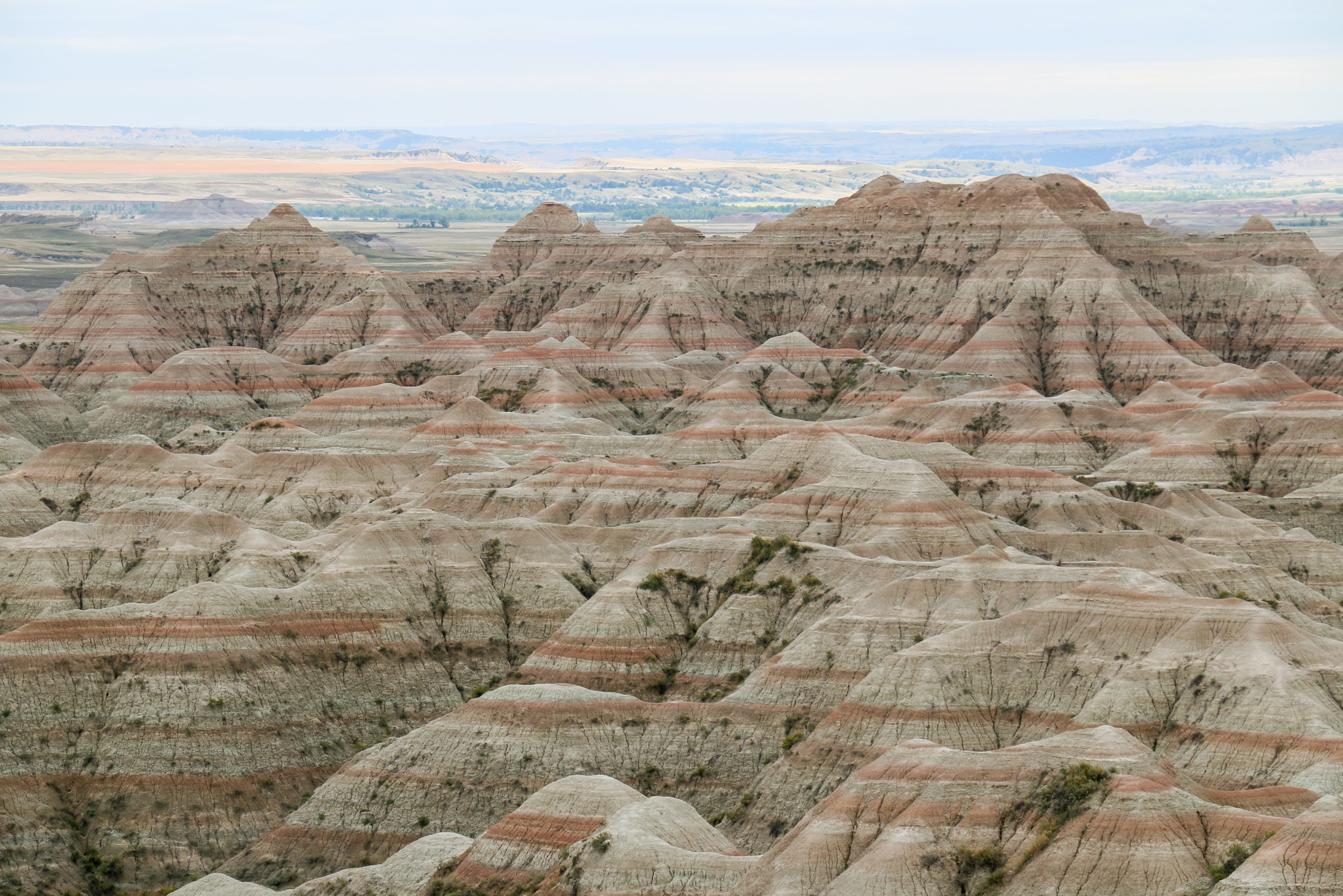
The Geology

The Badlands formations record three distinct environments. The oldest layers, the Pierre Shale, formed 75-69 million years ago beneath an inland sea that split North America in two. Above this, the Chadron Formation documents a subtropical forest of 37-34 million years ago. The Brule Formation on top records the cooling and drying that replaced forests with grassland 34-30 million years ago. Erosion carved these layers into the landscape visible today - a process ongoing as rain and wind remove half an inch per year. The formations that seem permanent are actively disappearing; the badlands will eventually erode to prairie. What we see is a geological moment.

The Fossils

The Badlands are one of the world's richest fossil beds. The formations contain ancient horses the size of dogs, giant pig-like creatures called entelodonts, saber-toothed cats, and countless species that left no modern descendants. The first scientific fossils were collected in the 1840s; collecting continues today. The erosion that makes the terrain difficult also continuously exposes new specimens - fossils emerge from the rock as surrounding material washes away. The park protects the fossils legally; trained paleontologists conduct authorized excavations. Visitors occasionally spot exposed bones; they're required to leave them in place and report discoveries. The landscape is literally surfacing its buried past.

The Prairie

Beyond the eroded formations, the Badlands preserve some of North America's largest remaining mixed-grass prairie. Bison, reintroduced after near-extinction, roam the grasslands. Pronghorn antelope - the fastest land animal in the Western Hemisphere - share the range. Prairie dogs build extensive underground cities; black-footed ferrets, once thought extinct, hunt them. The prairie ecosystem, nearly eliminated by agriculture, survives here in something approaching its original form. The badlands that prevented farming preserved what farming destroyed elsewhere. The land too poor to cultivate became refuge for a landscape that once covered the continental interior.

The History

The Badlands saw violence as well as erosion. The Lakota considered the land sacred and haunted. In 1890, the Ghost Dance movement swept through the Lakota reservations; the massacre at Wounded Knee, just south of the present park, killed at least 250 Lakota. The Stronghold Table within the park was a Ghost Dance site. The land carries these histories alongside its geological ones. Today, the Oglala Lakota co-manage the South Unit of the park, working to integrate Indigenous perspectives with conventional interpretation. The badlands are not just fossils and formations but layers of human experience deposited over millennia.

Visiting Badlands

Badlands National Park is located in southwestern South Dakota, approximately 50 miles east of Rapid City via Interstate 90. The Badlands Loop Road (Highway 240) traverses the North Unit, with numerous overlooks and short trails. The Ben Reifel Visitor Center provides orientation. The Door, Window, and Notch trails offer accessible formation exploration. Backcountry hiking is permitted throughout; no trails exist, but navigating the terrain is part of the experience. Camping is available at Cedar Pass. Summer is busiest; spring and fall offer comfortable temperatures and smaller crowds. The park rewards multiple visits at different times of day - the colors shift dramatically with changing light. Allow at least half a day; the scale deserves more.

From the Air

Located at 43.75°N, 102.50°W on the northern Great Plains of South Dakota. From altitude, the Badlands appear as a dramatic wall of eroded terrain rising from surrounding prairie - the contrast between flat grassland and tortured formations is striking. The formations display visible striping where different geological layers have eroded at different rates. The White River traces the formations' southern edge. The Loop Road is visible winding through the North Unit. The Pine Ridge Indian Reservation occupies the South Unit and surrounding area. The Black Hills rise to the west. From altitude, the Badlands look like a wound in the prairie - the earth's interior exposed, layers of deep time visible in a landscape that appears almost Martian against the green plains.