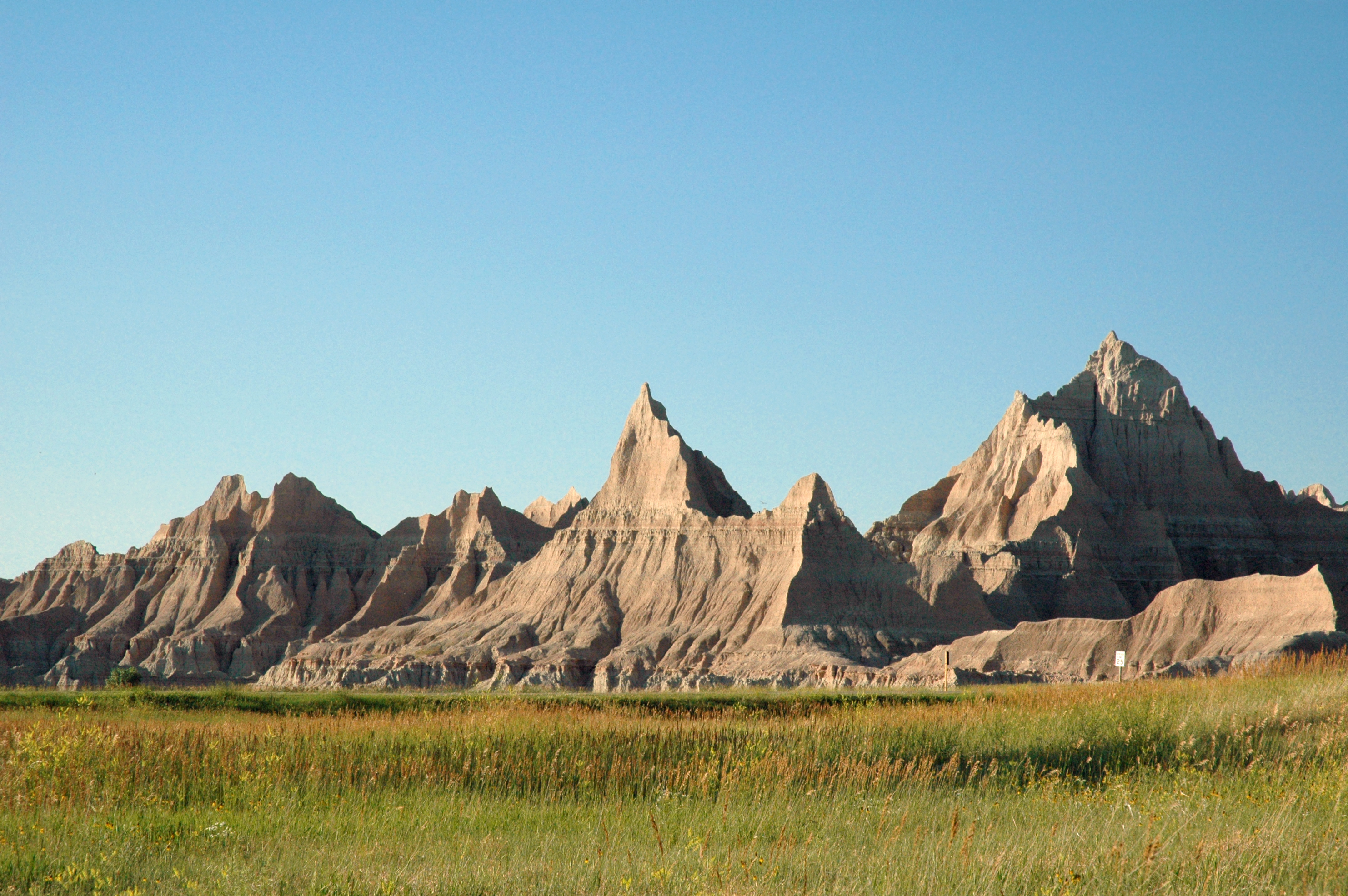
The White River Badlands of South Dakota consist of a scenic landscape of differentially weathered and eroded, nonmarine sedimentary rocks of Tertiary age.  The most visually-striking areas have been set aside as an American national park (Badlands).
The simplified stratigraphic succession in Badlands National Park is:
Sharps Formation (Oligocene)
Brule Formation (Oligocene)
Chadron Formation (Eocene)
Chamberlain Pass Formation (Eocene)
Fox Hills Formation (Cretaceous-Paleocene?)
Pierre Shale (Cretaceous)
The Brule and Chadron Formations make up the White River Group, which along with the overlying Sharps Formation, are the principal scenery-making units in the White River Badlands.  Light-colored volcanic ash beds are present in the succession, as are numerous reddish-colored paleosol ("fossil soil") horizons.  The Pierre Shale at the base of the exposed succession is a marine unit.
The White River Group weathers and erodes relatively quickly into a rugged landscape with steep slopes, little to no soil, and little to no vegetation.  These are the characteristics of badlands topography - "bad" referring to its unsuitability for farming.
Nonmarine fossils are relatively common in the White River Group - principally fossil mammals and other vertebrates.  Fossils in the Chadron Formation indicate a swampy, near-sea level environment.  The overling Brule Formation produces fossils consistent with a grassy prairie environment.  The transition from low-elevation swamp to higher-elevation prairie in this area coincides with the uplift of the Rocky Mountains during the late stages of the Laramide Orogeny.
Erosion rates in the White River Badlands indicate that the landscape started to appear about half-a-million years ago and will disappear about half-a-million years from now.  The landscape has about a one million year lifespan.
The hills seen here have two distinctive paleosol horizons.  The lower, thicker, yellowish-colored interval is the Yellow Mounds Paleosol, a Late Eocene ultisol.  The upper, thinner, reddish-colored interval is the Interior Paleosol, a Late Eocene alfisol.  The overlying rocks are the Upper Eocene Chadron Formation.
Stratigraphy: Yellow Mounds Paleosol (capping the Fox Hills Formation) and Interior Paleosol (capping the Chamberlain Pass Formation), basal White River Group, Chadronian Stage, Upper Eocene
Locality: Yellow Mounds Overlook area, White River Badlands, Badlands National Park, western South Dakota, USA


Online pub. covering the geology of Badlands National Park:

pubs.usgs.gov/of/2003/0035/pdf/of03-35.pdf
The White River Badlands of South Dakota consist of a scenic landscape of differentially weathered and eroded, nonmarine sedimentary rocks of Tertiary age. The most visually-striking areas have been set aside as an American national park (Badlands). The simplified stratigraphic succession in Badlands National Park is: Sharps Formation (Oligocene) Brule Formation (Oligocene) Chadron Formation (Eocene) Chamberlain Pass Formation (Eocene) Fox Hills Formation (Cretaceous-Paleocene?) Pierre Shale (Cretaceous) The Brule and Chadron Formations make up the White River Group, which along with the overlying Sharps Formation, are the principal scenery-making units in the White River Badlands. Light-colored volcanic ash beds are present in the succession, as are numerous reddish-colored paleosol ("fossil soil") horizons. The Pierre Shale at the base of the exposed succession is a marine unit. The White River Group weathers and erodes relatively quickly into a rugged landscape with steep slopes, little to no soil, and little to no vegetation. These are the characteristics of badlands topography - "bad" referring to its unsuitability for farming. Nonmarine fossils are relatively common in the White River Group - principally fossil mammals and other vertebrates. Fossils in the Chadron Formation indicate a swampy, near-sea level environment. The overling Brule Formation produces fossils consistent with a grassy prairie environment. The transition from low-elevation swamp to higher-elevation prairie in this area coincides with the uplift of the Rocky Mountains during the late stages of the Laramide Orogeny. Erosion rates in the White River Badlands indicate that the landscape started to appear about half-a-million years ago and will disappear about half-a-million years from now. The landscape has about a one million year lifespan. The hills seen here have two distinctive paleosol horizons. The lower, thicker, yellowish-colored interval is the Yellow Mounds Paleosol, a Late Eocene ultisol. The upper, thinner, reddish-colored interval is the Interior Paleosol, a Late Eocene alfisol. The overlying rocks are the Upper Eocene Chadron Formation. Stratigraphy: Yellow Mounds Paleosol (capping the Fox Hills Formation) and Interior Paleosol (capping the Chamberlain Pass Formation), basal White River Group, Chadronian Stage, Upper Eocene Locality: Yellow Mounds Overlook area, White River Badlands, Badlands National Park, western South Dakota, USA Online pub. covering the geology of Badlands National Park: pubs.usgs.gov/of/2003/0035/pdf/of03-35.pdf

The Badlands Wall

south-dakotanational-parkgeologyfossilsprairie
5 min read

Across southwestern South Dakota, a wall of eroded buttes and pinnacles divides the prairie like a geological fortification. The Badlands Wall is a 60-mile escarpment where the White River has carved deep into ancient sediments, exposing 75 million years of geological history in striped cliffs of pink, tan, and gray. The exposed formations contain one of the world's richest fossil beds - ancient sea creatures, three-toed horses, rhino-sized pigs, and saber-toothed cats have all been excavated from these eroding slopes. French-Canadian fur trappers called this terrain 'les mauvaises terres à traverser' - bad lands to cross. The Lakota called it 'mako sica.' Both were right. The Badlands are beautiful and brutal, eroding an inch per year, constantly revealing new fossils while destroying the landscape that contains them.

The Formation

The Badlands Wall exposes sediments deposited over 75 million years. The oldest visible layers are Pierre Shale - sediments from the Western Interior Seaway, the shallow sea that split North America during the Cretaceous. Above that, the Chadron and Brule Formations record the Eocene and Oligocene epochs - 34 to 25 million years ago - when rivers meandered across subtropical plains, depositing volcanic ash from eruptions to the west. These sediments hardened into layers of varying resistance: some erode quickly, some slowly, creating the distinctive banded appearance. Where the White River and its tributaries cut into the plain, the Badlands Wall emerged - a dramatic boundary between prairie above and eroded terrain below.

The Fossils

The Badlands contain some of the world's richest Oligocene fossil beds. Ancient mammals preserved here include oreodonts (pig-like herbivores that roamed in vast herds), three-toed horses, rhino-like titanotheres, saber-toothed nimravids, and early camels. Marine fossils from the older Pierre Shale include mosasaurs, ammonites, and giant sea turtles. Paleontologists have worked these formations since the 1840s; fossils continue emerging as erosion exposes new specimens. The park's fossil preparation lab allows visitors to watch scientists working on recent finds. Private collecting is prohibited; the fossils belong to the public and to science.

The Erosion

The Badlands are temporary. The cliffs erode approximately one inch per year - fast in geological terms. Each rainstorm washes away sediment; each freeze-thaw cycle cracks the rock. The formations visible today will be gone in thousands of years, not millions. This rapid erosion reveals fossils that would otherwise remain buried, but also destroys the landscape. The Badlands Wall retreats west; the escarpment migrates across the prairie. Visitors a thousand years from now will see a different landscape - the same process, different pinnacles, new fossils exposed and then destroyed by the same forces that created this view.

The Park

Badlands National Park protects 244,000 acres of eroded prairie and mixed-grass ecosystem. The park was established as a national monument in 1939 and redesignated a national park in 1978. The Badlands Loop Road (Route 240) offers overlooks along the Wall, with stops at scenic viewpoints and trailheads. Hiking ranges from easy boardwalks to challenging scrambles into the formations. The Stronghold Unit, co-managed with the Oglala Sioux, includes areas used by the Lakota and sites related to the Ghost Dance movement of 1890. Prairie wildlife includes bison (reintroduced), bighorn sheep, pronghorn, prairie dogs, and black-footed ferrets (one of the world's most endangered mammals).

Visiting Badlands National Park

Badlands National Park is located in southwestern South Dakota, accessible via Interstate 90 (exits at Cactus Flat or Wall). The Ben Reifel Visitor Center at Cedar Pass has exhibits and an orientation film. The Badlands Loop Road (Route 240) connects the park's main overlooks and can be driven in 1-2 hours without stops. The town of Wall (home of Wall Drug) is at the park's northern edge. Rapid City is 75 miles west; Mount Rushmore is 90 miles west. Rapid City Regional Airport provides commercial service. The park charges entrance fees (National Parks pass accepted). Summer brings crowds and heat; spring and fall offer comfortable weather and fewer visitors. Sunrise and sunset light the formations spectacularly.

From the Air

Located at 43.75°N, 102.50°W in southwestern South Dakota. From altitude, the Badlands Wall is dramatically visible - a jagged escarpment dividing smooth prairie to the north from eroded terrain to the south. The striped formations are distinctive even from high altitude, the erosion patterns creating a rugged topography that contrasts sharply with surrounding grasslands. The Badlands Loop Road is visible threading through the formations. Rapid City is 75 miles west; the Black Hills are visible on the western horizon. The Wall, South Dakota, is at the park's northern edge. Interstate 90 parallels the park's northern boundary.