Bajo Nuevo Bank
From the air, it looks like a mistake -- a faint turquoise smudge in the deep blue of the western Caribbean that could be a trick of the light or a glitch on the navigation chart. Bajo Nuevo Bank is easy to miss, and for good reason. Its largest piece of dry land, Low Cay, measures 300 meters long and 40 meters wide, rises no more than two meters above the waterline, and consists mostly of broken coral, sand, and driftwood. There are no trees. There are no people. There is, however, a 21-meter lighthouse tower painted white with a red top, flashing twice every 15 seconds, and behind that lighthouse stands one of the most tangled sovereignty disputes in the Western Hemisphere -- a legal knot involving Colombia, Jamaica, the United States, and a 19th-century law about bird droppings.
Cartographers, Pirates, and a Name
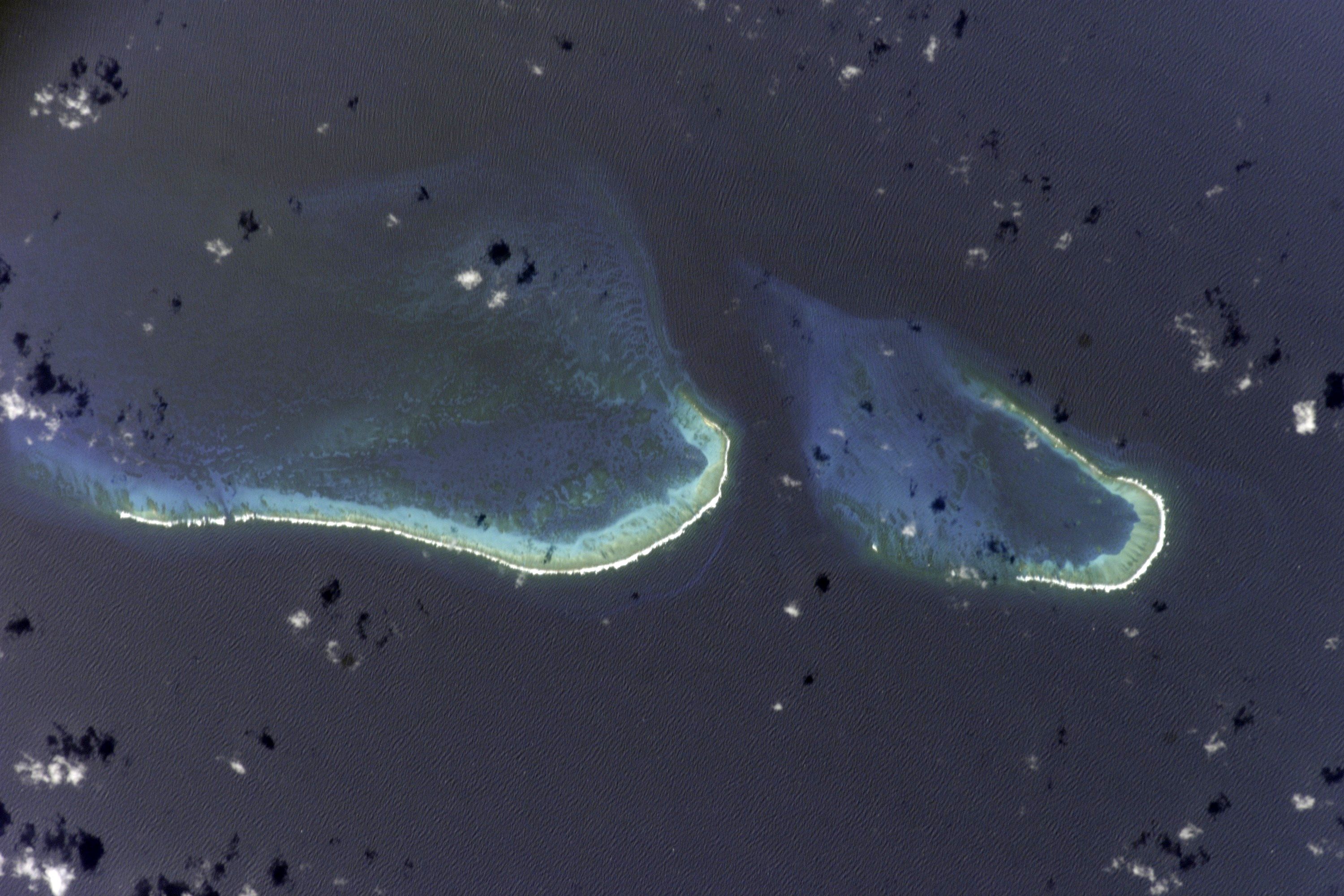
Dutch mapmakers first charted the reef in 1634, though it took another two decades for it to acquire its current name, which appeared on charts by 1654. In 1660, the English pirate John Glover "rediscovered" the bank -- a reminder that in the age of Caribbean piracy, discovery and rediscovery were often the same thing viewed from different flags. The reef then largely vanished from the historical record for two centuries, existing primarily as a hazard notation on sailing charts. What the pirates and cartographers were circling was a structure of considerable size hiding just below the surface: two distinct atoll-like reef complexes separated by a deep channel 1.4 kilometers wide at its narrowest point. The southwestern complex stretches 15.4 kilometers and covers roughly 100 square kilometers of shallow water; the northeastern complex adds another 45 square kilometers. Beneath the Caribbean's surface, Bajo Nuevo is enormous. Above it, almost nothing.
The Lighthouse on Nothing
Low Cay, the only feature that consistently breaks the surface, sits in the southwestern atoll. It is barren in the most literal sense -- no soil, no vegetation, no freshwater. The Colombian government erected a light beacon here in 1982, and the Ministry of National Defence reconstructed it in February 2008. The Colombian National Navy maintains the beacon and patrols the surrounding waters from the San Andrés fleet. That a nation would build and maintain a lighthouse on a strip of coral barely larger than a football pitch tells you everything about what Bajo Nuevo really is: not a place anyone wants to live, but a place several nations insist on owning. The beacon's two white flashes every 15 seconds serve as both a navigation aid and a quiet assertion -- this belongs to someone, even if no one stays.
Four Flags Over Bird Droppings
The sovereignty dispute over Bajo Nuevo reads like a legal thriller written by a committee. Colombia claims the bank as part of the Department of San Andrés and Providencia, arguing continuous sovereignty since 1886. The United States staked its claim on November 22, 1869, when James W. Jennett invoked the Guano Islands Act -- an 1856 law that allowed U.S. citizens to claim uninhabited islands containing guano deposits for the nation. Most American guano claims in the region were renounced in a 1972 treaty with Colombia, but Bajo Nuevo was conspicuously absent from that document, and Article 7 of the treaty states that matters not specifically mentioned are not subject to its terms. The U.S. still considers the bank an insular area. Jamaica's involvement grew from bilateral fishing agreements with Colombia between 1982 and 1986 that granted Jamaican vessels regulated access to the territorial waters. Critics argued Jamaica's signing amounted to de facto recognition of Colombian sovereignty, though the matter has never been formally resolved.
The Court Weighs In
Honduras added a fourth layer to the dispute before ratifying a maritime boundary treaty with Colombia on December 20, 1999, which effectively removed its claim. A 1986 bilateral agreement had already excluded Honduras from control over the banks or their surrounding waters. But the most consequential legal moment came on November 19, 2012, when the International Court of Justice ruled on Nicaraguan claims to the islands. The ICJ found unanimously that Colombia holds sovereignty over both Bajo Nuevo and nearby Serranilla Bank, located 110 kilometers to the west. The ruling was significant but incomplete -- the court did not address the competing claims of Jamaica or the United States. So the legal tangle persists: one court ruling in Colombia's favor, one lingering American claim rooted in a law about guano, one ambiguous Jamaican position, and a reef that continues to sit in the Caribbean, indifferent to all of it.
The Reef Below the Arguments
Strip away the sovereignty claims and treaty language, and what remains is a remarkable piece of marine geography. Bajo Nuevo Bank is a living reef system in the open Caribbean, far from any continental shelf, sustaining itself in deep oceanic waters roughly 110 kilometers from its nearest neighbor, Serranilla Bank. The two atoll-like structures create shallow lagoons where marine life concentrates -- a biological oasis in an otherwise featureless stretch of sea. The reef partially dries on its southern and eastern edges, meaning that at low tide, coral formations break the surface in patterns visible from altitude. For the seabirds that give the bank its alternate name -- the Petrel Islands -- this is nesting ground and hunting territory, a place defined not by human boundaries but by wind, current, and the slow accretion of coral over millennia.
From the Air
Located at 15.88°N, 78.63°W in the open western Caribbean Sea, roughly 110 km east of Serranilla Bank. From altitude, look for two distinct turquoise atoll shapes against the deep blue ocean -- the larger southwestern complex (15.4 km long) and smaller northeastern complex (10.5 km long) separated by a dark channel. The 21-meter white-and-red lighthouse tower on Low Cay is the only man-made structure. No nearby airports; the closest airfields are on San Andrés Island (SKSP), approximately 380 km to the southwest, or in Jamaica. Best viewed from medium altitude (5,000-15,000 feet) where the reef structure and color contrast with deep water are most dramatic.