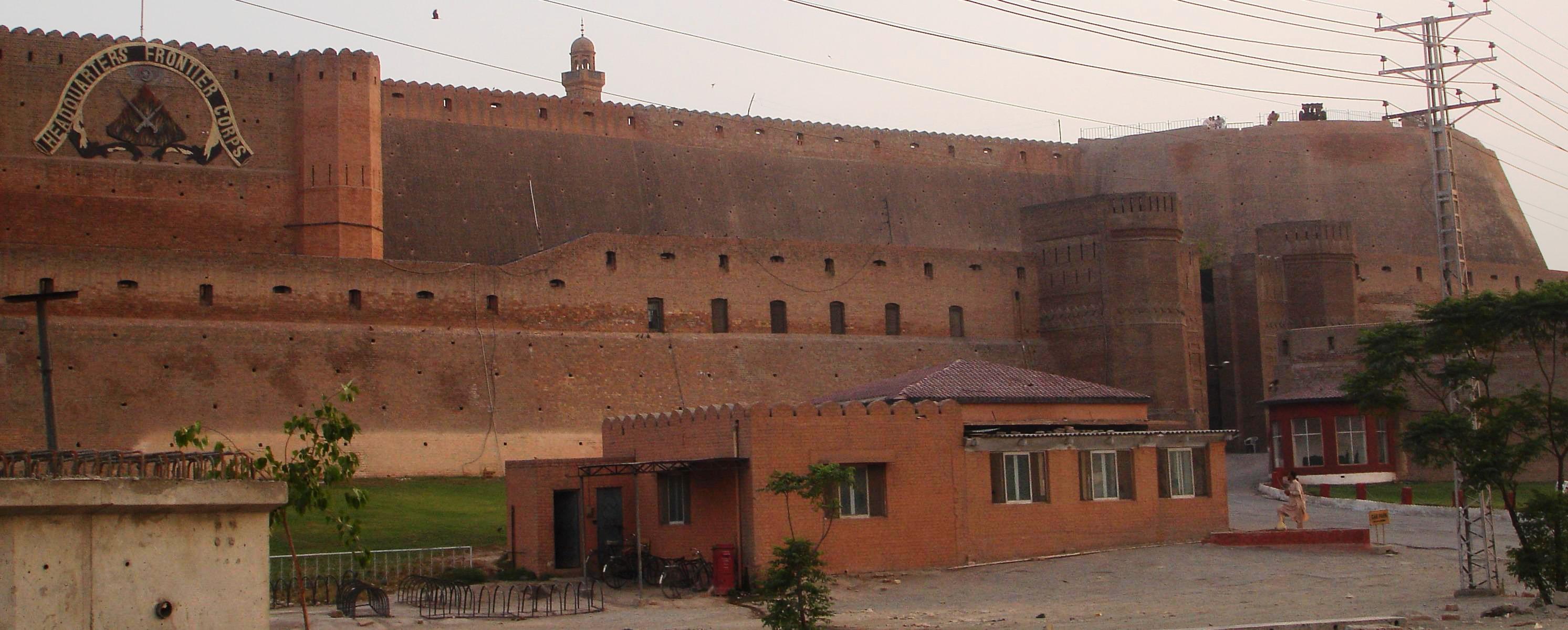
Bala Hissar, Peshawar
In 630 AD, a Chinese Buddhist monk named Xuanzang walked into Peshawar and found a royal residence on a fortified mound. He called it Kung Shing -- the walled place where the palace stood. Nearly fourteen centuries later, Pakistan's Frontier Corps runs its operations from the same high ground. Between those two moments, Bala Hissar has been seized, burned, rebuilt, and renamed by nearly every power that has tried to hold the Peshawar Valley: the Mughals, the Afghan Durranis, the Marathas, the Sikhs, and the British East India Company. The name itself, from Dari Persian, means simply "elevated fort." The simplicity is apt. What matters about Bala Hissar has never been its name but its position.
The Mound That Commands a Valley
The fort sits on a high mound in the northwestern corner of Peshawar. Until recently, open ground separated it from the old city, but new construction has closed that gap, and buildings now crowd up against the fort's base. The elevation still matters. From the ramparts, you can see the entire Peshawar Valley spreading out to the south and east -- the same panoramic sightline that made this spot valuable to every ruler who held it. Historian Ahmad Hasan Dani traced the citadel's origins to a channel of the old Bara River that surrounded the high ground, creating a natural defensive position enhanced by a moat. The higher area, encompassing both the Bala Hissar and the adjacent Inder Shahr, would have formed the fortified nucleus of the ancient city while the unfortified settlement spread out below.
A Fort by Many Names
Names have accumulated on this place like layers of sediment. During the Mughal and Sur empires, it was called Bagram Fort, after Bagram -- an older name for Peshawar itself. When Ahmad Shah Durrani conquered the city in 1747 and made Peshawar the winter capital of his Afghan empire, the fort became a royal residence. His grandson Timur Shah Durrani gave it the Persian name Bala Hissar, though according to historian Hussain Khan, the formal designation never fully stuck -- people kept defaulting to the simpler Bala Hissar. Even Emperor Babur, visiting centuries earlier, still called it Bagram Fort. The Mughal name referred backward to the city's Buddhist-era identity; the Durrani name gestured upward toward the sky. Both were trying to claim the same piece of ground.
Conquered, Destroyed, Rebuilt
The Marathas briefly seized the fort in 1758 after capturing Peshawar -- extending their rule an astonishing 2,000 kilometers from their capital in Pune to the borders of Afghanistan -- but the Afghans soon retook it. The more lasting transformation came in March 1823, when the Sikhs defeated the Afghans at the Battle of Nowshera and marched into Peshawar. They did not simply occupy Bala Hissar; they destroyed the Afghan royal court and the fort itself, then rebuilt it under the command of Hari Singh Nalwa, the Sikh commander-in-chief. After the First Anglo-Sikh War of 1845-46, the British East India Company took control and reconstructed the outer walls in 1849, giving the fort roughly the form it holds today. Each conqueror left their mark in the masonry, layering Sikh brick over Afghan stone over Mughal foundation.
Soldiers and Tourists
Today Bala Hissar serves as headquarters for the Frontier Corps, a paramilitary unit of the Pakistan Army responsible for security in the tribal border regions. A military installation occupying an ancient fortress sounds like the natural order of things in Peshawar, where the strategic and the historical have never been separable. The provincial government of Khyber Pakhtunkhwa has pushed to open the fort to tourists, and limited visiting hours have been established -- Saturdays for families, Sundays for general visitors, no admission fee. A small Frontier Corps museum inside displays uniforms and weapons spanning the unit's history. International visitors need their passports; Pakistani citizens bring their national identity cards. The fort that Xuanzang visited as a curious pilgrim in 630 AD is, in its way, still receiving visitors -- though now they pass through security checkpoints rather than monastery gates.
From the Air
Located at 34.013N, 71.570E on a prominent mound in the northwestern corner of Peshawar's old city. The fort is clearly visible from the air as an elevated, walled compound distinct from the surrounding urban sprawl. Bacha Khan International Airport (OPPS) lies approximately 4 km to the northwest. Best viewed from 2,000-4,000 feet AGL. The Peshawar Valley spreads to the south and east, with the Khyber Pass visible to the northwest in clear conditions. All Saints Church sits roughly 1 km to the southeast.