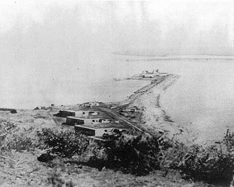
Ballast Point Lighthouse
The name tells you everything about this place. Early Yankee ship captains gathered stones from this tiny peninsula jutting into San Diego Bay, loading them as ballast for the long voyage around Cape Horn back to Boston. That practical tradition gave Ballast Point its name, and in 1890, a lighthouse rose here to guide vessels into the harbor. It would be the last fixed-light lighthouse on the Pacific coast. When the tower came down in 1960, its lantern room began a strange journey across San Diego County that continues today.
Where Explorers Anchored
Juan Rodriguez Cabrillo dropped anchor in the quiet waters inside Ballast Point on September 28, 1542, after five months of battling headwinds from the Port of Navidad. He named the harbor San Miguel and stayed six days. Sixty years passed before another European keel disturbed these waters: Sebastian Vizcaino arrived on November 10, 1602, renaming the place San Diego in honor of that saint's day. When Spain decided to occupy the territory in 1769, supply ships arrived on haphazard schedules. The clipper Aranzaya reached Ballast Point in 1795 carrying three workmen and timber to build a fort at what was then called Point Guijarros.
The Whale Killers
Shore whaling made perfect sense at Ballast Point: the whales came to the whalers rather than the other way around. Gray whales migrating along the California coast passed close to Point Loma, and hunting boats could intercept them without long voyages. Workers towed the massive carcasses to the point, where blubber was rendered in 150-gallon try pots. The stench must have been tremendous, the work backbreaking, but the oil that emerged lit lamps and lubricated machinery across a growing nation.
The Fifth-Order Light
In 1890, the Lighthouse Service constructed Ballast Point Light. The original buildings included two dwellings and a white square tower that formed part of the keeper's quarters. Inside the brass and glass lantern sat a fifth-order fixed classical lens with a green shade. This was no rotating beacon but a steady glow that mariners could distinguish from other lights along the coast. It remained the last fixed light on the Pacific, an anachronism that persisted while other stations converted to flashing signals.
Demolition and Diaspora
In June 1960, workers tore down the old dwellings, leaving the tower standing alone. Repairs revealed the problem: the brick and mortar foundation had failed, making the structure unstable. The tower came down, but the lighthouse did not vanish entirely. The lantern room bounced around San Diego County before settling outside the West Sea Company in Old Town, at 2495 Congress Street, where visitors can still see it. The fog signal tower was moved in 1961 to a private home in Lakeside, California, where it remains.
The Light Remains
Ballast Point itself became part of Naval Base Point Loma, closed to casual visitors. But the light continues. An automated beacon stands on a piling in the water off the original site, listed as USCG number 6-1570, showing a white flash every four seconds. A daymark and fog horn complete the modern installation. The function persists even if the form has changed. Ships still need guidance into San Diego Bay, and where early sailors gathered stones for ballast, a light still shines.
From the Air
Located at 32.69N, 117.23W on the Point Loma peninsula at the entrance to San Diego Bay. The site is within Naval Base Point Loma and not publicly accessible. Best viewed from San Diego Bay or from altitude. Nearby airports include San Diego International (KSAN) and North Island Naval Air Station (KNZY). Point Loma's distinctive shape and the Cabrillo National Monument provide visual references.