Baltoro Glacier
Nowhere else on Earth do so many of the highest mountains crowd so closely together. Within a 20-kilometer radius of the Baltoro Glacier's upper reaches, four peaks exceed 8,000 meters: K2 at 8,611 meters, Gasherbrum I at 8,080, Broad Peak at 8,047, and Gasherbrum II at 8,035. The glacier itself stretches through the heart of the Karakoram range in Pakistan's Gilgit-Baltistan region, collecting ice from a constellation of tributary glaciers that drain these giants. Where the Baltoro meets the Godwin-Austen Glacier descending from K2, a junction called Concordia opens into a natural amphitheater of rock and ice that mountaineers have compared to a cathedral nave -- except that the ceiling is the summit of the second-highest mountain on the planet.
The Architecture of Ice
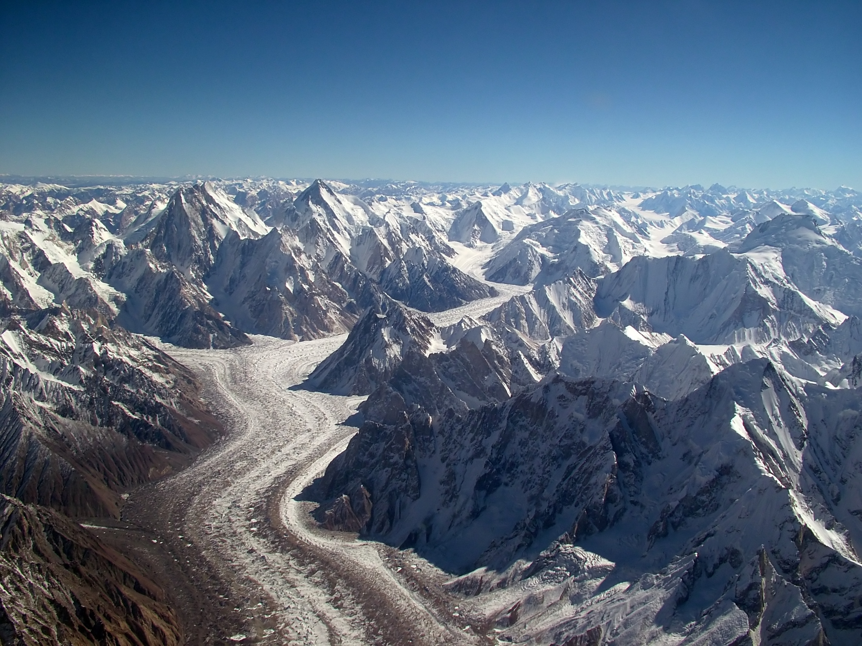
The Baltoro flows through an unusually wide trough bordered by the Baltoro Muztagh to the north and east and the Masherbrum Mountains to the south. Its surface is a chaos of moraines, crevasses, and glacial debris -- not the clean white expanse that the word "glacier" might suggest, but a fractured, rubble-strewn conveyor belt of ice grinding slowly westward. Small valley glaciers pour into the main trunk from both sides, forming icefalls where they meet. The steep sidewalls bear striations carved by millennia of grinding ice, and depressions gouged by glacial movement hold lakes that appear and vanish with the seasons. At its northeastern edge, the Conway Saddle separates the Baltoro from the Siachen Glacier, the world's highest battlefield. The Baltoro's meltwater feeds the Braldo River, which joins the Shigar River and eventually the Indus -- one of the great river systems of South Asia, sustained in part by this frozen reservoir high in the Karakoram.
A Corridor of Giants
The list of peaks flanking the Baltoro reads like a roll call of mountaineering's most formidable challenges. K2, the savage mountain, rises at the glacier's head -- a peak with a fatality rate that far exceeds Everest's. Broad Peak and the four Gasherbrum summits line the eastern wall. To the south, Masherbrum stands at 7,821 meters, and Chogolisa -- where the great Hermann Buhl vanished in 1957 -- reaches 7,665 meters. The Trango Towers, though modest by Karakoram standards at 6,286 meters, possess vertical rock faces that rank among the tallest cliffs on Earth. Muztagh Tower, at 7,273 meters, defeated multiple expeditions before its first ascent in 1956. Even the lesser peaks would dominate any other mountain range. Mitre Peak at 6,010 meters would be the highest summit in the Alps by nearly a kilometer. Here, it barely registers against its neighbors.
Concordia and the Trek
Every expedition to K2 and most climbs of the Gasherbrum peaks begin with a trek up the Baltoro from Skardu, the Balti town that serves as the principal gateway to the Karakoram. The journey takes roughly a week on foot, passing through campsites with names that have entered mountaineering lore: Paiju, Urdukas, Gore, Concordia. At Concordia, where the Baltoro and Godwin-Austen glaciers converge at 4,691 meters, the view opens to reveal K2's full south face rising more than 4,000 meters above. Scientific observations between 2001 and 2011 recorded visible changes near Concordia, documenting the glacier's response to shifting climate patterns. The trek itself has become one of the world's great mountain journeys -- not a technical climb but a sustained walk through a landscape of such vertical scale that the human eye struggles to process the distances involved.
Garbage on the Glacier
Improved road access to Skardu has transformed the Baltoro from a destination for elite mountaineers into an increasingly popular trekking route, and the consequences are visible at every campsite. Litter, inadequate sanitation, and the heavy use of overburdened mules have left trails strewn with waste and animal remains. In the 1990s and 2000s, the Mountain and Glacier Protection Organisation introduced campsites with portable toilets and waste collection systems. Those early efforts made a difference, but conditions have since deteriorated under the management of the Central Karakoram National Park. Accumulated trash piles up at campsites. Community incentives for cleanup are limited, and waste disposal systems have proven inadequate for the volume of visitors. Current initiatives, including the United Nations Development Programme's GLOF II project supported by the Green Climate Fund, aim to restore the glacier's cleanliness. Local residents have advocated for systematic annual cleanups managed by a single responsible authority rather than the fragmented oversight that has allowed the problem to worsen.
Seen from Above
From the International Space Station, the Baltoro appears as a pale gray tongue winding through dark rock, its tributaries splaying like the veins of a leaf. The scale becomes comprehensible only from this altitude -- the glacier's length, the enormity of the peaks that flank it, the sheer density of ice and rock packed into this corner of the Karakoram. On the ground, trekkers spend a week walking its length. From 400 kilometers up, the entire glacier fits within a single photograph. Between these two perspectives lies the Baltoro's essential quality: it is a landscape that defies human scale. The mountains are too tall, the glacier too vast, the distances too great for the mind to hold at once. You experience it in fragments -- a summit catching morning light, an icefall groaning in the afternoon heat, the shadow of K2 stretching across Concordia at sunset -- and assemble something like understanding only after you have left.
From the Air
Located at 35.74N, 76.38E in the Karakoram range, Gilgit-Baltistan, Pakistan. The glacier flows roughly east-to-west, with K2 (8,611m) visible at its head. Concordia, where the Baltoro and Godwin-Austen glaciers meet, sits at approximately 4,600 meters. The terrain is extremely high -- surrounding peaks exceed 7,000 to 8,000 meters, so viewing altitude must account for the mountains themselves. Nearest major airfield: Skardu Airport (OPSD), approximately 90 km to the southwest. Islamabad (OPRN) is the nearest international gateway. Best viewed from 30,000+ feet to clear the surrounding peaks. In clear weather the glacier and its tributary system are visible as a distinctive branching pattern of ice against dark rock.