Baluarte Bridge
Four hundred meters below the road deck, the Baluarte River carves through a gorge so deep that France's Millau Viaduct -- the previous record holder -- would sit 120 meters lower if transplanted here. The Baluarte Bicentennial Bridge does not merely cross a canyon in the Sierra Madre Occidental. It eliminates one of the most punishing geographic barriers in North America, connecting the Pacific port of Mazatlan with the highland city of Durango on a highway that turns an eight-hour ordeal into a two-and-a-half-hour drive.
Bridging Two Mexicos
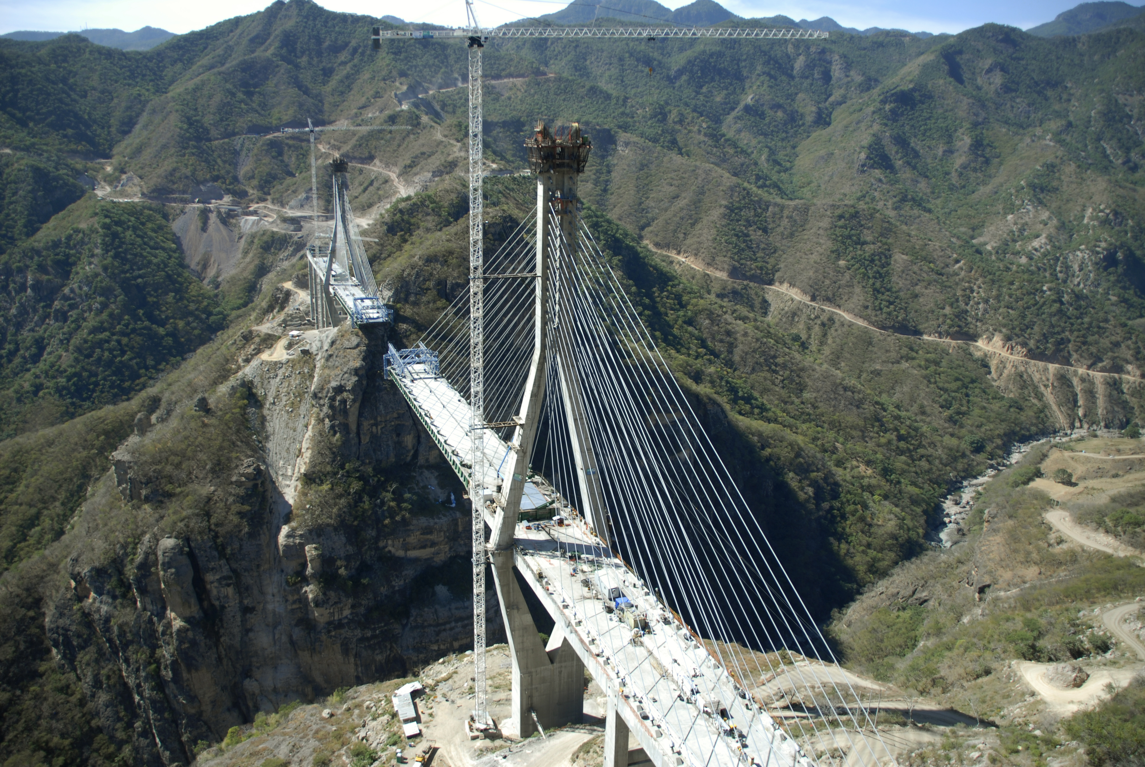
For centuries, the Sierra Madre Occidental divided western Mexico into two worlds: the hot Pacific lowlands of Sinaloa and the cool altiplano of Durango. Mule trains, then narrow mountain roads with dozens of hairpin turns, were the only connections. The old Highway 40 was notorious -- a serpentine, landslide-prone route that truckers dreaded and tourists avoided. The new Durango-Mazatlan highway, with the Baluarte Bridge as its showpiece, changed the equation entirely. The highway runs 230 kilometers through 63 tunnels and across 115 bridges, but it is the Baluarte that captures the imagination. Its total length is 1,124 meters, with a central cable-stayed span of 520 meters -- the longest such span in North America, 37 meters longer than Louisiana's John James Audubon Bridge.
Engineering Above the Clouds
Construction began on February 21, 2008, carried out by a consortium that included Tradeco Infraestructura, IDINSA, Aceros Corey, and VSL Mexico. The cable-stayed design was chosen for a practical reason: it allowed builders to work outward from each of the two main pylons, eliminating the need for falsework -- temporary support structures -- in a gorge where building from below was essentially impossible. Workers excavated 447,000 cubic meters of rock to lay the foundations. The bridge cost 2.18 billion pesos, roughly 158.7 million US dollars. Originally planned for inauguration during Mexico's 2010 bicentennial celebrations -- hence the name -- construction delays pushed the opening to January 2012, when it received a Guinness World Record for the highest cable-stayed bridge.
A Name and Its Meaning
The 'Bicentennial' in the bridge's official name refers to the 200th anniversary of Mexico's declaration of independence from Spain, which launched the Mexican War of Independence in 1810. Naming the bridge after this founding moment was intentional: the Durango-Mazatlan highway represents a kind of national reunification, stitching together regions that geography had kept apart since long before independence. The Baluarte River itself takes its name from the Spanish word for 'bastion' or 'bulwark,' an apt description for a gorge that defended its own impassability for millennia. That the river's name evokes fortress walls makes the bridge's achievement more pointed -- it is infrastructure as conquest of terrain, built not with armies but with cables and concrete.
The View from Above
From the air, the bridge is unmistakable: a slender white line suspended between green mountain ridges, the cables fanning out from its pylons like the ribs of a wing. The gorge beneath drops away in layers of exposed rock, the river a thin silver thread at the bottom. For drivers crossing on the road deck, the experience is more subtle -- guardrails and pavement create a sense of ordinary highway, until a glance sideways reveals nothing but sky and the distant canyon floor. The bridge transformed not just travel times but economic geography. Produce from the Durango highlands and seafood from Mazatlan's port now move between coast and interior in hours rather than a full day, and the highway has opened the Sierra Madre's rugged interior to tourism that was previously impractical.
From the Air
The Baluarte Bridge is located at 23.53N, 105.76W in the Sierra Madre Occidental between Sinaloa and Durango. The bridge is a striking visual landmark from the air -- look for the cable-stayed span crossing a deep gorge along the Durango-Mazatlan highway (Mexico 40D). Best viewed at 5,000-8,000 ft AGL. The nearest airport is General Rafael Buelna International (ICAO: MMMZ) in Mazatlan, approximately 100 km to the west. General Guadalupe Victoria International Airport (ICAO: MMDO) in Durango is roughly 130 km to the east. Clear conditions recommended as mountain fog is common.