Bam, Iran
In the tenth century, the Arab geographer Ibn Hawqal wrote that the cotton cloths woven in Bam were "excellent, beautiful, and long-lasting," shipped to Khorasan, Iraq, and Egypt, each garment worth thirty dinars. A thousand years later, on the morning of December 26, 2003, those same streets lay in silence. A magnitude 6.6 earthquake had struck at 5:26 AM while the city slept, collapsing mud-brick homes onto their occupants and reducing the ancient citadel of Arg-e Bam -- likely the largest adobe structure on Earth -- to rubble. More than 26,000 people died in a matter of seconds. The story of Bam is the story of what endures and what does not -- a city abandoned, rebuilt, destroyed, and rebuilt again across two millennia in the deserts of Kerman province.
Threads Along the Silk Road
Bam's origins reach back at least to the Achaemenid Empire in the sixth century BC, though the citadel took shape during the Parthian era. By the seventh century, the city sat at a crossroads of the Silk Road, producing silk and cotton textiles that traveled thousands of miles to distant markets. The citadel complex -- Arg-e Bam -- grew into a fortified city within a city, its towering mud walls enclosing a bazaar, a mosque, residential quarters, and a governor's compound. Beneath the surface, an even more remarkable feat of engineering sustained everything: a vast network of qanats, underground channels that tapped groundwater and delivered it to date palm groves and cotton fields. A geological fault line running through the region acts like a natural dam, concentrating water on the western side -- Bam's qanats produced several times more water than similar systems elsewhere. This abundance transformed a patch of the Dasht-e Lut desert into a green oasis.
Conquest and Abandonment
For all its prosperity, Bam's history is punctuated by collapse. During the Safavid dynasty, most of the citadel's standing structures were built or rebuilt and the city flourished. Then in 1722, an Afghan invasion led by Mahmud Hotak swept through the region, and Bam was largely abandoned. Settlers gradually returned, only to be driven out again by raiders from Shiraz. The citadel served time as an army barracks before the modern city began to grow around it, fed by agriculture rather than trade. Date palms replaced cotton as the economic backbone -- particularly the Mozafati date, a soft, dark variety harvested in the mountainous Darbam district, prized across Iran and exported internationally. Citrus groves added to the productivity, all watered by the same qanat network that had sustained Silk Road caravans centuries earlier. By 2003, the modern city had grown to roughly 43,000 people, and tourism to the ancient citadel was rising.
Five Twenty-Six in the Morning
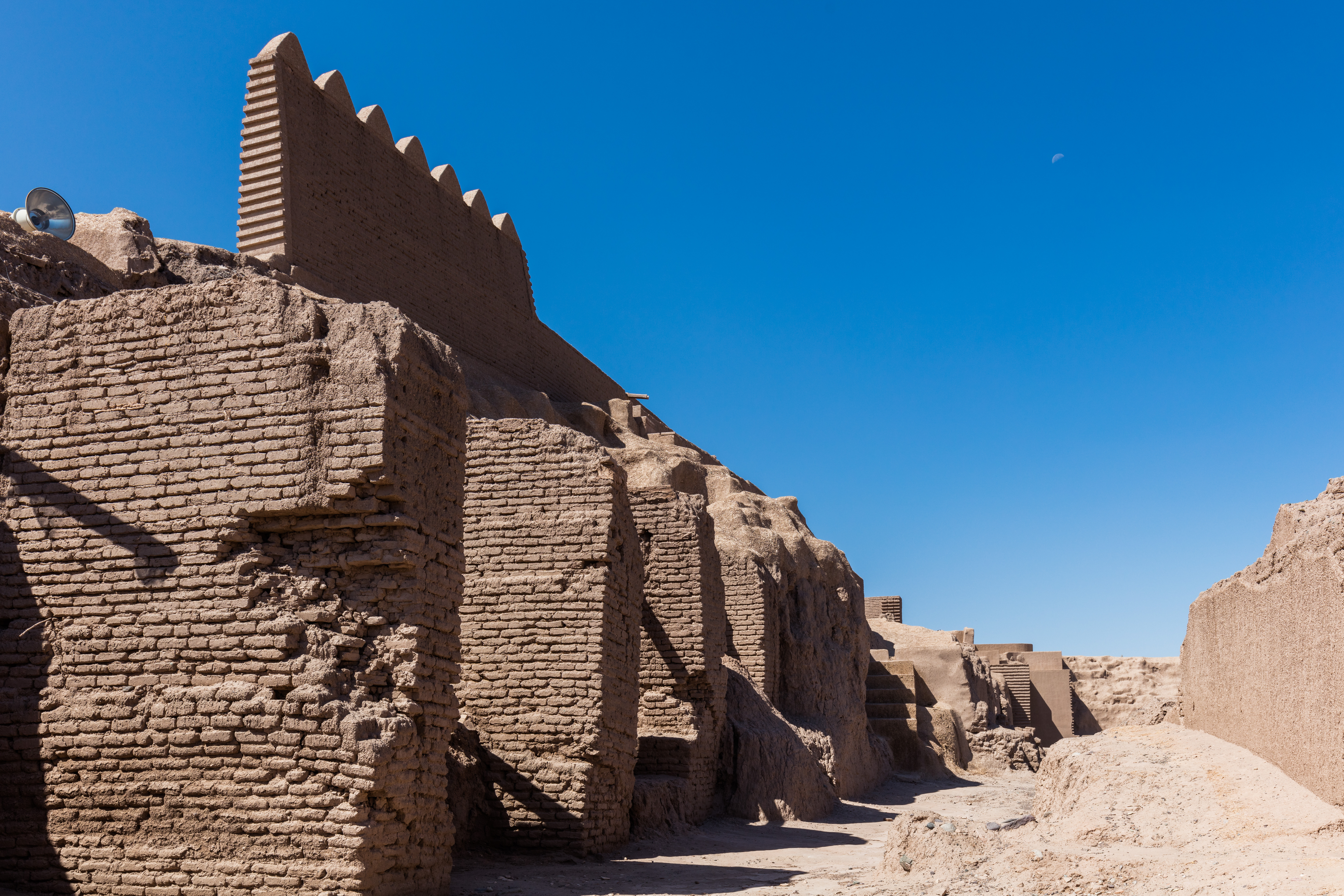
The earthquake arrived in darkness. At 5:26 AM local time on December 26, 2003, a shallow rupture along a previously unmapped fault released a magnitude 6.6 tremor directly beneath the city. The destruction was catastrophic. Bam's buildings were overwhelmingly constructed of mud brick, many of them noncompliant with the seismic codes Iran had adopted in 1989. Because nearly everyone was indoors and asleep, the death toll reached 26,271, with another 30,000 injured and roughly 100,000 left homeless. The citadel, which had survived invasions, centuries of neglect, and the slow erosion of desert wind, lost more than eighty percent of its structure in seconds. Satellite images showed a city reduced to a uniform tan -- the color of pulverized adobe indistinguishable from the desert floor. Forty-four countries sent rescue teams. Sixty nations offered aid. In a rare moment of geopolitical thaw, the United States extended direct humanitarian assistance to Iran, and Iran in turn pledged cooperation with the International Atomic Energy Agency on nuclear monitoring.
Rising from Dust
Reconstruction began almost immediately, though the path forward was contentious. The Iranian government proposed a new city plan based on population management principles, which drew complaints from survivors who wanted to rebuild where they had lived. The plan went forward regardless, and a modern Bam gradually took shape. By 2016, the population had rebounded to 127,396 -- triple the pre-earthquake figure. The citadel's restoration proceeded more carefully. UNESCO inscribed Bam and its Cultural Landscape as a World Heritage Site in 2004 and simultaneously placed it on the List of World Heritage in Danger. Japan, Italy, and France joined Iran in the painstaking work of rebuilding Arg-e Bam using traditional earthen techniques -- mud layers called chineh and sun-dried bricks called khesht. By 2013, enough progress had been made to remove the site from the endangered list. The reconstruction continues today, a slow act of architectural memory performed in the same materials that people have been shaping here for two thousand years.
The Oasis Persists
Fly over Bam on a clear day and the contrast is stark: endless brown desert scored by the faint lines of ancient qanat shafts, then a sudden rectangle of green where date palms crowd together in dense groves. The citadel sits at the northern edge of the modern city, its restored walls casting sharp shadows in the desert light. Kerman lies 190 kilometers to the northwest; the Dasht-e Lut stretches to the east. Bam receives only about 60 millimeters of rain per year, yet it remains an oasis -- the qanats still flow, the dates still ripen, and the rebuilt walls still rise. The earthquake took almost everything in an instant, but it could not take the water underground or the knowledge of how to build with earth.
From the Air
Bam sits at 29.11N, 58.36E in southeastern Iran's Kerman province, elevation approximately 1,060 meters (3,478 feet). The ancient citadel of Arg-e Bam is visible from altitude on the city's northern edge as a distinct walled compound. Bam Airport (OIKM) lies just south of the city. Kerman Airport (OIKK) is 190 km to the northwest. The surrounding terrain is flat desert with the Dasht-e Lut to the east. Date palm groves create a visible green patch against the brown desert floor. Best viewed in clear conditions; the region has a hot desert climate with very low rainfall.