Bandelier National Monument: Where Cliff Dwellers Met the Atomic Age
"It is the grandest thing I ever saw." When Swiss-American anthropologist Adolph Bandelier peered into Frijoles Canyon in 1880, guided there by a Pueblo man named Jose Montoya, he was looking at something remarkable: hundreds of rooms carved directly into the soft volcanic rock of the canyon walls, abandoned centuries before but still standing. The cliff dwellings and pueblo ruins of what would become Bandelier National Monument preserve one of the most complete records of Ancestral Puebloan life in the Southwest, set against a landscape sculpted by one of North America's most violent volcanic eruptions. The canyon would later serve a very different kind of history, housing scientists building the atomic bomb.
Born from Volcanic Fire
The landscape of Bandelier was created 1.14 million years ago when the Valles Caldera volcano erupted with catastrophic force, blanketing the surrounding region in volcanic ash that solidified into a rock formation called the Bandelier Tuff. This tuff, deposited over Permian-age shales and sandstones and Pennsylvanian-age limestone, varied dramatically in hardness. That variation would prove critical to the people who arrived thousands of years later. The softer tuff could be hollowed out by hand to create sheltered rooms called cavates. The harder material could be broken into bricks for construction. The Pajarito Plateau, where the monument sits on the slopes of the Jemez Mountains, spans over a mile of elevation change from the Rio Grande to the rim of the Valles Caldera, creating a remarkable diversity of habitats and life zones within a single landscape.
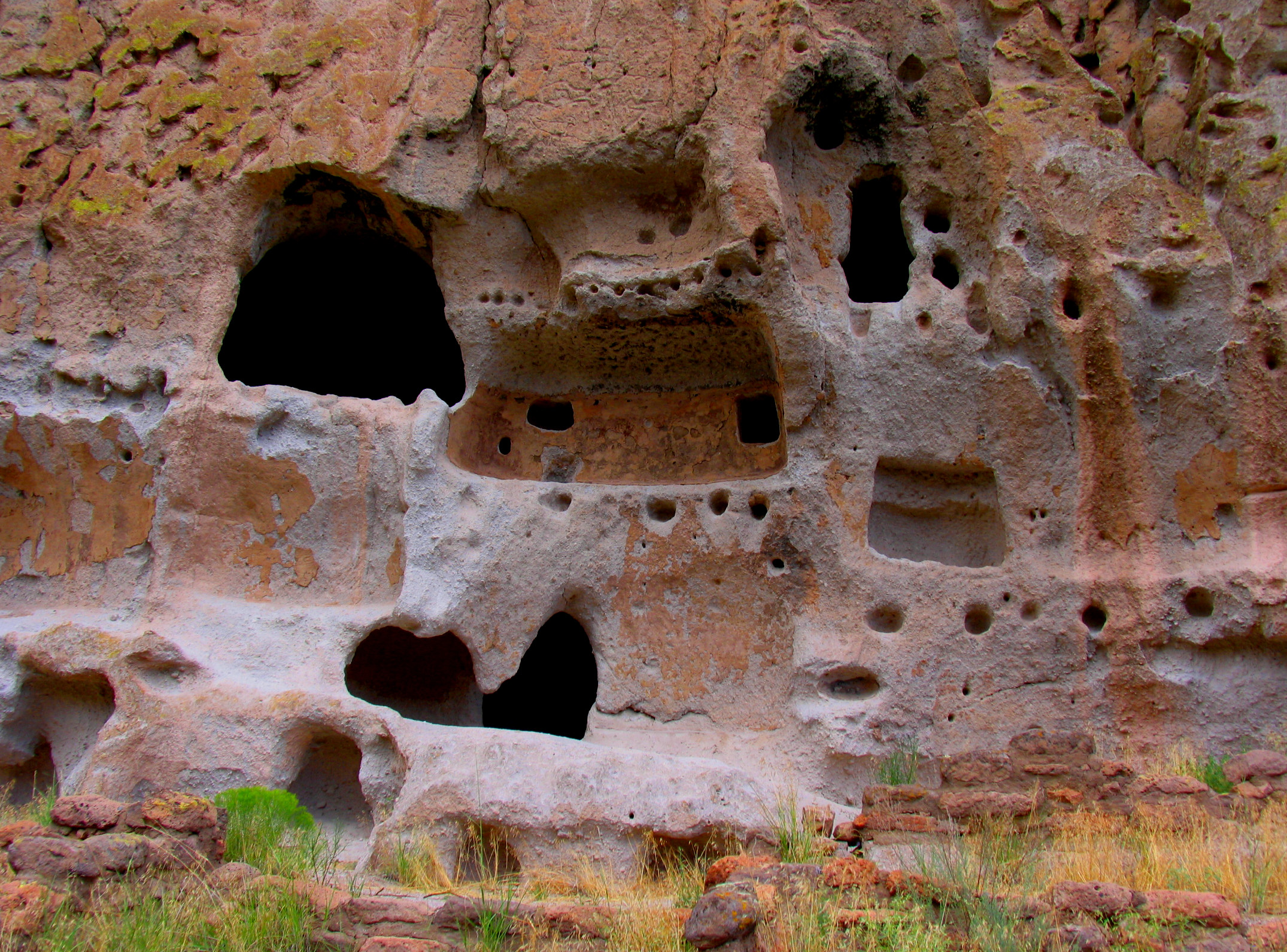
The Canyon Builders
Humans have occupied this area for over 10,000 years, but the permanent settlements that define Bandelier date from around 1150 CE. The builders arrived during a period of intense migration across the Ancestral Puebloan world, driven partly by severe drought and social upheaval in the Four Corners region. In Frijoles Canyon, they constructed Tyuonyi, a circular pueblo that once stood one to three stories tall, with ceiling beams dated by tree-ring analysis to between 1383 and 1466. Nearby Long House stretched along the canyon wall, its rooms supported by the rock itself. The inhabitants carved petroglyphs and painted pictographs, built ceremonial kivas in round, square, and rectangular forms, and participated in a trade network that extended into present-day Mexico. Population peaked around 1500, and by 1600 the canyon was empty. The inhabitants relocated to pueblos along the Rio Grande, including Cochiti and San Ildefonso, which remain occupied to this day.
Preserved in Stone and Timber
President Woodrow Wilson designated Bandelier a national monument on February 11, 1916. The infrastructure that visitors see today was largely built during the 1930s by Civilian Conservation Corps crews, who worked at the site from 1933 to 1941 as part of the New Deal. The 31 buildings they constructed represent the largest assembly of CCC-built structures in any national park area that has not been altered by later additions. Built in the National Park Service Rustic style, using local materials and design traditions, the structures earned designation as a National Historic Landmark district. Over 70 percent of the monument is designated wilderness, where motorized travel and permanent structures are forbidden. The Main Loop Trail from the visitor center passes Tyuonyi, Long House, and a reconstructed Talus House, while a longer trail leads to Alcove House, a shelter cave containing a small reconstructed kiva accessible by ladder.
Secret Neighbors
During World War II, Bandelier's lodge took on an unexpected role. The monument was closed to the public, and the lodge became housing for personnel working on the Manhattan Project at nearby Los Alamos. Scientists and technicians who were secretly building the world's first atomic bomb lived in CCC-built cabins surrounded by 800-year-old cliff dwellings. Construction contractors were housed at the site in early 1944. The juxtaposition is striking: one of the most destructive technologies in human history was developed within walking distance of homes built by people who shaped volcanic rock with hand tools. Today, the Valles Caldera National Preserve adjoins the monument to the north and west, and the monument cooperates with surrounding Pueblo communities, whose ancestors built the structures visitors come to see.
Walking Through Time
Bandelier offers a rare experience: the chance to touch the walls that Ancestral Puebloans carved, to climb ladders into alcoves where families sheltered, and to stand inside reconstructed kivas where ceremonies took place centuries ago. The monument protects archaeological sites across the Pajarito Plateau, from the accessible ruins along Frijoles Canyon to remote backcountry sites reached by rugged trails through canyon and mesa country. Transient waterfalls appear after storms. Painted Cave, deep in the backcountry, preserves Ancestral Puebloan pictographs. The forested mesa tops frame views of the San Miguel Mountains and the Jemez volcanic field. Two-thirds of the monument is wilderness, and the full landscape runs from the Rio Grande at its lowest point to the summit of Cerro Grande on the rim of the ancient caldera that made this place possible.
From the Air
Located at 35.78°N, 106.32°W on the Pajarito Plateau in the Jemez Mountains, near Los Alamos, New Mexico. Elevations range from the Rio Grande to over 10,000 feet at Cerro Grande. Frijoles Canyon is the primary feature, cutting through the volcanic tuff plateau. The monument is adjacent to Los Alamos National Laboratory and the Valles Caldera National Preserve. Nearest airport: Los Alamos Airport (KLAM) approximately 5 nm north. Santa Fe Municipal Airport (KSAF) approximately 25 nm southeast. Mountain terrain with variable weather; best viewed in clear conditions at moderate altitude.