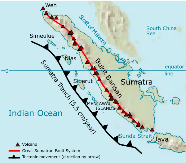
Barisan Mountains
Seventy-four thousand years ago, a volcano in northern Sumatra detonated with enough force to blanket South Asia in ash, plunge global temperatures by several degrees, and -- some scientists argue -- nearly drive humanity to extinction. The caldera it left behind filled with water and became Lake Toba, 100 kilometers long and 30 kilometers wide. That supervolcano is just one of 35 active volcanoes along the Bukit Barisan, the mountain range whose name in Malay means simply "row of hills." The understatement is spectacular.
Sumatra's Burning Backbone
The Barisan Mountains run nearly 1,700 kilometers down Sumatra's western flank, from Aceh in the north to Lampung in the south. It is one of the longest volcanic chains on Earth, and one of the most active. The range owes its existence to the collision of tectonic plates offshore, where the Australian plate dives beneath the Sunda plate along the Sunda megathrust. That subduction generates the magma that feeds the chain's volcanoes, and the oblique angle of convergence has also produced the Great Sumatran Fault -- a massive strike-slip fault system that runs parallel to the mountains and regularly unleashes powerful earthquakes.
Mount Kerinci, the range's highest peak at 3,800 meters, is itself an active stratovolcano. Dense jungle smothers the slopes below the summit, giving way to Sumatran tropical pine forests at higher elevations. The combination of volcanic soil, equatorial rainfall, and altitude creates some of the most biologically rich terrain in Southeast Asia.
The Toba Catastrophe
No discussion of the Barisan Mountains can avoid Toba. Roughly 74,000 years ago, the eruption rated a maximum 8 on the Volcanic Explosivity Index -- the highest level the scale allows. It ejected an estimated 2,800 cubic kilometers of material, created a caldera that would become the world's largest volcanic lake, and deposited ash as far away as the Indian subcontinent. The "Toba catastrophe theory" suggests the eruption triggered a volcanic winter that reduced the global human population to perhaps a few thousand breeding pairs, creating a genetic bottleneck still visible in our DNA.
Today Lake Toba is serene, a popular tourist destination ringed by green hills. Samosir Island sits in the middle of the lake, itself nearly the size of Singapore. The contrast between the lake's tranquility and the violence that created it is one of the great juxtapositions in natural history.
A Restless Chain
Toba may be the most dramatic, but the Barisan range is restless along its entire length. Mount Sinabung, dormant for four centuries, roared back to life in 2010 and has erupted repeatedly since, most recently in March 2021. Mount Marapi, often confused with the more famous Merapi on Java, is one of Sumatra's most active volcanoes. Sibayak offers hikers the surreal experience of walking across steaming fumaroles at its summit crater.
Farther south, the chain continues through Kerinci, Dempo, and Kaba before reaching the calderas of Suoh and Hulubelu near the island's southern tip. The Bukit Barisan Selatan National Park protects some of the last remaining lowland and montane rainforest in the southern range, providing critical habitat for Sumatran tigers, rhinoceroses, and elephants -- three species whose survival depends in part on the rugged inaccessibility these volcanic mountains provide.
Fire Underfoot
Living along the Barisan Mountains means living with the knowledge that the ground is not finished moving. The Great Sumatran Fault, divided into 20 geometrically distinct segments, produces earthquakes regularly. The 1943 Alahan Panjang sequence reached magnitude 7.7, and the 1994 Liwa earthquake devastated southern Sumatra. Villages cluster in the fertile valleys between peaks, farming volcanic soil that is among the most productive on Earth -- the same soil that exists only because eruptions deposited it there.
This is the bargain that volcanic regions everywhere impose: extraordinary fertility in exchange for existential risk. Coffee, rubber, and palm oil thrive in the rich volcanic earth of the Barisan foothills. The farmers who tend these crops work within sight of summits that have erupted within living memory. The row of hills, it turns out, is also a row of warnings.
From the Air
The Barisan Mountains run the entire western length of Sumatra, centered approximately at 3.0S, 102.25E. The range is visible from any flight over or near Sumatra, with peaks rising to 3,800 meters (Mount Kerinci). Major airports along the range include Sultan Thaha Airport in Jambi (WIPA), Minangkabau International Airport near Padang (WIPT), and Fatmawati Soekarno Airport in Bengkulu (WIPL). Expect orographic cloud buildup along the western slopes, especially in the afternoon. Lake Toba is a dramatic landmark visible from high altitude in the northern section. Exercise caution with terrain clearance -- many peaks exceed 3,000 meters.