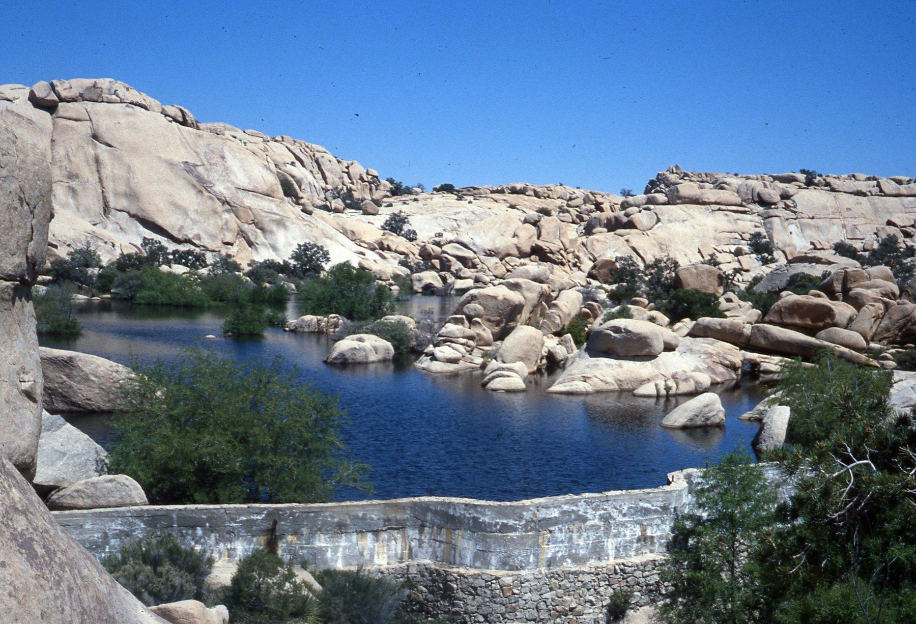
Barker Dam
Water is the organizing principle of the desert, and the cattlemen who ran cattle through what is now Joshua Tree National Park understood this as clearly as the bighorn sheep did. Around 1900, a rancher named C.O. Barker and his partners built a dam in the rocky terrain between Queen Valley and the Wonderland of Rocks, impounding water that would otherwise run off and disappear into the sand. Over a century later, that impoundment still fills after rains, and the wildlife that drink from it follow the same logic Barker's cattle did: go to where the water is.
The Cattlemen's Calculation
The dam Barker and his partners constructed around 1900 was a practical structure rather than an ambitious one — a barrier built in a natural rocky basin to catch and hold water in a landscape that offered little of it. The location between Queen Valley and the Wonderland of Rocks was chosen because the geography cooperated: the boulder formations channeled runoff toward a natural collection point, and the rock walls of the basin reduced the amount of engineered construction required. The dam worked, and the water it held became a reliable resource for the cattle operations that ranged through this part of the desert. The area was still open range, years before the national monument designation that would eventually become Joshua Tree National Park.
Keys Raises the Bar
William F. Keys acquired the ranch in the 1910s and operated it for decades, becoming one of the most consequential figures in the history of what is now the national park. Between 1949 and 1950, Keys raised the height of Barker Dam, increasing its storage capacity and the reliability of the water supply it provided. Keys's modifications are the version visitors see today — the original cattlemen's structure, enlarged by a man who spent nearly five decades making a life in this desert by improving every resource he could find. The dam is now listed on the National Register of Historic Places, recognized both for its engineering history and for its association with the broader story of early settlement in the Mojave.
Petroglyphs in the Rock
Near the dam, Native American rock art marks the boulders that have stood here for far longer than any ranching operation. The petroglyphs are evidence of the deeper human history of this landscape — of people who understood the value of water in the desert and marked the places where it could be found. The relationship between the petroglyph sites and the dam's water storage is not coincidental: the same features that made the location valuable to Barker's cattle made it valuable to the people who lived in this landscape before the cattle arrived. Rock art at Joshua Tree's water sources is a recurring pattern, a reminder that the desert's history of human presence runs long.
The Loop Trail at Dusk
The 1.5-mile loop trail to Barker Dam is one of the most popular short walks in Joshua Tree National Park, and it earns that popularity through the variety it offers: the boulder terrain of the Wonderland of Rocks, the open basin where the dam sits, and the wildlife that the water continues to attract. Bighorn sheep come down to drink from the impoundment. Birds congregate at the water's edge. The light in late afternoon, when the boulders catch the low desert sun and the water reflects it back, produces the conditions that photographers chase across Joshua Tree's varied landscapes. What began as a cattleman's water storage project has become, without anyone planning it, one of the most visited spots in a national park.
From the Air
Located at 34.031°N, 116.146°W in the interior of Joshua Tree National Park, Barker Dam sits within the Wonderland of Rocks — one of the most recognizable geological features visible from the air in the park. The boulder-field landscape appears from altitude as a chaotic jumble of large granite formations against the sandy valley floors. The Wall Street Mill site is nearby. Nearest airports: KPSP (Palm Springs International, approximately 30 miles south-southwest), KTNP (Twentynine Palms, approximately 15 miles east-northeast). The park's distinctive Joshua tree forests are visible as a distinctive textured green at lower altitudes.