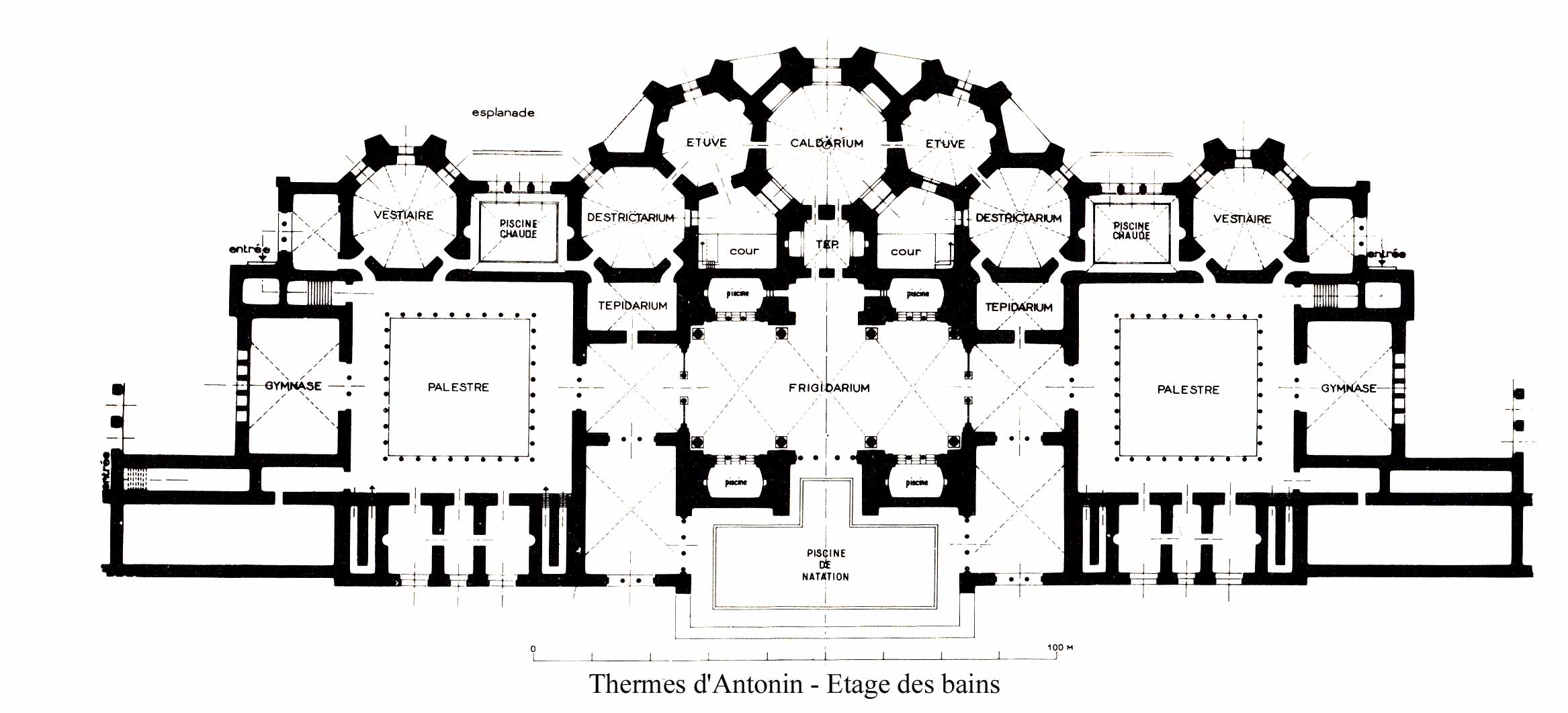
Baths of Antoninus
A single column stands at the Baths of Antoninus, re-erected during a UNESCO campaign in the 1980s. It is one column from the frigidarium, the cold-water hall, and it reaches high enough to suggest what has been lost: vaults that once soared 29 meters overhead, the height of a six-story building. The ruins stretch more than 200 meters along the Carthage shoreline, and even in their ruined state they constitute the largest Roman bathing complex ever built on the African continent -- a structure so massive that centuries of quarrying could not entirely erase it.
Engineering Against the Earth
Roman bathhouses typically placed their service areas -- furnaces, water channels, slave quarters -- in basements beneath the bathing halls. At Carthage, the soft Mediterranean clay along the shoreline made this standard approach impossible. The foundation could not support underground chambers without risking subsidence. The designers adapted by raising the entire structure, building the service level at ground height and the bathing rooms above. This made the Baths of Antoninus taller than comparable complexes elsewhere in the empire, turning an engineering constraint into architectural grandeur. The solution required a larger foundation footprint and more ambitious structural engineering, but it gave the baths something no underground service level could: views of the Mediterranean from the bathing halls above.
Imperial Ambition in Africa
Construction began under Emperor Hadrian and the baths were completed during the reign of his successor, Antoninus Pius, whose name they bear. An inscription dates their active use from 133 to 139 AD, though they were expanded in the 3rd century as Carthage grew into one of the wealthiest cities in the Roman world. Located at the southeastern edge of the archaeological site, near the modern Presidential Carthage Palace, the baths were part of a broader Roman hydraulic system that brought water from Zaghouan, 60 kilometers away, through one of the longest aqueducts in the empire. The Tunisian government proposed this entire hydraulic complex as a future World Heritage Site in 2012.
Centuries of Use and Destruction
The baths served the population of Roman Carthage for nearly three centuries, surviving until the Vandal invasion of 439 AD brought their active use to an end. Even after the Vandals, the building endured in some form -- damaged, repurposed, gradually dismantled. An earthquake in the 4th century required restorations, and the collapse of part of the frigidarium vaults at the end of the 4th or beginning of the 5th century did not immediately end the building's use. Final abandonment came around 638 AD, according to the archaeologist Alexandre Lezine. After that, the baths became what so much of Carthage became: a quarry. For centuries, stone and marble from the complex found their way into mosques in Tunis, churches in the northern Mediterranean, and lime kilns that consumed what could not be carted away.
What Remains
Archaeological excavations began during the Second World War and led to the creation of an archaeological park around the monument. Today, only the ground-floor service spaces near the shore survive from the original structure -- a labyrinth of vaulted corridors and chambers that once housed furnaces, water systems, and the labor that kept the baths running. The Mediterranean Sea has risen by about fifty centimeters since antiquity, swallowing the ancient swimming pool and part of the seaside foundations. Punic tombs, predating the Roman construction by centuries, dot the surrounding park, a reminder that this shoreline has been occupied continuously for nearly three millennia. The baths are now part of the UNESCO World Heritage Site that encompasses the entire Carthage archaeological zone -- Africa's largest Roman ruin, reduced to its bones but still conveying the scale of what Roman Carthage achieved.
From the Air
Located at 36.85°N, 10.34°E along the Carthage shoreline, immediately north of the Presidential Carthage Palace. The ruins are visible from altitude as a large archaeological park along the coast. The re-erected column of the frigidarium serves as a ground-level landmark. Tunis-Carthage International Airport (DTTA) is approximately 4 km to the southwest. Best viewed at 1,500-3,000 feet to see the relationship between the ruins, the modern palace, and the Mediterranean shore.