Batopilas, Chihuahua
In 1632, a Spanish explorer found silver in the Rio Batopilas. The ore was pure white and glistening, bright enough to name the mine Nevada, the snow-capped one. Nearly four centuries later, the town that grew around that discovery still clings to the narrow valley floor at the bottom of Copper Canyon, elevation 578 meters, reachable by a five-hour bus ride down a road that was not paved until 2016. Batopilas has been spectacularly wealthy and crushingly poor, sometimes within the same decade, and its history reads like a parable about what silver does to the places it is found.
Bachotigori, Place of the Enclosed Waters
The Raramuri people, whom the Spanish called Tarahumara, knew this canyon long before any European arrived. They called it Bachotigori, meaning "place of the enclosed waters," a description that captures the geography precisely: the town stretches five kilometers along the right bank of the river in the narrowest part of a canyon walled by near-vertical rock. Batopilas is a mangled Spanish rendering of that indigenous word. The Raramuri had known about the silver for a long time, but it held no particular value for them. When the Spanish saw the white ore glinting in the riverbank, they saw something else entirely.
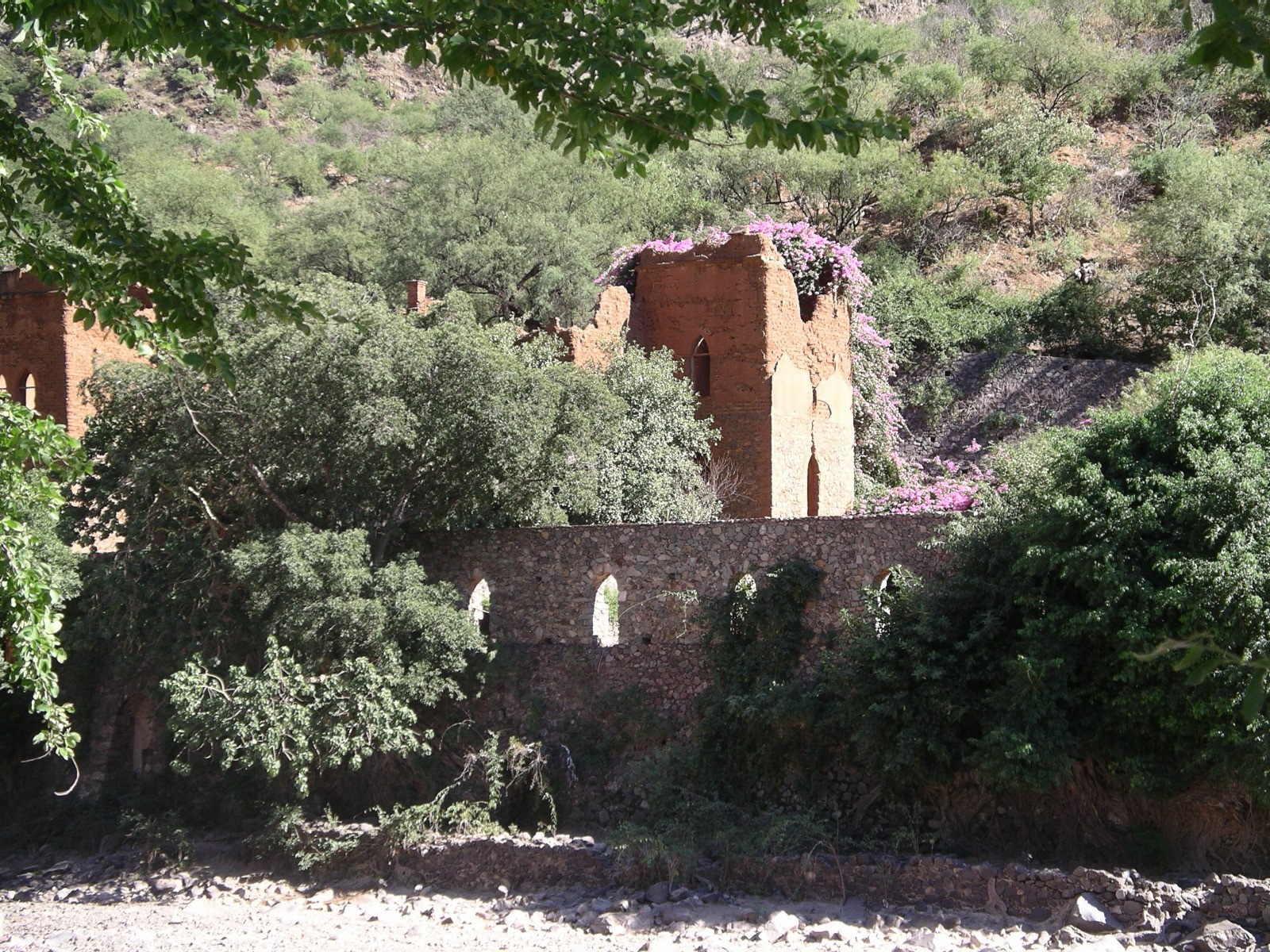
The Hacienda and Its Masters
Batopilas was officially founded in 1708 when Pedro de la Cruz filed a claim on the Guadalupe mine. The Hacienda San Miguel, the town's most prominent structure, rose thirty feet above the river opposite the town center, rebuilt in the 1740s by Don Juan Jose de Rivolta into a medieval-style castle with guard towers and defensive walls. When Rafael Alonzo Pastrana took control, he discovered veins so rich that between 1730 and 1750 the Pastrana deposit produced an estimated 48 million pesos, making its owner one of the wealthiest men in the world. Don Angel Bustamante followed, extracting over 30 million pesos from the Carmen mine between 1790 and 1820. Then came the Wars of Independence, and Batopilas emptied. By 1840, only ten families remained.
The Governor Who Cooked the Books
Alexander Shepherd, the former governor of Washington, D.C., bought the Batopilas mines in 1879 for $600,000. He replaced local officials with Americans loyal to him, eliminated organized banditry, extended mining tunnels, laid rail for mule-drawn ore cars, and used his friendship with President Porfirio Diaz to gain control of 132,779 acres. By 1887, the population had swelled to 6,500. Shepherd built bridges, aqueducts, roads, and a hydroelectric plant that made Batopilas the second city in Mexico, after Mexico City, to have electricity. But after Shepherd's death in 1902, auditors discovered he had wildly overestimated expenses. Ore hauling costs dropped by half once his accounting disappeared. Labor costs he reported to the government at $390 per worker per year were recorded in his personal notes at $75. Most miners rarely lived past 40, many succumbing to silicosis in tunnels where safety was never a priority.
Revolution and Silence
The Mexican Revolution of 1910 drove out the Americans. Pancho Villa's forces controlled northern Mexico, making silver transport impossible. The mines closed officially in 1921. The company's land was divided among the people of the canyons as part of Mexico's agrarian reform -- 670,000 acres distributed to 2,369 families, though nearly all of it was suitable only for goat grazing. By the mid-1930s, barely 400 people remained. In 1940, a massive flood destroyed Shepherd's hydroelectric plant, and Batopilas lost electricity. It would not have power again until 1989. A one-lane dirt road connecting the town to Creel was not completed until 1978. For decades, Batopilas existed in a kind of suspended animation, cut off from the world by the same canyon walls that had once made it fabulously rich.
The Lost Mission and What Endures
Five miles southeast of town, the Mission Angel Custodio Satevo sits in extraordinary isolation, built by Jesuits between 1760 and 1764, abandoned after their expulsion in 1767, and largely neglected until restoration began in 2006. Locals call it the Lost Mission, and reaching it still requires walking a dirt road through the canyon bottom. In Batopilas itself, the ruins of Hacienda San Miguel stand across the river, occupied now by a small hotel and a few families who give tours for a modest fee. The Museo de Batopilas displays artifacts from the mining era. The government declared Batopilas a Pueblo Magico in 2012, a recognition of what the place offers: not prosperity, but a kind of haunted beauty, the canyon walls pressing close, the river running silver in the afternoon light, and the ghosts of fortunes made and lost echoing off the rock.
From the Air
Located at 27.03N, 107.74W at the bottom of a deep canyon in the Copper Canyon system, elevation 578 meters. Batopilas is not visible until nearly overhead due to the canyon depth -- the rim towers more than 1,200 meters above the town. No nearby airports; the closest is Creel, reachable by a winding mountain road. Best viewed by flying along the canyon at 8,000-10,000 feet AGL, looking down into the narrow valley. The Hacienda San Miguel ruins and the town's linear layout along the river are visible from directly above. The Lost Mission at Satevo is 5 miles southeast along the canyon floor.