Battle of Aberdeen (1644)
The drummer was killed on his way back. Montrose had sent him forward under a flag of truce to demand Aberdeen's surrender, and one of the Aberdeen magistrates had even given the boy a coin worth six pounds Scots. But as the party returned to Royalist lines, a trooper from the Fife regiment opened fire, killing the drummer. According to the accounts that survived, the Marquess of Montrose was so enraged that he ordered an immediate assault and gave his soldiers permission to sack the town. What followed on 13 September 1644 was a military victory that destroyed its own purpose.
A Depleted Army Arrives
Montrose had already won one battle that month, defeating government forces at Tippermuir outside Perth, but he could not hold his gains. Highland troops melted away with their plunder, and a stronger force under the Marquess of Argyll was closing from the west. Montrose moved north with roughly 1,500 Irish infantry under Alasdair Mac Colla, a handful of Keppoch clansmen, and about 80 horsemen, hoping to recruit among the Marquess of Huntly's tenants in Aberdeenshire. Instead, he found another Covenanter army blocking his path. The government had ordered militia from the Mearns, Aberdeenshire, and Banffshire to assemble at Aberdeen by 10 September, but only local contingents had arrived -- some 2,000 infantry and 300 cavalry under Lord Balfour of Burleigh.
Two Hours on the Ridge
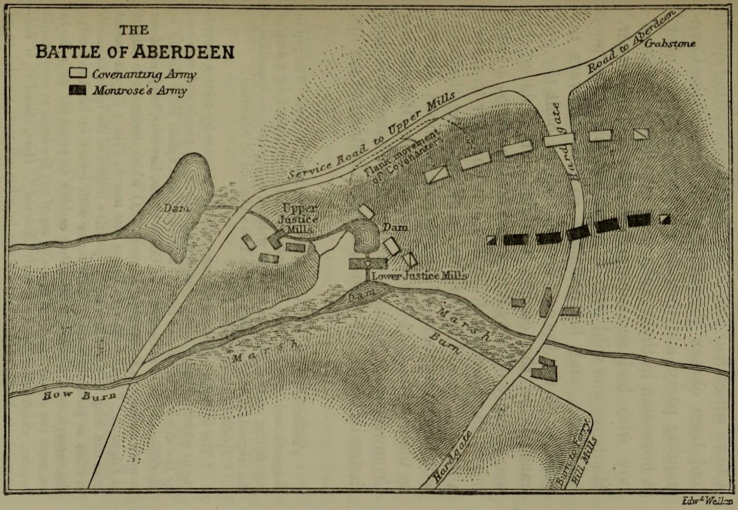
Burleigh's Covenanters took a strong defensive position on a steep ridge above the How Burn valley, southwest of the town. Montrose arranged his outnumbered force in an extended line. The battle opened with a Covenanter cannonade, and the fighting quickly became a series of tactical gambits. On the Royalist left, Captain Mortimer's Irish musketeers repulsed a cavalry charge with a devastating volley. When Craigevar's horsemen rode downhill against O'Cahan's regiment, the Irish simply parted ranks, fired into the cavalry's backs, and let Gordon's horse finish the rout. The decisive moment came when Laghtnan's Irish regiment charged uphill near the ancient Crabstane of Aberdeen. The Aberdeen Militia broke and fled into the town, triggering a general collapse. Government casualties reached roughly 520; Royalist losses were thought to be light. The whole affair lasted about two hours.
The Sack That Changed Everything
What followed the battle was worse than the battle itself. Royalist troops pursued fleeing soldiers into Aberdeen and turned on the civilian population. The chronicler John Spalding, who witnessed the events, recorded days of looting and violence. Women were assaulted. At least 118 people were killed according to Spalding's count -- possibly as many as 160 by the reckoning of Alexander Jaffray, another eyewitness -- including three town councillors and many ordinary tradesmen and residents. Desperate Aberdonians began wearing twists of oats in their bonnets, the Royalist badge, hoping to pass as allies. It made little difference. Spalding noted bitterly that the disguise offered scant protection.
Victory That Poisoned Its Own Cause
The tragedy was compounded by irony. Aberdeen had been broadly sympathetic to the Royalist cause before Montrose arrived. After three days of occupation and abuse, that sympathy was destroyed. Montrose left for the Highlands to recruit and avoid the approaching Argyll, but he would find no volunteers in Aberdeenshire. The sack of Aberdeen became one of the defining atrocities of Scotland's civil war, remembered in contemporary accounts, novels, and local memory. Today, the battlefield site lies beneath the parkland of Bon Accord Terrace Gardens. The ridge where Burleigh's men made their stand is now a gentle slope of grass. Justice Mill Lane, where the surrender ultimatum was delivered and rejected, is a modern street. The violence of September 1644 left no visible scars on the landscape -- only on the historical record.
From the Air
The battlefield was located southwest of Aberdeen's city centre, in the area now occupied by Bon Accord Terrace Gardens and Justice Mill Lane (57.14N, 2.11W). The site is entirely urbanised and not distinguishable from the air. Nearest airport: Aberdeen (EGPD), approximately 5 miles northwest.