Battle of Averasborough
Three days before the largest Civil War battle ever fought in North Carolina, there was a rehearsal. On March 16, 1865, on the muddy grounds of a plantation called Oak Grove near present-day Erwin, Confederate Lt. Gen. William J. Hardee threw his corps against the left wing of William T. Sherman's army, trying to buy time for Gen. Joseph E. Johnston to assemble a force large enough to stop Sherman's relentless march north. It did not work. Each side lost about 700 men, Hardee's troops withdrew before nightfall, and three days later the two armies collided again at the Battle of Bentonville in one of the war's final major engagements. Averasborough was the opening act -- brief, bloody, and ultimately unable to change what was coming.
Sherman's Two Columns
By March 1865, Sherman's army was deep into North Carolina, moving north toward Goldsboro in two widely separated columns. The right column, the Army of the Tennessee under Maj. Gen. Oliver O. Howard, advanced along one route while the left column, the Army of Georgia under Maj. Gen. Henry W. Slocum, marched along another. The gap between the two wings was deliberate -- it allowed Sherman to forage across a wider swath of countryside -- but it also created a vulnerability. Confederate Gen. Joseph E. Johnston saw an opportunity. If he could strike one wing before the other could reinforce it, he might inflict a serious blow. He ordered Hardee to hit Slocum's column while it was isolated.
The Plank Road Fight
Slocum's troops had crossed the Cape Fear River at Fayetteville and were marching north up the Raleigh plank road when they ran into Hardee's corps dug in near Averasborough. On the morning of March 16, troops from the Union XX Corps under Maj. Gen. Alpheus S. Williams pushed forward and were driven back by a sharp Confederate assault. But Union reinforcements arrived quickly. The Federal counterattack rolled over two Confederate defensive lines before grinding to a halt against a stubborn third. As units from Maj. Gen. Jefferson C. Davis's XIV Corps began appearing on the field, the math turned decisively against the defenders. Outnumbered and in danger of being flanked on both sides, Hardee ordered his men to withdraw. The engagement was over by evening.
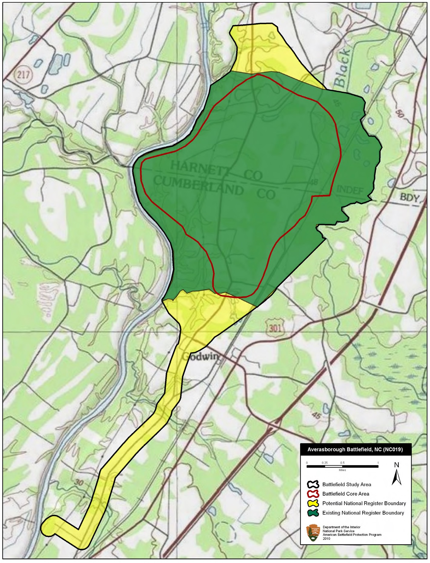
Oak Grove and the Plantation Ground
The battle unfolded across the grounds of Oak Grove, the plantation of the John Smith family, in a landscape of plowed fields, pine woods, and muddy farm roads. Nearby Lebanon plantation was pressed into service as a field hospital, its rooms filled with wounded from both sides. Before the fighting even began, Union soldiers had raided Ellerslie Plantation for supplies and quartered troops in its main house. The diary of Mrs. Jane Evans Elliot, kept from 1837 to 1882, recorded the upheaval of those days. These were not anonymous battlefields. They were someone's home, someone's livelihood, transformed overnight into killing ground and then, just as quickly, left behind as the armies moved on.
Seven Hundred on Each Side
The casualty figures tell the story of a battle that achieved little for either side. Union forces suffered approximately 682 killed, wounded, and missing, while Confederate casualties were estimated between 400 and 500. Hardee had hoped to delay Sherman's advance long enough for Johnston to consolidate Confederate forces for a decisive stand, but the Union column barely broke stride. Slocum's troops resumed their march the next morning. The real confrontation came three days later at Bentonville, where Johnston threw everything he had at Sherman's left wing in what became the last major Confederate offensive of the war. Bentonville, too, ended in Confederate withdrawal. Within weeks, Johnston surrendered his army at Bennett Place near Durham. Averasborough was one of the last gasps of a cause already lost.
Preserved Ground
For more than a century, the Averasborough battlefield was farmland, its significance marked only by local memory and a handful of monuments. In 2001, the Averasboro Battlefield Historic District was listed on the National Register of Historic Places, recognizing the site's role in the final chapter of the Civil War. The American Battlefield Trust and its partners have since acquired and preserved significant acreage of the original battlefield. Oak Grove plantation still stands. The landscape of low-rolling fields and pine forest looks much as it did in March 1865, minus the smoke and the sound of musketry. It is a quiet place now, the kind of ground where you have to know what happened to feel its weight.
From the Air
Located at 35.266N, 78.672W in Harnett County, NC, near the town of Erwin. The battlefield sits along the Cape Fear River floodplain, visible as a mix of agricultural fields and wooded areas. Nearest airport is Harnett Regional Jetport (KHRJ), approximately 10 nm northeast. Fayetteville Regional Airport (KFAY) is about 20 nm south. The terrain is flat to gently rolling Piedmont, with the Cape Fear River visible to the west. Best viewed at 2,000-4,000 ft AGL.