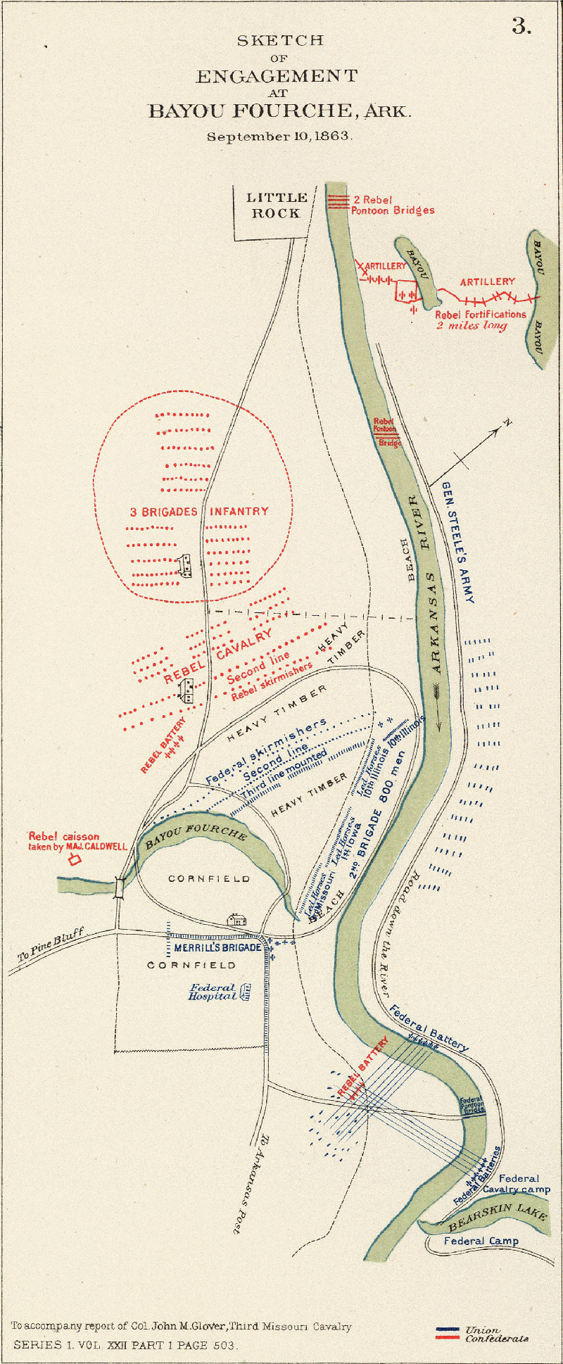
Battle of Bayou Fourche
One of the strangest facts about the fall of Little Rock is that the Confederate officer commanding its defense had recently killed one of his own generals in a duel. Brigadier General John Marmaduke had shot Brigadier General Lucius Walker dead in a personal dispute just weeks before being assigned to hold the bayou approaches to the Arkansas capital. When Colonel Archibald Dobbins, who had served under Walker, learned he would now report to Marmaduke, he refused -- and was placed under arrest. This was the state of Confederate leadership in Arkansas on September 10, 1863, when Union cavalry splashed across the Arkansas River and the last meaningful battle for the state capital began.
After Pea Ridge, After Vicksburg
The road to Bayou Fourche ran through a series of Confederate disasters. The Battle of Pea Ridge in March 1862 shattered Confederate power in northwestern Arkansas. The Battle of Prairie Grove that December confirmed Union control. The fall of Vicksburg on July 4, 1863, freed Union troops for a push into the Arkansas River Valley. Major General Sterling Price, commanding the Confederate District of Arkansas, had about 32,000 men on paper but only 14,500 present for duty. He built fortifications across the Arkansas River from Little Rock, but knew he could only hold the city if the Union attacked his defenses head-on. The river was crossable at several points, making a flanking movement almost inevitable.
The Pincer Along the River
Major General Frederick Steele commanded the Union advance. He brought about 7,000 infantry from Helena, while Brigadier General John Davidson led approximately 6,000 cavalry from Wittsburg. The two forces joined at Clarendon in mid-August, forming the Army of Arkansas with a combined strength of over 10,000 men. Steele chose not to assault Price's fortifications directly. Instead, his infantry would advance along the north bank while Davidson's cavalry crossed the river to outflank the Confederate works. On the morning of September 10, Confederate batteries fired on the Union pontoon bridge at daybreak but were driven off by return artillery fire. Confederate sharpshooters harassed the bridge builders, but by 11:00 a.m. Davidson's entire division was across. Price, with only 1,250 men opposing the cavalry crossing, began withdrawing from his fortifications.
A Bayou Splits the Battle
Bayou Fourche entered the Arkansas River where the road forked, placing the waterway between the two advancing Union columns. Colonel John Glover sent the 10th Illinois Cavalry north of the bayou while the 1st Iowa Cavalry deployed to the south. The terrain north of the bayou was wooded; south of it, a cornfield fronted the Confederate lines. The bayou created persistent communication problems between the two Union wings -- at one point Colonel Lewis Merrill's men came under fire from their rear, and Merrill feared he was being flanked. Investigation revealed the shots were overshots from Glover's fight on the other side of the waterway. When Shelby's Iron Brigade arrived as reinforcements, enfilade fire from Steele's artillery across the river prevented a Confederate counterattack. Glover's dismounted troopers eventually broke through, sweeping into the rear of the Confederate position. Union losses totaled 72 men; Confederate casualties were never officially reported.
The Capital Falls Quietly
Price had ordered Little Rock abandoned the moment he learned Davidson's cavalry had crossed the river. Bridges, railroad cars, and the gunboat CSS Pontchartrain were destroyed to prevent capture. The state government packed up and relocated to Washington, Arkansas -- a tiny town in the southwest corner of the state that would serve as the Confederate capital of Arkansas for the rest of the war. Price withdrew his forces to Arkadelphia. Davidson's third brigade and the 1st Iowa Cavalry completed the movement into Little Rock against negligible resistance. The Union captured the Little Rock Arsenal and five abandoned cannons. Confederate morale collapsed after the fall of the city, and mass desertions plagued the Southern army throughout the remainder of the campaign. Today, remaining portions of the Bayou Fourche battlefield are threatened by residential development.
From the Air
Located at 34.722N, 92.202W in Pulaski County, near present-day Little Rock and North Little Rock, Arkansas. The battlefield sits in the Arkansas River lowlands east of downtown Little Rock. Bayou Fourche (now Fourche Creek) is still visible winding through the area. Bill and Hillary Clinton National Airport (KLIT) is approximately 3 nm to the southwest. The Arkansas River and its bridges are prominent landmarks. Terrain is flat at approximately 250-300 feet MSL. Best viewed at 2,000-3,000 feet AGL.