Battle of Bear Paw
Poker Joe saw it coming. "Looking Glass, you can lead," he said at the council on September 24, 1877. "I am trying to save the people, doing my best to cross into Canada before the soldiers find us. You can take command, but I think we will be caught and killed." Ten days later, Poker Joe lay dead on this Montana hillside, shot by a Nez Perce sharpshooter who mistook him for a Cheyenne scout. The Canada border waited just 40 miles north.
A Thousand Miles of Running
The Nez Perce began their journey in June 1877, fleeing forced relocation from their ancestral lands in north-central Idaho Territory. What started as resistance became one of the most remarkable fighting retreats in military history. Some 800 people, including fewer than 200 warriors, crossed Idaho, Montana, and Wyoming, navigating the Rocky Mountains, passing through Yellowstone National Park, and fighting off or evading every army unit sent against them. By late September, they had covered more than a thousand miles. An army surgeon tracking them admitted, "I am actually beginning to admire their bravery and endurance in the face of so many well-equipped enemies."
The Fatal Delay
After the Battle of Canyon Creek on September 13, the Nez Perce seemed safe. General Oliver Howard's forces lagged far behind. But the exhausted people paused at Cow Island Landing on the Missouri River, raiding stockpiled supplies and losing a crucial day. Unknown to them, Colonel Nelson Miles was racing northwest from Fort Keogh with 520 soldiers. Miles crossed the Missouri and swung north of the Bear Paw Mountains, keeping his approach hidden. When Looking Glass advocated rest for the weary travelers, Poker Joe urged speed. Looking Glass prevailed. The Nez Perce moved toward Canada in slow stages, watching the south for Howard's soldiers, unaware that Miles was closing from the southeast.
Five Days of Siege
Miles attacked on September 30 at 9:15 AM. The cavalry charge killed several Nez Perce leaders, including Chief Joseph's brother Ollokot and the war chief Toohoolhoolzote. The 7th Cavalry suffered the heaviest casualties, losing 16 dead and 29 wounded out of 110 men. By nightfall, 18 soldiers and 22 Nez Perce lay dead. Miles surrounded the camp, but charging the entrenched positions proved suicidal. Snow fell as both sides dug in. Looking Glass died during the siege, raising his head above a rock to see what he thought were approaching Lakota reinforcements. A sniper's bullet killed him instantly.
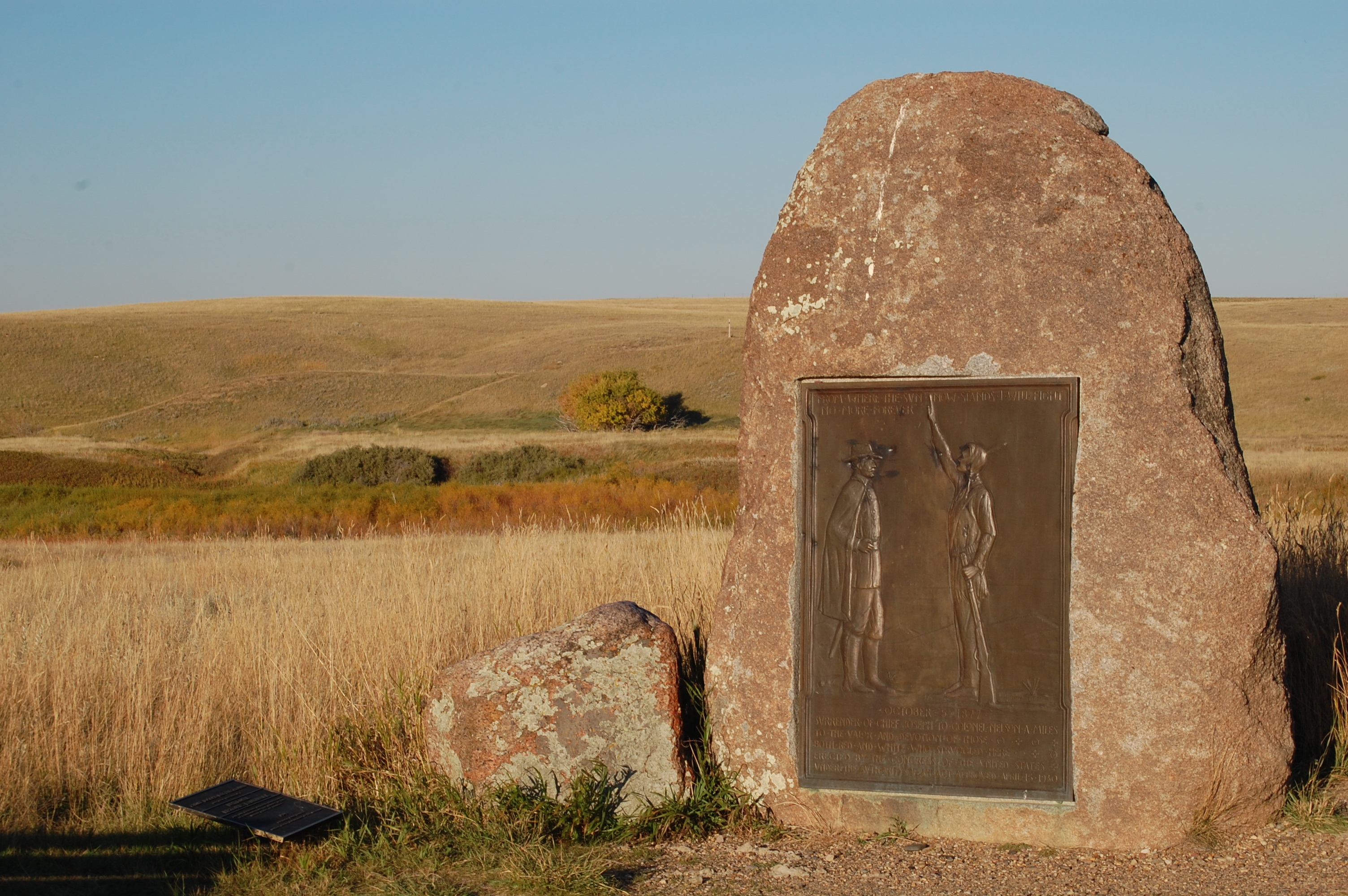
Words That Echo
On October 5, two Nez Perce intermediaries promised that the survivors would not be executed and would return to their Idaho homeland. With these assurances, Joseph surrendered. White Bird and perhaps 233 others slipped through army lines and reached Canada, where Sitting Bull's Lakota received them. Joseph never saw his homeland again. The army sent the captives to Kansas, then to Indian Territory, despite protests from Miles and Howard. When Joseph finally returned to the Pacific Northwest in 1885, authorities refused him entry to the Wallowa Valley in Oregon. He died in 1904 on the Colville Reservation in Washington. His doctor said he died of a broken heart.
The Ground Remembers
The Bear Paw Battlefield remains much as it was in 1877, a rolling expanse of Montana grassland where coulees and ridges determined who lived and who died. The National Park Service manages the site as part of Nez Perce National Historical Park. In 1935, a survey team that included Nez Perce veterans of the battle mapped the ground. The site became a National Historic Landmark in 1988. The Blaine County Museum in nearby Chinook houses artifacts from the battle, and visitors can arrange joint tours of the museum and battlefield. The silence here carries weight. Forty miles from freedom, the running stopped.
From the Air
Located at 48.38°N, 109.21°W in Blaine County, Montana, approximately 16 miles south of Chinook on County Route 240. The battlefield sits on rolling prairie at the northern edge of the Bear Paw Mountains. Best viewed at 3,000-5,000 feet AGL in clear conditions. The terrain shows subtle ridges and coulees that were tactically significant. Nearest airports: Chinook (0S4, grass strip) and Havre City-County Airport (KHVR), approximately 45 miles west. The Canadian border lies 40 miles due north.