Battle of Beecher Island
The sandbar was barely a hundred yards long and perhaps sixty wide, a sliver of sand in the Arikaree River's shallow bed. On September 17, 1868, fifty civilian scouts led by Major George Forsyth splashed across to this unlikely fortress as hundreds of Cheyenne Dog Soldiers and Oglala Sioux warriors closed in from the surrounding bluffs. For the next nine days, these fifty men would dig rifle pits with their bare hands, eat the rotting flesh of their dead horses, and hold off an enemy that outnumbered them perhaps ten to one. The battle that followed would give the island a name still remembered today: Beecher Island, for Lieutenant Fredrick Beecher, who fell in the first assault.
Sheridan's Experiment
By the summer of 1868, the central Great Plains had become a killing ground. Cheyenne and Arapaho warriors, driven by memories of the Sand Creek Massacre and resistance to the transcontinental railroad, had killed 79 settlers in repeated raids across western Kansas. General Philip Sheridan, fresh from the Civil War, faced a problem: his cavalry could not catch small, mobile war parties dispersed across hundreds of miles. His solution was unconventional. He ordered Major George Forsyth, a Civil War veteran, to recruit fifty first-class hardy frontiersmen and arm them with Spencer repeating rifles. These were not soldiers but civilians, selected from the best marksmen and hunters on the plains. Their mission was to fight like Indians, not like the traditional Army.
Walking Into a Trap
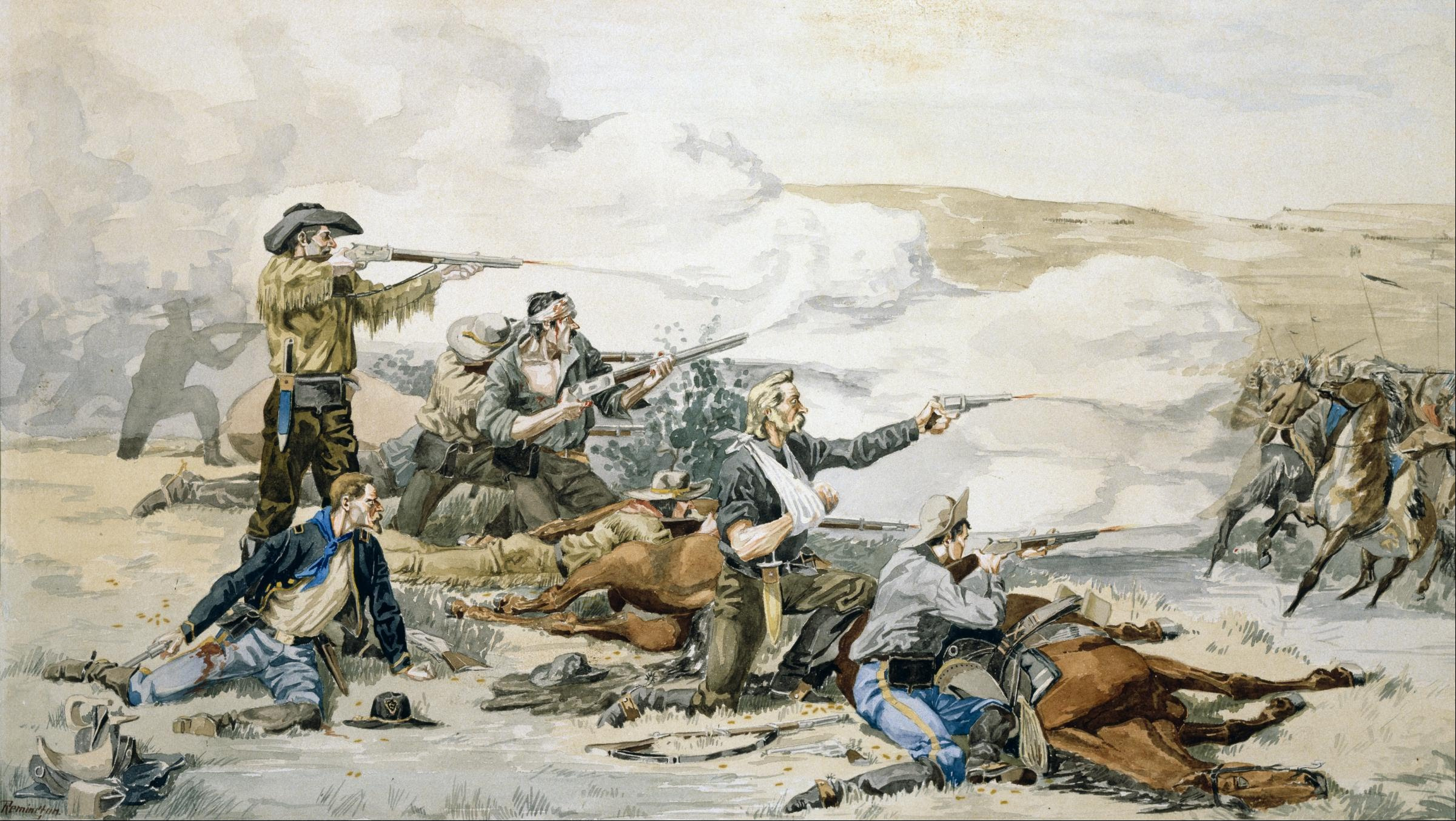
Forsyth's scouts departed Fort Wallace following the trail of raiders into what is now Yuma County, Colorado. The trail grew heavier, wider, the sign of a force far larger than the twenty-five warriors they sought. Forsyth pressed on. At dusk on September 16, they made camp on the south bank of the Arikaree River, not knowing they had stopped just downstream from a massive encampment of Cheyenne Dog Soldiers led by the legendary warrior Roman Nose, along with Lakota and Arapaho lodges. By morning, hundreds of warriors had positioned themselves among the bluffs. When eight warriors attempted to stampede the scouts' horses, Forsyth heard the war cries and ordered his men to the sandbar. They tied their horses to bushes to form a barricade, dug shallow pits with knives and tin cups, and waited.
Nine Days of Desperation
The Spencer rifles proved devastating. Their rapid fire cut down the first mounted charges, surprising warriors accustomed to single-shot weapons. But Lieutenant Beecher fell in the early fighting, and Forsyth took bullets to both legs and his skull. By the second day, all the horses were dead, and the men began eating their flesh. By the fourth day, the meat had spoiled, making the scouts violently ill. Forsyth, his wounds festering, asked his men to extract a bullet from his leg. When they refused, he used his own razor. On the first night, scouts Jack Stilwell and Pierre Trudeau crawled through the grass past Indian lines, beginning a four-day journey to Fort Wallace on foot with nothing but spoiled horse meat for food. They evaded war parties the entire way.
Rescue at Dawn
On September 25, nine days after the battle began, Lieutenant Colonel Louis Carpenter's Troops H and I of the 10th Cavalry, one of the Buffalo Soldier regiments, rode into view at daybreak. The siege was over. Five scouts had died, including Lieutenant Beecher and the surgeon Dr. Mooers. Eighteen more were wounded. The Indian casualties were harder to count, but the scouts' accurate, rapid fire had taken a significant toll, including the death of Roman Nose during one of the charges. The battle proved Sheridan's theory about mobile, well-armed scouts, but it also showed the desperation of both sides in a conflict that would continue for another decade. Today, Beecher Island Battleground is listed on the National Register of Historic Places, a quiet stretch of prairie near Wray, Colorado, where fifty men once held the line.
From the Air
Located at 39.87N, 102.19W near Wray, Colorado, in Yuma County. The battlefield site is on the Arikaree River, a tributary of the Republican River, visible as a ribbon of green through the dry prairie. Best viewed at 1,500-2,500 feet AGL. The sandbar where the scouts made their stand no longer exists in its original form due to river changes, but the memorial site is marked. Nearby airports include Wray Municipal (V07) approximately 10nm north. The surrounding landscape remains open grassland with scattered agricultural fields.