Battle of Courtrai (1918)
For four years the front line in Belgium had barely moved. Wytschaete to Passchendaele to Diksmuide: a few villages traded back and forth at the cost of hundreds of thousands of lives. Then in October 1918 it suddenly began to move very fast. On the morning of 14 October the creeping barrage of the British Second Army rolled forward at 100 yards a minute - far faster than any 1917 advance, faster than the infantry could comfortably keep up with - because the Allies had finally guessed correctly that the German army on the other side of it could no longer hold. Five days later they were in Kortrijk. The war had nineteen days left.
A King at the Head of Three Armies
The force assembled in Flanders for the final push was unusual. Twelve divisions of the Belgian Army, ten British divisions of the Second Army, and six French divisions of the Sixth Army made up the Groupe d'Armees des Flandres - a combined Allied command under King Albert I of Belgium himself, with the French general Jean Degoutte as his chief of staff. Albert had been a soldier-king through the worst of the war, refusing to leave the strip of Belgium that remained behind his lines. Now, with the Hindenburg Line broken further south and the Germans falling back across the entire Western Front, his moment had come. The Fifth Battle of Ypres in late September had cracked the German Fourth Army. Then the autumn rain and a collapsing supply system had stopped everyone in their tracks for two weeks. By mid-October the GAF was ready to try again.
The Barrage at 100 Yards a Minute
At dawn on 14 October the offensive opened on a front running from Comines on the Lys north to Diksmuide. The British creeping barrage - the wall of shellfire that infantry walked behind - moved at 100 yards a minute, much faster and farther than 1917 doctrine had allowed. The reason was simple: nobody expected serious German resistance any more. The gamble paid off. By evening, British infantry had taken the high ground dominating Wervik, Menen and Wevelgem. Further north, Moorslede fell. Belgian troops reached Izegem; French infantry surrounded Roeselare; Belgians took Kortemark. The map, which had been a static cartographic ulcer for four years, was suddenly redrawing itself by the hour.
Towns Falling Like Dominoes
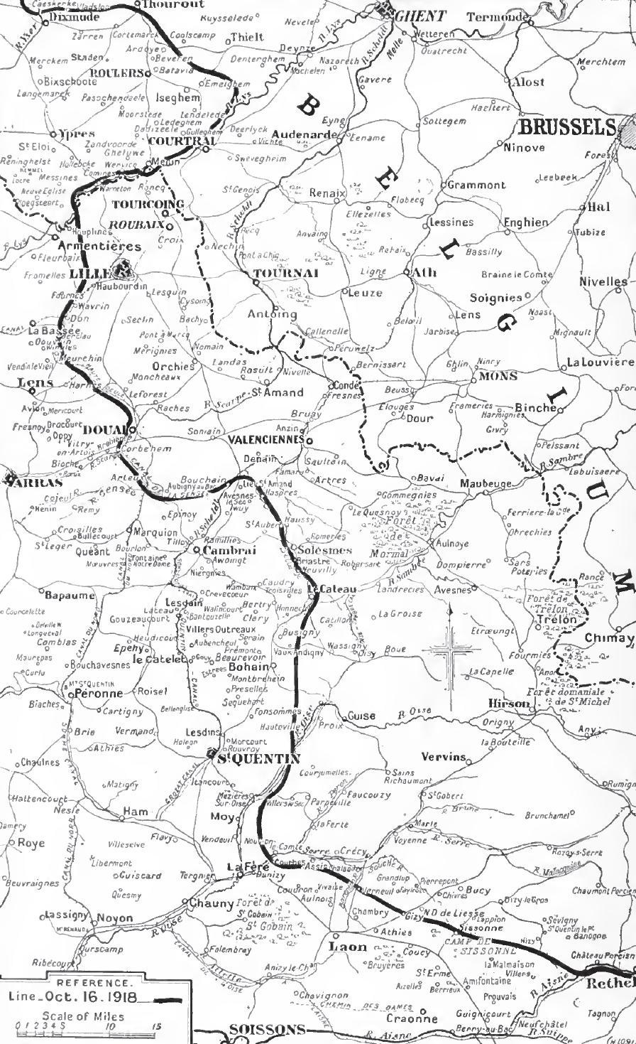
On 15 October, Roeselare fell. By the 16th the British held the north bank of the Lys all the way up to Harelbeke and had crossed it at several points. The 17th was a roll call of liberation: Torhout, Ostend, Lille, Douai - all back in Allied hands by sundown. Bruges and the U-boat port of Zeebrugge fell on 19 October, the same day that men of the British Second Army crossed the Lys and walked into Kortrijk itself. Four years of German occupation ended in a single afternoon. By the 20th the Dutch border had been reached. By the evening of 22 October the Allied line ran along the Scheldt from Valenciennes north to Avelgem. The advance had moved Allied positions an average of 45 miles east in a little over a week.
The Last Cavalry Charge
On the same 19 October that Kortrijk was retaken, in a small action north-east of Bruges, two squadrons of Belgian cavalry under Major Victor Van Strydonck met retreating Germans near the village of Burkel. The Belgians drew sabres and charged. It was a brief and bloody business and it succeeded, and history records it as the last cavalry charge in Western Europe. There is something fitting about it: a war that had begun with German Uhlans and French cuirassiers riding in burnished helmets in 1914, that had then sunk into the industrialised slaughter of the trenches, ended at the gallop in a Flemish potato field, with horses again.
What the Armistice Found
Even after Kortrijk fell, the GAF was not done. On 30 October it launched a new offensive across the Lys and the Scheldt that was still rolling forward when the bell rang. The Armistice was signed at Compiegne on 11 November 1918. By that morning the front had moved an average of 45 miles east of the line it had occupied in early October. It ran from Terneuzen on the Dutch coast, along the Scheldt through Ghent and on toward the Somme. Kortrijk was rebuilt. The bridges over the Lys were thrown up new. Today the city is a comfortable Flemish provincial capital, a place of design schools and the famous footbridge over the river - but on every 19 October, the bells still ring for the day in 1918 when the British walked back in and the longest four years in Belgian memory finally ended.
From the Air
Coordinates 50.83 N, 3.27 E - Kortrijk on the Lys (Leie) river, in West Flanders. Nearest airports: Kortrijk-Wevelgem (EBKT) on the western edge of the city, Lille-Lesquin (LFQQ) 25 km south-west, Ostend-Bruges (EBOS) 55 km north-west. From altitude the Lys traces a clear east-west arc through flat farmland; the 1918 advance ran perpendicular to it on a 30-km front from Comines to Diksmuide. Best viewed in clear weather from 5,000-12,000 feet.