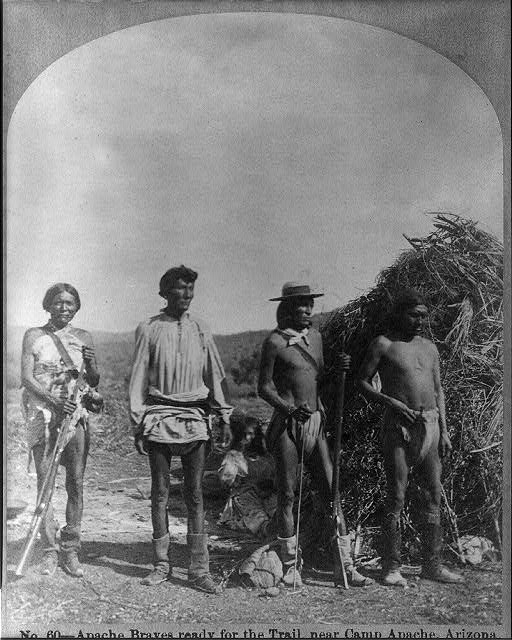
Battle of Fort Apache
Two days earlier and forty miles away, the U.S. Army had killed a medicine man. On September 1, 1881, the consequences arrived at Fort Apache's gates. Dozens of mounted White Mountain Apache warriors descended on the cavalry garrison in eastern Arizona Territory, rifles cracking from long range, volleys echoing off the walls of a fort that suddenly felt very small. The Battle of Fort Apache was not the bloodiest engagement of the Apache Wars, but it proved to be one of the most consequential -- a reprisal attack that helped shatter a fragile peace and push Apache bands across the Southwest toward a final, devastating conflict that would not end for another five years.
The Death That Lit the Fuse
The roots of the attack lay at Cibecue Creek, where on August 30, 1881, soldiers under Colonel Eugene Asa Carr attempted to arrest Nochaydelklinne, a medicine man whose growing influence alarmed the military command. The arrest turned violent, and Nochaydelklinne was killed. The Battle of Cibecue Creek sent shockwaves through the Apache communities of the Fort Apache Reservation. Though some historians view the subsequent attack on Fort Apache as a continuation of the Cibecue Creek engagement, the two events unfolded roughly 40 miles apart on opposite sides of the reservation and two days apart. What happened at Fort Apache was deliberate -- a counterattack born of grief and outrage over the medicine man's death.
Rifles at Long Range
The Apache warriors chose their tactics carefully. Rather than storm the fort directly, they positioned themselves at the extreme end of their rifle range near Whiteriver, Arizona, and fired repeated volleys into the garrison. Colonel Carr's cavalry and their Native allies returned fire, but the Apache maintained their distance throughout the entire engagement, turning the battle into a prolonged exchange of gunfire rather than a close-quarters fight. The shooting continued until sunset, with several Apache charges repulsed by counter fire. When the guns finally fell silent, only three American soldiers had been wounded. Apache casualties remain unknown to this day. Two days later, reinforcements arrived from Fort Thomas on the San Carlos Indian Reservation, but the Apache had already melted into the surrounding mountains.
The War That Followed
The killing of Nochaydelklinne and the siege of Fort Apache sent a clear message to Apache bands across the territory: the reservations were not safe ground. In the weeks and months that followed, Apache groups abandoned their recently established reservations to join Geronimo and other war leaders, or to flee south into northern Mexico. The twin engagements at Cibecue Creek and Fort Apache helped ignite another full-scale Apache war in Arizona Territory, a brutal conflict that dragged on until Geronimo's surrender at Skeleton Canyon in 1886. What had begun as an arrest gone wrong at a creek bed cascaded into five years of warfare across the American Southwest.
A Monument Recognized
The site of Fort Apache endured long after the guns fell silent. In 1998, the World Monuments Fund placed it on the World Monuments Watch, recognizing both its historical significance and its vulnerability. The fund, working with American Express, provided financial support to develop a master plan for preserving the fort's historic buildings. Today, the site sits within the Fort Apache Indian Reservation, administered by the White Mountain Apache Tribe. The buildings that once sheltered cavalry soldiers now stand as quiet witnesses to a conflict that reshaped the American Southwest. The battle itself lasted only hours, but its echoes -- in broken treaties, displaced peoples, and a war that consumed a generation -- carried across decades.
From the Air
The Battle of Fort Apache site is located at 33.791N, 109.989W in eastern Arizona, on the Fort Apache Indian Reservation near Whiteriver. The fort's remaining structures are visible from moderate altitude. Recommended viewing at 2,000-4,000 feet AGL. The nearest airport is Whiteriver (KWHR/E24), immediately adjacent. Terrain is mountainous with pine forests; expect variable winds and weather conditions. The fort's parade ground and historic buildings are identifiable from the air. The site of the Battle of Cibecue Creek lies approximately 40 miles to the northwest.