Battle of Fort Davidson
Sterling Price had thirteen thousand reasons to feel confident as his Army of Missouri crossed into the state in September 1864. The Confederacy was losing the war, but Price believed one bold stroke through his home state could divert Union forces, spark a popular uprising, and tip the presidential election toward George McClellan. What he found instead was a hexagonal earthen fort tucked in a valley between four mountain peaks near Pilot Knob, Missouri, defended by fewer than fifteen hundred men who had no intention of surrendering. The battle that followed on September 27, 1864, lasted only a few hours, but its consequences would chase Price all the way to Texas.
The Valley Between Four Peaks
Fort Davidson sits on a plain surrounded by Pilot Knob, Shepherd Mountain, Rock Mountain, and Cedar Hill. Built in 1863 as a hexagonal earthwork near the base of Pilot Knob, the fort was designed to protect local iron deposits and the St. Louis and Iron Mountain Railroad. Its earthen walls enclosed a powder magazine buried underground. A moat ringed the perimeter. The fort's garrison was a patchwork force: 856 Union regulars, 450 Missouri State Militia men, and 150 armed civilians, all under the command of Brigadier General Thomas Ewing Jr. Ewing knew that if Price captured the fort, the road to St. Louis lay open. He also knew, with cold personal clarity, that surrender was not an option -- Price's Confederates despised Ewing for issuing General Order No. 11 the previous year, which had forcibly depopulated four western Missouri counties.
A Frontal Assault Gone Wrong
Price arrayed five brigades around the valley on the afternoon of September 27, planning simultaneous attacks from multiple directions. The plan fell apart almost immediately. The assaults came piecemeal rather than together, allowing the outnumbered defenders to concentrate their fire on each wave in turn. Brigadier General William Cabell's brigade charged three times. On the third attempt, some of his men actually crossed the moat, only to be driven back by hand grenades hurled from inside the walls. The fort was crammed to twice its designed capacity, and Ewing put this to advantage: one line of soldiers loaded weapons while another line fired, pouring continuous volleys into the advancing Confederates. By nightfall, Confederate casualties numbered between 500 and 1,000. Union losses were 213. Price ordered ladders built overnight for a renewed assault at dawn.
The Great Escape
Ewing had no intention of waiting for morning. Under cover of darkness, the entire garrison slipped out of Fort Davidson, threading past Confederate pickets of Colonel Archibald Dobbins's brigade who were supposed to be blocking the escape route. A trailing detachment detonated the powder magazine. The explosion ripped a crater into the earth that remains visible today. Remarkably, the Confederates neither noticed the evacuation nor reacted to the blast. When dawn came, Price's men discovered an empty fort and a smoldering ruin where the magazine had been. The defenders were already miles away, heading toward Rolla.
A Campaign Undone
The failed assault at Fort Davidson broke something in Price's army. Morale plummeted. The bloody repulse revealed that many of his troops, poorly armed and poorly trained, were not capable of storming even a modest fortification. Price abandoned his plan to attack St. Louis. When he reached Jefferson City on October 7, he decided that garrison was too strong as well, and continued west. The Confederates were finally crushed at the Battle of Westport near Kansas City on October 23. Price's shattered army retreated through Kansas, suffering further defeats including a catastrophic rout at Mine Creek where Marmaduke himself was captured. By the time the survivors limped into Texas, Price had lost over two-thirds of his men. A small hexagonal fort in an Ozark valley had turned the tide.
What Remains at Pilot Knob
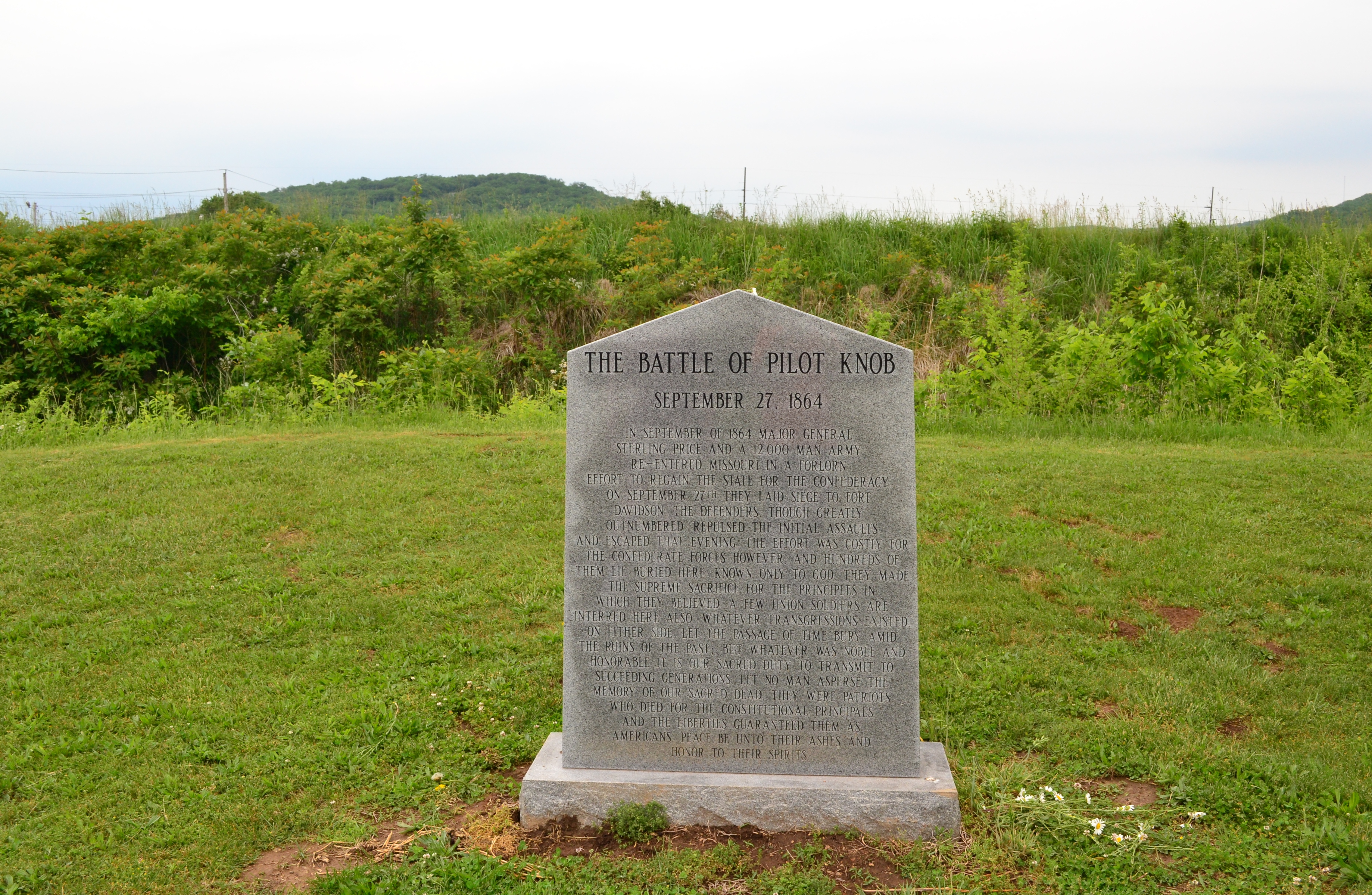
The Fort Davidson battlefield was added to the Missouri State Park system in 1968 and placed on the National Register of Historic Places on February 26, 1970. The earthen walls still trace their hexagonal outline, weathered but unmistakable. The crater from the magazine explosion gapes on the fort's eastern side, a depression that has remained through more than 160 years. A granite monument marks the mass grave where battlefield dead from both sides were interred. The inscription reads: 'Whatever transgressions existed on either side, let the passage of time bury amid the ruins of the past.' A visitors center preserves artifacts including Ewing's sword, and the American Battlefield Trust has worked to protect additional acreage around the site.
From the Air
Located at 37.6194°N, 90.6415°W near Pilot Knob, Missouri, at approximately 900 feet MSL in the Ozark foothills. The fort site lies in a valley surrounded by four prominent hills: Pilot Knob (the tallest, to the south), Shepherd Mountain (east), Rock Mountain (northwest), and Cedar Hill. The hexagonal earthwork outline and magazine crater are visible from low altitude. Nearest airports include Farmington Regional Airport (KFAM) approximately 15 nm northwest and Arcadia Valley Memorial Airport. The Iron County landscape features rugged, wooded hills typical of the St. Francois Mountains. Best viewed at 2,000-4,000 feet AGL for valley and fort detail.