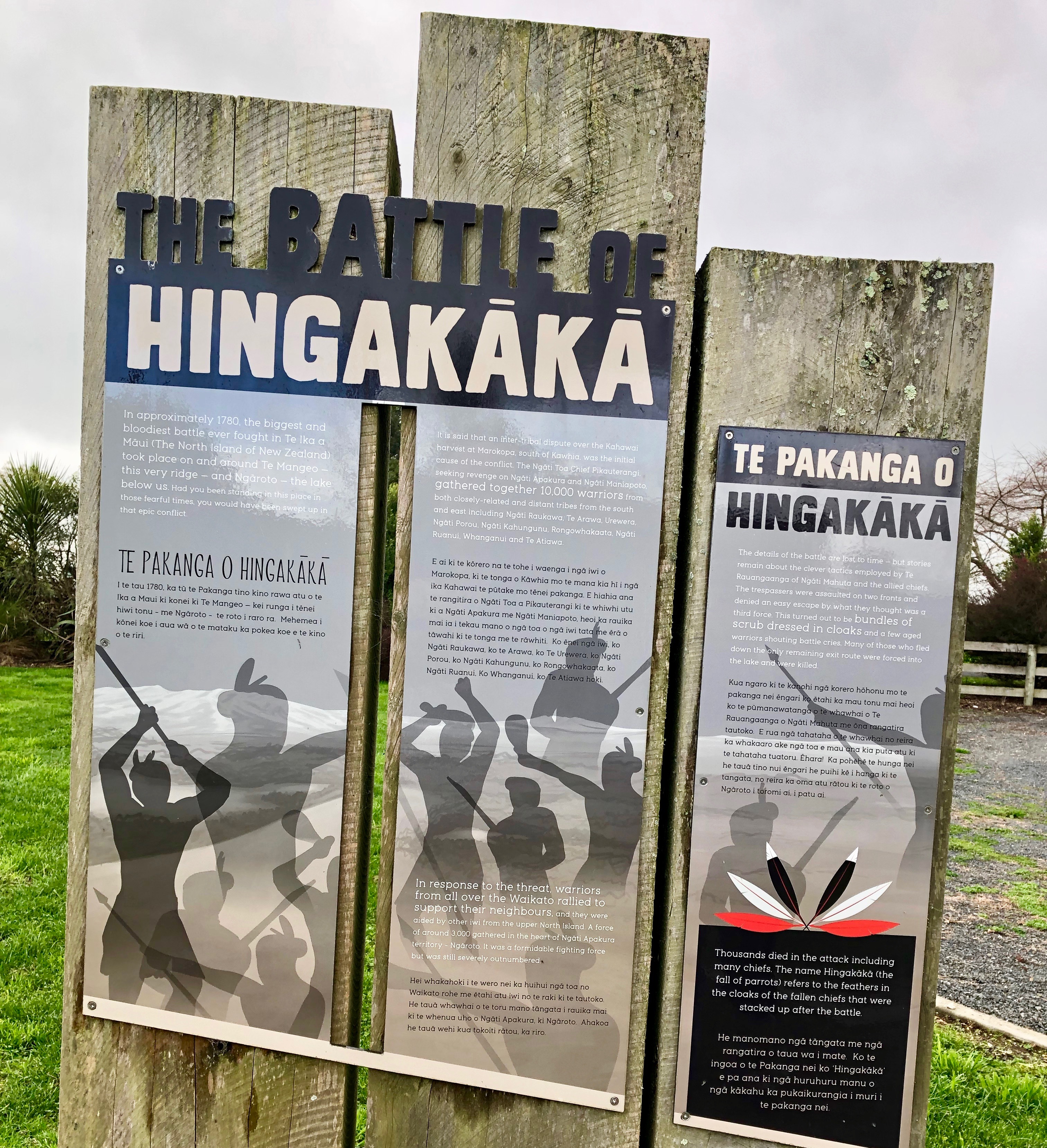
Battle of Hingakaka
It started with fish. Around 1804, at a kahawai harvest feast in the Marokopa district, a Ngati Toa chief named Pikauterangi was aggrieved over the distribution of the catch. Accounts differ on whether he seized the largest fish for himself and was humiliated for it, or whether he was simply denied his share. What happened next was not ambiguous: Pikauterangi killed members of the host clan, Ngati Apakura, and distributed their bodies for eating among allied tribes. Three years of preparation followed. By the time the armies met on the rolling country near present-day Te Awamutu, somewhere between 7,000 and 10,000 warriors had assembled on one side. It was the largest army - and the largest battle - New Zealand had ever seen.
An Alliance of Vengeance
Pikauterangi spent three years traveling the lower North Island, building a coalition of the offended and the ambitious. From the Wellington region he raised about 4,000 warriors. From the East Coast tribes of Ngati Porou and Ngati Kahungunu came another 3,000. Te Ati Awa, Ngati Ruanui, and Whanganui tribes who had previous grievances against Ngati Maniapoto joined as well. The combined force numbered between 7,000 and 10,000 - staggering for a country whose entire population at the time was perhaps 100,000.
The defenders had far fewer warriors but far better intelligence. Ngati Maniapoto and Waikato allied with Ngati Whatua from the north and Hauraki hapu, then established a chain of pa pahu - fortifications equipped with alarm devices - stretching from Kakepuku mountain to Mount Taupiri. When one pa sounded the alarm, the next picked it up, and the next after that, until every corner of the Waikato had heard. It was an early warning system built from wood, earth, and shouted voices, spanning perhaps sixty kilometers of hill country.
Feathers in the Fern
The invading army assembled at Otorohanga and marched into the Waipa district. When the two forces drew up before each other, the defenders' disadvantage was stark - roughly 1,600 warriors, or by some accounts 3,000, facing an army at least twice their size. Te Rauangaanga, the commander of the Waikato-Maniapoto alliance and father of the future paramount chief Te Wherowhero, resorted to deception. His warriors planted bunches of feathers atop fern fronds across the ridgeline, mimicking the head ornaments of warriors held in reserve. Chiefs delivered thundering speeches to these phantom battalions, creating the impression of a much larger force waiting in ambush.
The ruse bought time, and Te Rauangaanga chose his ground carefully: the Te Mangeo ridge, a narrow spur of high ground south of Lake Ngaroto. He split his army into three groups and positioned them at the ridge's end, forcing the larger army to approach along constrained terrain where their numerical advantage counted for less.
The Swoop of the Cormorant
Huahua's Ngati Maniapoto warriors struck first, charging downhill in the formation they called Te Kawau Maro - the swoop of the cormorant - a flying wedge aimed at the center of the invading force. The attackers absorbed the blow and began to envelop the wedge. This was what Te Rauangaanga had planned. His second group now rushed down the hillside and hit Pikauterangi's army in the flank while it was strung out and disorganized.
The turning point came when Te Rauangaanga himself struck down Pikauterangi. Without their leader, the invading army panicked. Warriors tried to retreat through a narrow gap between the ridge and the lake, but Tiriwa's men had been waiting in the bush along that escape route. The Ngati Toa were forced into the swamplands at the lake's margins. Some tried to swim across; patrols on the far shore killed them as they emerged. Ngati Raukawa alone are said to have lost 1,600 warriors, including two chiefs. The sacred carving Te Uenuku - a treasure of immense spiritual significance - was lost in the carnage and would not be recovered for nearly a century, until 1906.
Ripples Across Generations
The name Hingakaka itself carries the weight of what happened, though its exact meaning is debated. One tradition holds it means 'fall of kaka' - the native parrot that Maori hunted for food, invoking an image of chiefs falling like birds from the sky. Another interprets it as fish hauled up in a net called kaka. Either way, the word became shorthand for catastrophic loss.
The battle's consequences rippled across the North Island for decades. The victorious Tainui considered pursuing the defeated tribes but were warned by a tohunga's dream of a Ngapuhi attack on their northern flank - a warning that proved prescient when Ngati Whatua returned home just in time to repel an invasion at the battle of Moremonui. In the years that followed, retaliatory raids and counter-raids escalated into the broader Musket Wars of the 1820s and 1830s. The Hingakaka was not an ending but a beginning - the opening act of a generation of intertribal conflict that would reshape the demographic and political landscape of Aotearoa before European settlement compounded the upheaval.
From the Air
Located at 37.98S, 175.31E, near present-day Te Awamutu and Ohaupo in the Waikato region. The battlefield occupied the Te Mangeo ridge south of Lake Ngaroto, in gently rolling farmland that was once forested. From the air, the area appears as flat to gently undulating pastoral land between the Waipa River and the low hills to the west. Lake Ngaroto is a small lake visible southeast of the ridge. Nearest airport: Hamilton Airport (NZHN), approximately 20 km to the northeast. The Waikato River and its tributaries provide good visual navigation references. Weather is generally mild but can be overcast; visibility is usually good.