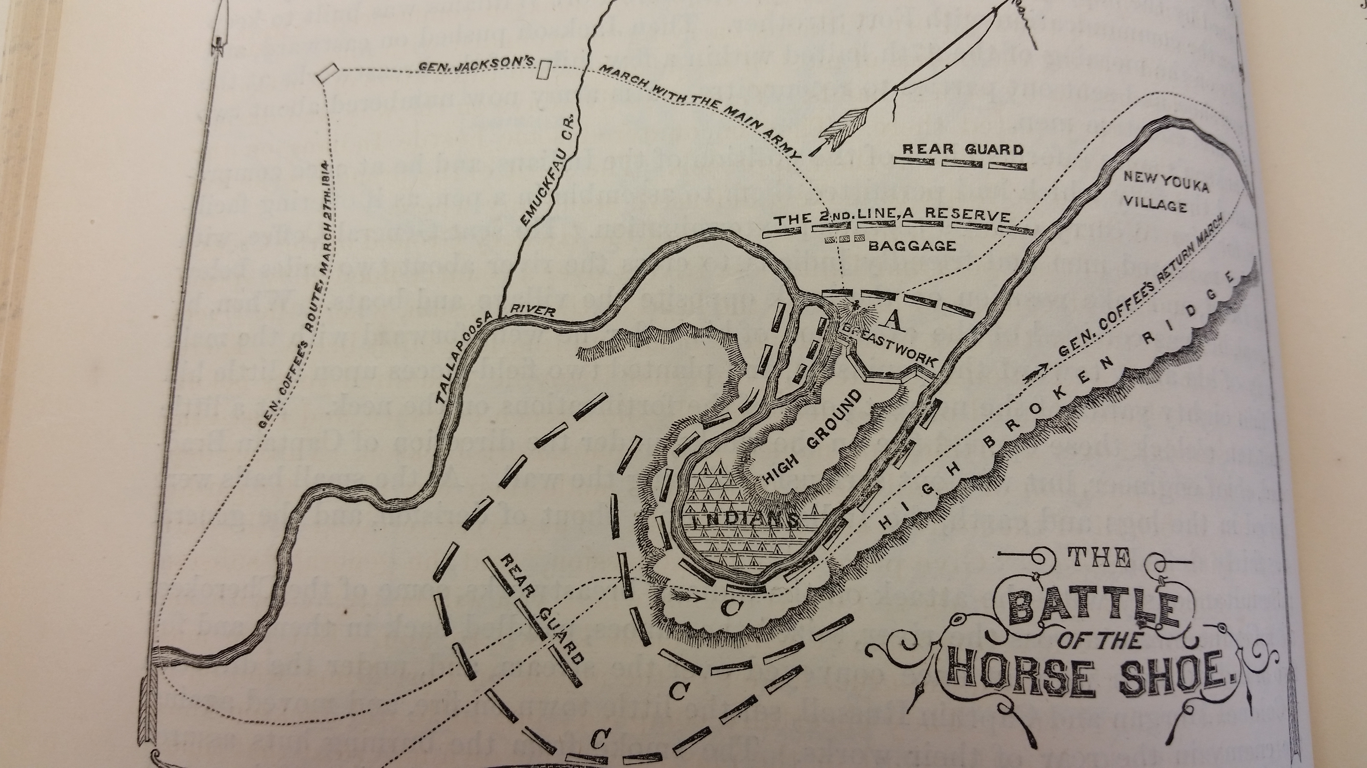
Battle of Horseshoe Bend
A young third lieutenant named Sam Houston was among the first Americans over the log barricade. A Creek arrow buried itself in his thigh -- a wound that would trouble him for the rest of his life, and one that marked the beginning of an extraordinary career that would carry him to the presidency of the Republic of Texas. But on March 27, 1814, Houston was just one of thousands of men converging on a fortified bend in Alabama's Tallapoosa River, where the Red Stick Creek had built their stronghold of Tohopeka. By nightfall, at least 800 of the 1,000 Red Stick warriors defending the peninsula lay dead, making this the single deadliest day for Native Americans in any recorded North American battle.
The Horseshoe Trap
The geography dictated the battle. The Tallapoosa River curls into a tight horseshoe shape in central Alabama, creating a hundred-acre peninsula connected to the mainland by a narrow neck of land. The Red Sticks recognized the defensive potential and built a massive log barricade across this neck -- a zigzag wall of timber with firing ports that allowed defenders to rake attackers from multiple angles. Behind the wall, 1,000 warriors and 350 women and children sheltered in the village. They believed Tohopeka was impregnable. General Andrew Jackson, commanding 3,300 troops of Tennessee militia, U.S. Infantry, and 600 Cherokee and Lower Creek allies, intended to prove them wrong.
Fire from All Sides
Jackson's plan was a classic pincer. He sent General John Coffee with 700 mounted infantry and the Cherokee allies downstream to ford the Tallapoosa and surround the far side of the bend, cutting off any escape by water. Jackson positioned his remaining 2,000 men and two small field cannons facing the barricade. At 10:30 in the morning, the artillery opened fire. For two hours the cannonballs hammered the log wall, but the green timber absorbed the impacts without breaking. The bombardment was a failure. Then, at noon, Coffee's Cherokee allies swam across the river and set fire to the village from behind. Jackson seized the moment. He ordered the 39th U.S. Infantry, led by Colonel John Williams, to charge the barricade with bayonets. The soldiers poured over the wall and into five hours of brutal hand-to-hand fighting that raged across the burning peninsula until dark.
A Nation Undone
When the shooting stopped, 557 Red Stick warriors lay dead on the field. Another 200 to 300 had been killed trying to escape across the river. Chief Menawa, severely wounded, managed to lead roughly 200 survivors through the chaos and downriver to eventual refuge among the Seminoles in Spanish Florida. Jackson's forces suffered 49 killed and 154 wounded. The Creek War was effectively over. Five months later, on August 9, 1814, Jackson forced the Creek Nation to sign the Treaty of Fort Jackson, ceding 23 million acres -- half of central Alabama and part of southern Georgia -- to the United States. The territory ceded included lands belonging to the Lower Creek, who had fought alongside the Americans as allies. The state of Alabama was carved from this domain and admitted to the Union in 1819.
Makers of History
Horseshoe Bend launched careers that would reshape the continent. Andrew Jackson's victory propelled him to major general, then national fame in the Battle of New Orleans, and ultimately the presidency. Sam Houston, despite his arrow wound, went on to become governor of Tennessee, president of the Republic of Texas, and later governor of Texas. The battle also cemented alliances and betrayals that echoed for decades -- the Cherokee who fought beside Jackson would later be driven from their homelands on the Trail of Tears by the very man they helped make powerful. Today, the battlefield sits quietly along the Tallapoosa, a 2,040-acre national military park where a 2.8-mile nature trail winds through the grounds where the barricade once stood.
From the Air
Located at 32.98N, 85.74W in east-central Alabama, along a distinctive horseshoe bend in the Tallapoosa River visible from altitude. The river's tight curve is the key landmark -- look for the peninsula shape on the south side. Nearest airport is Thomas C. Russell Field (KALX) in Alexander City, approximately 15nm northwest. Auburn University Regional Airport (KAUO) lies about 30nm southeast. The terrain is hilly with dense forest along the river corridor. Best viewed at 3,000-5,000 feet AGL for the horseshoe shape to be clearly visible.