Battle of Kohima
The most famous tennis court in military history belongs to no club. It sits on Garrison Hill in Kohima, the capital of Nagaland in northeast India, and for two weeks in April 1944, its modest rectangle marked the dividing line between the British Empire and the Japanese Imperial Army. Soldiers fought across it with grenades, bayonets, and bare hands, separated at times by little more than the width of a tennis net. The Battle of Kohima, fought from 4 April to 22 June 1944, stopped Japan's Operation U-Go -- the last and most ambitious attempt to invade India -- and turned the tide of the entire Burma campaign. In 2013, the British National Army Museum voted it, alongside the linked Battle of Imphal, as Britain's Greatest Battle. Historians have called it the Stalingrad of the East, and the comparison is not hyperbole.
A Blockhead's Gamble
The plan was audacious and possibly insane. Lieutenant General Renya Mutaguchi, commanding Japan's Fifteenth Army, had expanded a limited spoiling attack into a full-scale invasion of India. His objective was Imphal in Manipur, supplied by a single road winding through the hills from the railhead at Dimapur. Kohima sat astride that road. Capture it, and IV Corps at Imphal would starve. The 31st Division, under Lieutenant General Kotoku Sato, drew the assignment. Sato was unhappy -- he had not been consulted, had grave doubts about logistics, and privately told his staff they might all starve to death. He considered Mutaguchi a blockhead, the word he actually used. On 15 March 1944, his division crossed the Chindwin River carrying only three weeks of food and ammunition. Half their heavy weapons had been left behind.
Fifteen Hundred Against Fifteen Thousand
Kohima was supposed to be empty. British intelligence had expected the assault elsewhere, and the garrison consisted of just 1,500 troops -- Royal West Kents, Assam Regiment soldiers, and administrative personnel from a convalescent depot. Against them came roughly 15,000 Japanese soldiers converging on the ridgeline. The siege began on 4 April. Defenders were compressed into a shrinking perimeter on Garrison Hill, centered on the Deputy Commissioner's bungalow and its tennis court. Water ran short. The wounded could not be evacuated. Snipers picked off anyone who moved in daylight; at night the attacks came in waves. The fighting around the tennis court was hand-to-hand, grenades rolling downhill from one side to the other. For thirteen days, the garrison held -- barely -- until the British 2nd Division fought through Japanese roadblocks to relieve them on 18 April.
Starving the Sword
Relief did not end the battle. The Japanese had dug into the ridgeline and surrounding Naga villages, and dislodging them took two more months. The British brought overwhelming firepower -- thirty-eight mountain howitzers, forty-eight field guns, and constant air strikes from Hurricane fighter-bombers. The Japanese could answer with seventeen light guns and almost no ammunition, yet they held with extraordinary tenacity. What ultimately broke them was hunger. Shortly before the siege, they had captured a massive rice warehouse in Naga Village -- enough to feed the division for three years. RAF bombers destroyed it almost immediately. The 23rd Long Range Penetration Brigade cut supply lines behind the Japanese, and two resupply convoys were ambushed. Soldiers began dying of starvation, malaria, and dysentery in numbers dwarfing combat casualties. General Sato, receiving no supplies and no useful orders, made the extraordinary decision to withdraw without authorization -- nearly unprecedented in the Japanese Army. He openly radioed his intention, adding that Mutaguchi's headquarters had shown criminal negligence.
Milestone 109
On 22 June 1944, British and Indian troops advancing south from Kohima met forces pushing north from Imphal at Milestone 109 on the road between the two towns. The siege of Imphal was broken. Japan's invasion of India was over. The human cost was staggering. Japanese casualties in the broader U-Go offensive exceeded 50,000 dead, with thousands more succumbing to disease and starvation during the long retreat through the monsoon-soaked hills back to Burma. The roads became lined with corpses -- a route the survivors called the Road of Bones. British and Indian casualties at Kohima alone numbered over 4,000 killed and wounded. The Naga people, whose homeland became the battlefield, suffered enormously. Many had aided the British, providing intelligence and carrying wounded soldiers to safety under fire. Their villages were destroyed, their food stocks consumed or burned by both sides.
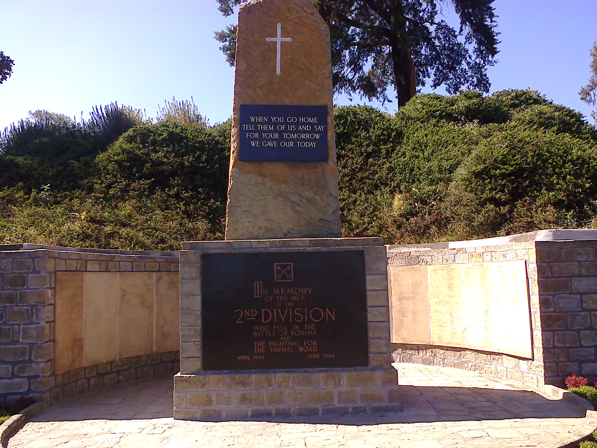
When You Go Home
Today Kohima's War Cemetery holds 1,420 Allied graves on the slopes of Garrison Hill, maintained by the Commonwealth War Graves Commission. The cemetery occupies the ground where the Deputy Commissioner's tennis court once stood -- the same patch of earth where the fighting was fiercest. Carved into the memorial of the 2nd British Division is an epitaph that has become one of the most quoted in military history: "When you go home, tell them of us and say, for your tomorrow, we gave our today." The verse is attributed to John Maxwell Edmonds and echoes the epitaph Simonides wrote for the Spartans who fell at Thermopylae in 480 BC. In 2024, the Nagaland Government unveiled a new Kohima Peace Memorial alongside Hiroshi Suzuki, the Japanese Ambassador to India. Funded by the Japan International Cooperation Agency, it stands as recognition that reconciliation, like the battle itself, is measured not in grand gestures but in the slow, patient work of remembering what was lost.
From the Air
Kohima lies at approximately 25.67N, 94.10E in the mountainous terrain of Nagaland, northeast India, at an elevation of roughly 1,444 meters (4,738 feet). The town sits on a ridge in the Naga Hills with steep terrain on all sides. The nearest significant airport is Dimapur Airport (VEMR), approximately 74 km northwest. Imphal Airport (VEIM) lies about 130 km to the south. When approaching from the air, look for the ridgeline settlement surrounded by dense green hills. The war cemetery on Garrison Hill is visible as a maintained green space amid the town's development. Visibility can be limited during monsoon season (June-September) due to cloud cover and heavy rainfall.