
Battle of La Haye-du-Puits
An allied aerial photograph of an eight-square-mile patch of the Cotentin peninsula in 1944 counted four thousand separate fields. Each one was an earth-wall enclosure between three and six feet high, topped with small trees and tangled underbrush, with one narrow gated entrance and a sunken lane along one side. Norman farmers had built them across centuries to hold livestock and protect their crops from the ocean winds. By the summer of 1944, an average linear kilometre in the Cotentin crossed fourteen of them. Soldiers of the US VIII Corps, advancing south from Cherbourg between 3 and 14 July, learned the hedgerows one field at a time, in rain that fell harder than any summer rain since 1900. The terrain was so well suited to defence that it had a name of its own: the bocage. The battle for La Haye-du-Puits would cost ten thousand American casualties to advance seven miles.
After Cherbourg
Following D-Day on 6 June, the Allied plan called for the British Second Army under Lieutenant-General Miles Dempsey to take Caen and secure the eastern flank, while the First US Army under Lieutenant General Omar Bradley pushed south and west to seize Cherbourg by D+15, drive to the Loire by D+20, clear Brittany, and then turn east to the Seine by D+90. Almost none of that happened on schedule. Caen held against the British. A June storm wrecked the American Mulberry artificial harbour, slowing the buildup. Cherbourg did not fall until 26 June, and organised German resistance in the northern Cotentin only ended on 1 July. By then the next task was already clear: advance south to firm ground from which mechanised forces could be used. The US VIII Corps, under Major General Troy H. Middleton, was ordered to push 20 miles to Coutances. Eisenhower wanted it started immediately, before the Germans could consolidate. Bradley elected to commit forces piecemeal as they arrived rather than wait for the full corps to assemble.
The Bocage
The hedgerows turned the campaign into something closer to siege warfare than maneuver. Heavy machine guns were dug into the earthen embankments at each field's corners, with light machine guns and machine pistols sweeping along American lines of advance. Snipers were a key element of the defence. Field telephones connected positions and let German observers call in mortar and artillery fire on Americans pinned in open fields - mortar shells alone caused around three-quarters of American casualties in Normandy. Field entrances were covered by machine guns and anti-tank guns. The hedgerows themselves were sown with land mines and tripwire-activated booby traps. Slit trenches were dug into the embankments. Hand-held panzerfausts handled close-range armour; 88 mm guns handled it at distance. The German LXXXIV Corps under Generalleutnant Dietrich von Choltitz - and above him SS-Obergruppenführer Paul Hausser, commanding the Seventh Army - used the terrain methodically: a light forward line, dense defensive depth behind it, and reserves held back for counter-attacks. The summer of 1944 was the wettest the area had seen since 1900. Low cloud often grounded the fighter-bombers and observation aircraft on which American firepower depended.
Eleven Days, Four Divisions
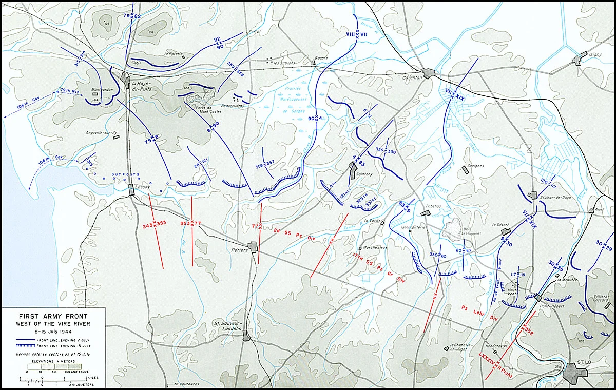
The American attack began before dawn on 3 July with a fifteen-minute artillery bombardment at 05:15. Air support was already cancelled by rain. The 82nd Airborne Division attacked first, achieving partial surprise by going in conditions the LXXXIV Corps staff had thought would force a postponement. The 82nd took Hill 131 and the key La Poterie ridge - paying for both with the close-quarter casualties that the bocage extracted as a matter of routine. The 79th Infantry Division captured Hill 121 and pressed toward Montgardon ridge. The 90th Infantry Division - which had struggled badly earlier in the campaign - fought through heavy resistance to take Mont Castre ridge and push toward Périers. The 8th Infantry Division captured the ridge overlooking the Ay River. By 14 July the Americans had reached their objective, the Sèves River. The advance was seven miles. Coutances, the original target, was still fourteen miles away. The Germans had withdrawn in good order rather than break.
What the Casualties Bought
The VIII Corps suffered over 10,000 casualties in eleven days. About 90 percent of them were infantrymen; officer losses were particularly heavy. Most wounds were caused by shell fragments. Many of the casualties were soldiers who, in the words of post-battle assessments, failed to remember what they had been taught in basic training - inexperience compounding the terrain. Combat fatigue cases, often uncounted, were treated in two First Army centres and usually returned to their units within 24 to 72 hours. The Germans suffered too, though the scattered way their divisions had been committed makes precise numbers difficult. The 243rd Infantry Division alone reported 8,000 casualties in Normandy. By 11 July, all of Army Group B had received only 5,210 replacements - about 12 percent of its losses. Field Marshal Günther von Kluge reported to OKW that the defence in Normandy might not hold because he could not afford the casualties. Eisenhower ranked the campaign's hardest factors as the quality of the German soldier, the rugged terrain, and the weather - in that order. The grinding battle for the Cotentin hedgerows had not won the breakthrough, but it had set up the one that followed: Operation Cobra, launched on 25 July, broke through where La Haye-du-Puits had worn the defenders thin. By 31 July, the First Army was finally clear of the bocage. Three weeks later, on 24 August, the left bank of the Seine had been cleared. Operation Overlord, expected to take 70 days, had been completed in 79 - close enough to plan that the variance fell within the original margin. Of the soldiers who made that possible, ten thousand from VIII Corps alone never marched out of the hedgerows.
From the Air
La Haye-du-Puits is a small commune in the western Cotentin peninsula of Normandy, at approximately 49.273°N, 1.569°W. From the air the landscape is still recognisably bocage country - a patchwork of small irregular fields edged by mature hedgerows, with sunken lanes running between them. Hill 131 and La Poterie ridge are visible to the north-east. The Ay and Sèves rivers run roughly east-west south of the town. Nearby airports: Lessay (LFOM) 9 nm south, Cherbourg-Maupertus (LFRC) 29 nm north, Granville (LFRF) 25 nm south. Best viewing altitude 2,000-4,000 ft for the full landscape; descend to 1,000-1,500 ft to see the individual hedgerows. The American military cemeteries at Saint-James and Colleville are within reach of any tour of the campaign.
Nearby Stories
- Action at Cherbourg (1692) 7.2 km away
- Grosnez Castle 11 km away
- Alderney Society Museum 17 km away
- Mont Saint-Michel: The Abbey That Becomes an Island Twice a Day 46 km away
- D-Day: The Longest Day 57 km away
- Fishbourne Roman Palace 142 km away
- Battle of Verneuil 149 km away
- 1941 Santander Fire 634 km away