Battle of Little Blue River
Confederate cannoneers fired blank cartridges, hoping the noise alone would fool the Union cavalry into retreating. It was that kind of fight -- improvised, desperate, fought across shallow fords and burning bridges by exhausted men on both sides. On October 21, 1864, the Battle of Little Blue River unfolded along a small waterway east of Independence, Missouri, as part of Sterling Price's audacious cavalry raid through the state. The engagement pitted roughly 2,800 Union troops against 5,500 Confederates in a day-long struggle that previewed the decisive Battle of Westport two days later. It was a Confederate tactical victory, but the delay it imposed helped seal Price's ultimate defeat.
Price's Desperate Gamble
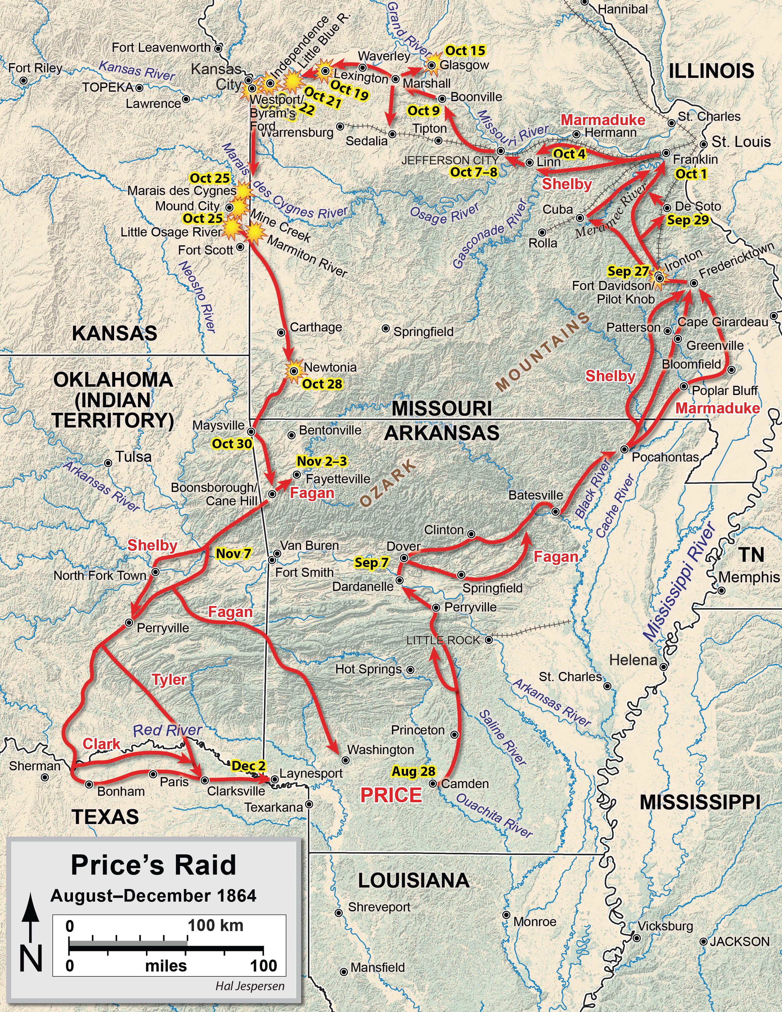
By the autumn of 1864, the Confederacy was running out of options. Major General Sterling Price proposed an invasion of Missouri designed to trigger a popular uprising, divert Union troops from critical theaters, and influence Abraham Lincoln's reelection prospects. On September 19, Price's Army of Missouri -- roughly 13,000 cavalrymen with 14 light cannons -- crossed into the state. The campaign went wrong almost immediately. A costly repulse at the Battle of Pilot Knob on September 27 forced Price to abandon his plan to capture St. Louis. Jefferson City proved too well-defended. The Confederates drifted westward along the Missouri River, gathering recruits and supplies, while Union forces closed in from multiple directions. Major General Samuel R. Curtis assembled the Army of the Border near Kansas City, combining regular troops with Kansas State Militia. Major General Alfred Pleasonton formed a cavalry division and pursued Price from the east. The noose was tightening.
Moonlight's Stand at the River
After being pushed out of Lexington on October 19, Union Major General James G. Blunt fell back toward Independence. He wanted to make a stand at the Little Blue River, but the Kansas State Militia was politically restricted from crossing the Big Blue River, leaving him short of reinforcements. Curtis ordered Blunt to leave a holding force and fall back. Colonel Thomas Moonlight was given the thankless assignment: defend the river crossing with just the 11th Kansas Cavalry Regiment and four cannons -- between 400 and 600 men. Moonlight placed companies at a bridge and at fords north and south, but the defenders did not know the terrain. Missouri-born Confederates did. When Brigadier General John B. Clark Jr.'s brigade attacked at 7:00 AM on October 21, the 5th Missouri Cavalry's lead company lost over a third of its strength in the initial clash, but the Confederates found unguarded fords and began crossing in force. The bridge defenders set it ablaze and fell back to a hilltop marked by a stone wall.
Blank Cartridges and Repeating Rifles
From their hilltop position, the 11th Kansas Cavalry repulsed the 10th Missouri Cavalry's uphill assault with devastating fire from their repeating rifles. Confederate Colonel Colton Greene managed to get his 3rd Missouri Cavalry across the ford -- all 150 men of it -- supported by three cannons from Harris's Missouri Battery. The entire 11th Kansas counterattacked. When the fighting closed to hand-to-hand range, the Confederate artillerists could no longer fire without hitting their own men. So they fired blank cartridges, hoping the sound would convince the Kansans they were under heavy bombardment. Greene believed the ruse worked. The two sides traded counterattacks with neither gaining a decisive advantage, locked in a grim stalemate along the river's wooded banks.
Blunt Returns to the Fight
Around 11:00 AM, Blunt received permission from Curtis to bring his troops back to the Little Blue. He returned with reinforcements including Colonel James H. Ford's command -- the 2nd Colorado Cavalry, part of the 16th Kansas Cavalry, and McLain's Colorado Battery. Union strength grew to about 2,800 men with 15 cannons, facing approximately 5,500 Confederates from Marmaduke's and Shelby's divisions. Though outnumbered nearly two to one, the Union troops held superior firepower. Shelby fed Thompson's and Jackman's brigades into the fight and pressed the Union center. Nichols's Missouri Cavalry, still mounted, threatened the Union left flank. When Curtis sent McLain's Battery to counter the flank threat, it weakened the center. With ammunition running low and pressure mounting from multiple directions, the Union troops began a fighting withdrawal. Ford and Moonlight organized a disciplined rear guard, leapfrogging ranks in alternating retreat. McLain's Battery was caught exposed and rescued by the 11th Kansas; those Kansans were then rescued by a charge from the 2nd Colorado. By 4:00 PM, the fighting was largely over.
The Road to Westport
Casualties were significant but difficult to tally precisely. The 11th and 15th Kansas Cavalries and 2nd Colorado Cavalry together lost 20 killed. The Confederate 3rd Missouri Cavalry suffered 31 killed and wounded. Among the dead was Confederate guerrilla leader George Todd, shot through the throat in the final stages of the fighting. Historian Mark Lause estimates the Union may have lost up to 300 men, with Confederate losses possibly higher. The battle delayed Price's advance and set the stage for the decisive engagements that followed. The next day, Pleasonton retook Independence in the Second Battle of Independence. On October 23, Curtis and Pleasonton defeated Price at the Battle of Westport -- sometimes called the 'Gettysburg of the West' -- forcing the Confederates into a retreat through Kansas that eventually took them all the way to Texas. Price had entered Missouri with 12,000 to 13,000 men. He returned with about 3,500. Today, the battlefield is fragmented by highway development, though a driving tour with interpretive markers covers the sites of both the Little Blue and Second Independence battlefields.
From the Air
Located at 39.137°N, 94.314°W east of Independence, Missouri. The Little Blue River runs roughly north-south through the eastern suburbs of the Kansas City metropolitan area. The battlefield is now largely developed, but the river corridor and surrounding terrain are visible from altitude. Kansas City International (KMCI) is approximately 30 miles northwest. Lee's Summit Municipal Airport (KLXT) is roughly 10 miles south. Charles B. Wheeler Downtown Airport (KMKC) is about 15 miles west. The Little Blue River crossing and surrounding area can be observed from 3,000-5,000 feet, with the river's wooded corridor contrasting against suburban development.