Battle of Madagascar: When Allies Fought Allies in the Indian Ocean
The French defenders held Madagascar longer against the British in 1942 than France itself had held against Germany in 1940. That fact captures something essential about this strange campaign: it was not a fight between enemies but between former allies divided by the fall of France. When Vichy authorities controlled Madagascar, and Japanese submarines prowled the Indian Ocean hunting Allied shipping, Churchill concluded that the island's strategic harbors could not be left in hands that might - willingly or under pressure - open them to the Axis. What followed, from May 5 to November 6, 1942, was a six-month operation involving British, South African, East African, and Rhodesian forces against French colonial troops and their Malagasy conscripts - soldiers who had no quarrel with each other and, in many cases, no clear understanding of why they were fighting.
The Strategic Gamble
Diego Suarez Bay, near Madagascar's northern tip, was the prize. Its fine natural harbor and narrow entrance through Oronjia Pass made it one of the best-protected anchorages in the Indian Ocean. By early 1942, Japanese submarines roamed freely from the Bay of Bengal to the coast of East Africa, their Kaidai-class boats possessing the longest range of any Axis submarines. In December 1941, German Vice Admiral Fricke had met Japan's naval attache in Berlin to carve up operational zones; by March 1942, Fricke was pressing the Japanese to prioritize Madagascar and Ceylon over Australia. Churchill recognized the threat. If Japan established forward submarine bases on Madagascar, Allied supply lines to India, Australia, and the Middle East would be severed across half the globe. But the memory of the humiliating failure at Dakar in 1940, where a joint British-Free French operation had been repulsed by Vichy defenders, made Churchill insist on one condition: De Gaulle's Free French would be excluded entirely.
Operation Ironclad
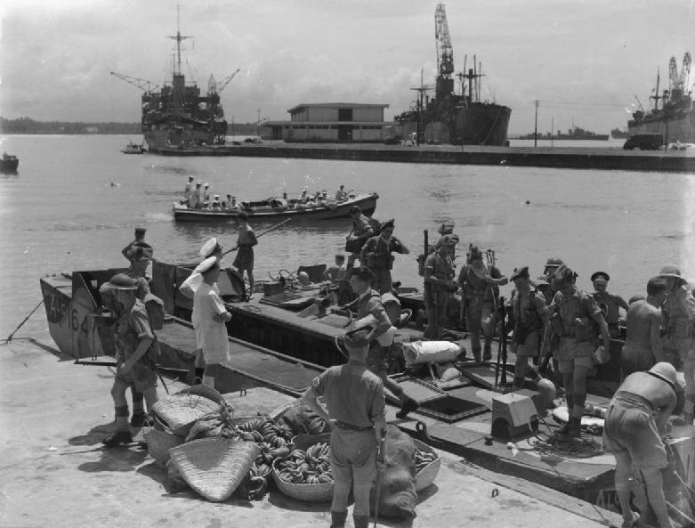
Force 121 sailed from Scotland on March 23, assembled at Durban, and struck on May 5. It was the first British amphibious assault since the catastrophe at Gallipoli twenty-seven years earlier, and the planners were determined it would not fail. Over fifty warships covered the landings at Courrier Bay and Ambararata Bay, west of Diego Suarez. Fairey Swordfish torpedo bombers sank the armed merchant cruiser Bougainville and a submarine at anchor. On the ground, the British expected a quick surrender. They did not get one. The Vichy defenses, known as the Joffre Line, were elaborately fortified with trenches, redoubts, and pillboxes flanked by impenetrable swamps. By the end of the second day, ten of the twelve British tanks had been destroyed. Admiral Darlan cabled Governor Annet from Vichy France: "Fight to the limit of your possibilities... and make the British pay dearly." What broke the deadlock was audacity. An old destroyer dashed straight past the harbor defenses and landed fifty Royal Marines in the Vichy rear, creating what one report called "a disturbance out of all proportion to their numbers."
The Long Chase South
Capturing Diego Suarez did not end the campaign. Field Marshal Jan Smuts of South Africa had warned that holding only the northern port would leave the rest of the island open to Japanese exploitation, and events proved him right. In September, the Allies launched three simultaneous operations - Stream, Line, and Jane - to seize the western port of Majunga, the eastern port of Tamatave, and the capital Tananarive. No. 5 Commando stormed the Majunga quayside under machine gun fire, captured the post office and governor's residence, and raised the Union Jack. The advance inland toward the capital was slowed by obstacles the Vichy forces erected across every road. When they tried to destroy a critical bridge, they only managed to sag its central span into the river - Allied vehicles could still cross. A Vichy aircraft sent to finish the job with bombs missed the target. Tananarive fell on September 23 with little resistance, but Governor Annet escaped south. The King's African Rifles, East African infantry, and South African armoured cars pursued him for weeks through the island's interior.
The Conscripts' War
Behind the strategic calculations and regimental histories were the people who actually bore the fighting. The 8,000 Vichy troops defending Diego Suarez were mostly conscripted Malagasy soldiers - men from the island itself, fighting under French officers for a government most had never seen, against British forces they had no reason to oppose. On the Allied side, the campaign drew heavily on African soldiers: the King's African Rifles, East African brigades, Northern Rhodesian regiments, and South African units did much of the fighting after the initial landings. The Allies suffered about 500 casualties taking Diego Suarez and another 120 in the subsequent operations. The Vichy losses were heavier; at Andramanalina, the last major action on October 18, 800 Vichy troops surrendered after the King's African Rifles outmaneuvered them in a U-shaped valley. Annet, finally unable to flee further, asked for terms. The armistice was signed at Ambalavao on November 6, 1942.
Aftermath and Independence
With Madagascar secured, the Allies established military and naval installations across the island. Its deep-water ports controlled the sea passage to India and the Persian corridor, now beyond Axis reach. Historian John Grehan has argued that preventing Japan from gaining a foothold on Madagascar was so pivotal that it contributed to Japan's eventual defeat. Free French General Paul Legentilhomme was appointed High Commissioner in December 1942, replacing British administration. But the island's people had drawn their own conclusions from watching European powers fight each other on Malagasy soil. In 1947, Madagascar erupted in the Malagasy Uprising, a costly bid for independence that was violently suppressed. It took twelve more years. On June 26, 1960, the Malagasy Republic proclaimed its independence from France - a nation that had been fought over by its colonial rulers but never consulted about its own future.
From the Air
The battle centered on Diego Suarez Bay (now Antsiranana Bay) at 12.27S, 49.28E, near the northern tip of Madagascar. The bay is one of the largest natural harbors in the Indian Ocean, clearly visible from altitude with its narrow Oronjia Pass entrance. Nearest airport: Arrachart Airport (FMNA) at Diego Suarez. The landing beaches at Courrier Bay and Ambararata Bay are west of the harbor entrance. The campaign extended south through Majunga (now Mahajanga, FMNM), Tamatave (now Toamasina, FMMT), and the capital Tananarive (now Antananarivo, FMMI). Best viewed from 5,000-8,000 feet to appreciate the bay's defensive geography.