Battle of Marais des Cygnes
By the time Sterling Price's Confederate column reached the Marais des Cygnes River on the night of October 24, 1864, the grand invasion of Missouri was already collapsing. Price had entered the state five weeks earlier with 13,000 cavalrymen and dreams of recapturing Missouri for the Confederacy. He had been bloodied at Pilot Knob, turned away from St. Louis, bypassed Jefferson City, and defeated two days earlier at the Battle of Westport near Kansas City. Now his battered army was retreating into Kansas with Union cavalry in pursuit. What unfolded the next morning along the banks of this French-named river -- the "Marsh of the Swans" -- was the beginning of the end for the last major Confederate offensive west of the Mississippi.
Price's Desperate Gamble
The Confederacy was dying in the fall of 1864. General Edmund Kirby Smith, commanding the Trans-Mississippi Department, could not move his infantry east because the Union Navy controlled the Mississippi. Instead, he approved Price's plan to invade Missouri -- hoping it would spark a popular uprising, divert Union forces, and boost General McClellan's chances against Lincoln in the November election. Price's Army of Missouri, organized into three divisions under Marmaduke, Shelby, and Fagan, carried only 14 small-bore cannons, and thousands of his men were unarmed or poorly armed. The campaign began with promise at the Battle of Glasgow and the capture of Sedalia, but the Confederate defeat at Westport on October 23 turned the invasion into a retreat. Price burned south toward Kansas with his remaining troops and a slow-moving wagon train.
Dawn on the River
Union Brigadier General John B. Sanborn had been skirmishing with Price's rearguard through the night. By morning, his force had been reinforced by cavalry under Lieutenant Colonel Frederick W. Benteen -- the same officer who would later ride with Custer at Little Bighorn -- bringing Union strength to 3,500 men. At first light, Sanborn struck Major General Marmaduke's rearguard north of the river. The Union attack drove the Confederates from their position, capturing cannons, prisoners, and wagons. Marmaduke attempted to hold the river crossing, but a Union cavalry regiment found an unguarded ford and outflanked him. Brigadier General John B. Clark Jr.'s brigade of 1,200 men fought a desperate rearguard action to buy Price time, but it was not enough.
Three Battles in One Day
The fighting at Marais des Cygnes was only the first act. Later that morning, some of Price's men were caught at nearby Mine Creek and suffered a catastrophic defeat -- one of the largest cavalry engagements of the war, where Marmaduke himself was captured. That evening, a third engagement at the Marmiton River completed the day's destruction. After Marmiton, Price burned his entire supply train so it would no longer slow his retreat. The three battles of October 25 shattered what remained of Confederate offensive capability in the Trans-Mississippi. A final defeat at the Second Battle of Newtonia on October 28 ended any remaining hope. Price's column retreated through Arkansas and Indian Territory to Texas, arriving in December. Only 3,500 of the 12,000 men he had brought into Missouri remained.
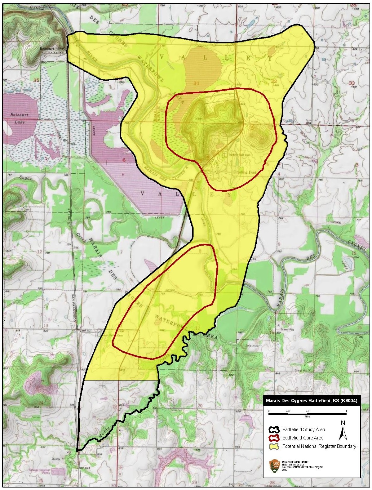
A River in Linn County
The Marais des Cygnes River still flows through Linn County, Kansas, its French name a reminder of the fur traders who preceded both armies. The battlefield lies in the gently rolling prairie of eastern Kansas, where timber-lined waterways cut through open grassland. The engagement here was part of a larger pattern -- Missouri and Kansas had been tearing each other apart since the Bleeding Kansas era of the 1850s, and the border region saw some of the Civil War's most vicious fighting. Price's Raid was the last great convulsion. The battlefield has been identified by the American Battlefield Protection Program as likely eligible for the National Register of Historic Places. The terrain that shaped the fighting -- river crossings, open ground, and the rolling hills where Marmaduke tried to make his stand -- remains largely unchanged.
From the Air
Located at 38.255N, 94.678W in Linn County, eastern Kansas, along the Marais des Cygnes River. Elevation approximately 850 feet MSL. The river is visible as a tree-lined waterway through open prairie farmland. The nearby Mine Creek Battlefield State Historic Site is visible several miles to the south. Pleasanton Municipal Airport (K44) lies approximately 8 miles southwest. The terrain is gently rolling with scattered timber along drainages. Best viewed at 2,000-4,000 feet AGL, with the river crossings clearly visible.