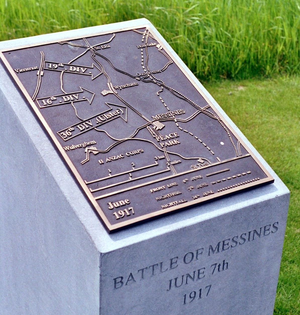
Battle of Messines (1917)
Routine British artillery fire stopped around 3:00 AM on June 7, 1917. For a few minutes, birdsong could be heard over the Flanders trenches. Then, at 3:10 AM, nineteen mines containing nearly one million pounds of explosives detonated beneath the German lines on Messines Ridge. The blast was heard in London, 140 miles away. The explosion killed an estimated 10,000 German soldiers instantly, obliterated key defensive positions, and launched the most meticulously planned British attack of the First World War. The Battle of Messines would demonstrate what methodical preparation, innovative engineering, and overwhelming firepower could achieve, a counterpoint to the slaughter that had defined the Western Front.
Two Years Underground
British sappers had begun tunneling toward the German positions in early 1916. Working in a layer of blue clay 80 to 100 feet underground, they drifted galleries toward points beneath the German front-line positions despite constant German counter-mining efforts. Twenty-two mines were planned; nineteen were ready by June 1917. Military geologist Edgeworth David planned the system, navigating complex sub-surface conditions and separate groundwater tables that made mining extraordinarily difficult. The tunnels extended beneath strongpoints across the ridge from Ploegsteert Wood in the south, through Messines and Wytschaete to Mount Sorrel. The Germans knew the British were mining and conducted their own counter-mining operations, but they could not locate all the chambers. Beneath their feet, nearly a million pounds of ammonal waited.
The Ridge That Watched
Messines Ridge had dominated British positions since 1914. From Wytschaete, 260 feet above the plain and only three miles from Ypres, German observers could watch every movement in the British rear areas. The ridge gave commanding views of the defenses around Ypres, from where the British planned their advance toward Passchendaele and eventually the Belgian coast. General Sir Herbert Plumer's Second Army was tasked with eliminating this observation advantage before the larger offensive could begin. The tactical objective was simple: capture the German defenses running from Ploegsteert Wood through Messines and Wytschaete to Mount Sorrel. The method would be anything but.
Science and Slaughter
The Second Army centralised its artillery and devised a plan of unprecedented sophistication. Field survey, gun calibration, weather data, and new highly accurate maps improved artillery accuracy dramatically. Systematic target-finding used new sound-ranging equipment and better flash-spotting organisation. Counter-battery bombardments increased from twelve in the week ending April 19 to 122 in the last ten days before the attack. A survey of captured ground found that 90 percent of German artillery positions had been plotted. Aircraft and eight observation balloons positioned behind British lines provided eyes over the reverse slopes. When the mines detonated, 2,266 guns opened fire simultaneously, the largest artillery concentration of the war to that point.
The Morning of Fire
The nine attacking divisions advanced as German artillery response came scattered and late, falling on assembly trenches already vacated. The II Anzac Corps, with the 3rd Australian Division, New Zealand Division, and 25th Division, attacked the southern part of the ridge. The 3rd Australian Division had been disorganised by a German gas bombardment on Ploegsteert Wood around midnight but pressed on. The New Zealand Division captured Messines by 5:00 AM. IX Corps in the center, including the 36th Ulster, 16th Irish, and 19th Western divisions, advanced on a front that tapered from 3,700 yards to 2,500 yards at the summit. By 7:00 AM, British troops stood on the Messines-Wytschaete ridge that had overlooked them for nearly three years.
A Different Kind of Victory
The Battle of Messines achieved its objectives with relative precision. By June 14, the British had advanced to the Oosttaverne line and consolidated their gains. German counterattacks failed to recover the lost ground. The attack forced the Germans to move reserves to Flanders from the Arras and Aisne fronts, relieving pressure on the French army, still recovering from the failed Nivelle Offensive and widespread mutinies. The cost was high but controlled compared to the Somme. Messines proved that methodical preparation could succeed where improvisation and optimism had failed. Yet the lessons would be imperfectly applied in the larger Passchendaele campaign that followed, where mud and German defenses combined to create another catastrophe. Three of the original mines were never detonated; one exploded during a thunderstorm in 1955, and two remain buried beneath the Belgian fields.
From the Air
Located at 50.76°N, 2.90°E near the village of Messines (Mesen) in West Flanders, Belgium. The ridge between Messines and Wytschaete is visible from the air, as are several preserved mine craters now filled with water, including the Pool of Peace at Spanbroekmolen. Nearest airports: Lille-Lesquin (LFQQ) 25nm south, Kortrijk-Wevelgem (EBKT) 15nm northeast. Best viewed at 3,000-4,000 feet AGL. The Irish Peace Park at Messines and numerous Commonwealth War Graves Commission cemeteries dot the landscape. Ypres and the Menin Gate are 6nm north.