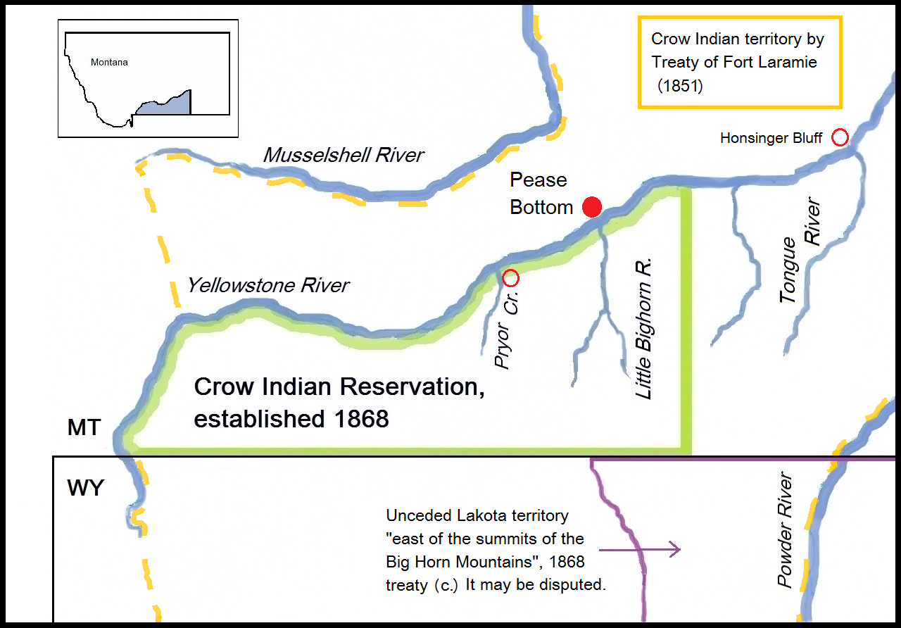
Battle of Pease Bottom
In the pre-dawn hours of August 11, 1873, gunfire crackled across the Yellowstone River. Warriors from Sitting Bull's village were shooting into Custer's cavalry camp. Three years before their fateful meeting at Little Bighorn, George Armstrong Custer and the Hunkpapa medicine man faced each other for the first time. Many of the same warriors who fought that morning along the Yellowstone would fight again in 1876. This time, at Pease Bottom, Custer would survive.
The Railroad Survey War
Custer's cavalry was escorting the Northern Pacific Railway survey party along the Yellowstone River in the summer of 1873. Colonel David S. Stanley commanded the entire expedition: 1,300 soldiers, two artillery pieces, 275 mule-drawn wagons, and 353 civilian surveyors. Twenty-seven Indian and mixed-blood scouts provided reconnaissance. The railroad meant everything to the nation's expansion and nothing good to the Lakota, Cheyenne, and other tribes who depended on the buffalo herds that the iron horse would inevitably scatter. Just a week earlier, on August 4, Lakota warriors had attacked the column at Honsinger Bluff, killing two officers and a veterinarian.
Treaty Lands and Broken Promises
The ground where Custer camped had a complicated history. The Treaty of Fort Laramie in 1851 had designated this area as Crow Indian country, a fact the Lakota themselves acknowledged. But by 1868, the Crow had agreed to a smaller reservation, and the land north of the Yellowstone, including Pease Bottom, became U.S. territory. The Lakota who attacked Custer that morning were themselves on land they had taken from other tribes. The conflict between the United States and the buffalo-seeking Lakota was, in essence, a collision between two expanding empires.
Dawn Attack
Sitting Bull's village numbered between 400 and 500 lodges, fielding an estimated 800 to 1,000 warriors. Among their leaders were Gall and the war chief Rain in the Face of the Hunkpapa, Crazy Horse of the Oglala, and warriors of the Miniconjou and Cheyenne. As dawn broke, warriors crossed the Yellowstone above and below Custer's position and attacked from multiple directions. Private John Tuttle of Company E fell in the morning fighting after killing at least three warriors across the river. The 7th Cavalry defended their camp, then counterattacked with a charge that drove the warriors eight miles from the battlefield.
Casualties and Consequences
The battle cost the army one killed and four wounded, plus at least one horse. Second Lieutenant Charles Braden suffered a shattered thigh that would keep him on sick leave until his retirement in 1878; he was posthumously awarded the Distinguished Service Cross in 1925. Custer estimated Lakota losses at forty warriors. Colonel Stanley's column appeared during the engagement and hurried to support, though the battle was already turning. For the Lakota, this was a setback but not a defeat. For Custer, it was a victory that may have bred overconfidence. Three summers later, along the Little Bighorn just south of here, that confidence would prove fatal.
From the Air
Located at 46.17N, 107.47W near present-day Custer, Montana, the battlefield sits where the Bighorn River meets the Yellowstone. The terrain is classic Montana river bottom surrounded by bluffs and rolling prairie. From altitude, the confluence of the two rivers provides clear geographic reference. The Little Bighorn Battlefield lies approximately 30 miles to the south-southwest. Nearest airports: Miles City (KMLS) approximately 50 miles east, or Billings Logan International (KBIL) approximately 70 miles west. Best viewed at 3,000-5,000 feet AGL to appreciate the tactical significance of the river crossing and surrounding terrain.