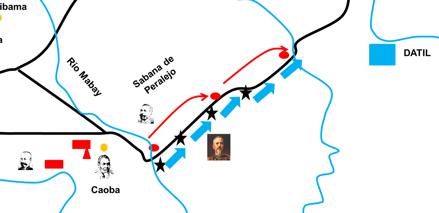
Battle of Peralejo
The ambush was supposed to be clean. Major General Antonio Maceo had chosen the ground carefully - El Santisimo, a position commanding both routes from Barrancas to Bayamo - and spread his forces across an arc of road, jungle, and savanna. Infantry under Brigadier Jesus Rabi and Colonel Quintin Banderas held the lower route near Solis. Cavalry waited in reserve. On the morning of July 13, 1895, some 1,500 Spanish troops marching to resupply the garrison at Bayamo were expected to walk straight into the trap. Instead, Captain General Arsenio Martinez Campos - Spain's senior military commander in Cuba - learned of the Cuban positions from local informants and changed his route. The ambush failed before a shot was fired. What followed was something more chaotic and more costly: a running battle through the countryside southwest of Bayamo that would kill senior officers on both sides and demonstrate that Cuba's independence war would be no quick affair.
The Trap That Never Closed
Maceo had been building toward this moment for weeks. During the First Eastern Campaign of the Cuban War of Independence, he marched forces from Cambute and Santiago de Cuba toward Bayamo, the administrative head of the eastern district. On July 5, Brigadier Rabi joined him with reinforcements from Jiguani, and by July 7, the combined rebel force had camped along the Buey River near Valenzuela. Intelligence relayed by Rafael Silveira revealed that Spanish convoys were massing at Veguitas for a supply run to Bayamo. Maceo saw his opportunity. Major General Bartolome Maso, head of the 2nd Liberation Army Corps, arrived with additional cavalry, and by midnight on July 12, the liberating army was in motion. The plan was sound. But Martinez Campos had his own informants, and the Spanish general had not survived decades of colonial warfare by walking into obvious traps.
Fire at La Caoba
When the Spanish evaded the primary ambush, they did not simply pass by - they turned the tables. Martinez Campos split his 1,540-man column at Barrancas, sending Brigadier Fidel Alonso de Santocildes through the mountains on a parallel path while he himself advanced along the Peralejo road with Captain Travesi's guerrillas. The maneuver outflanked Rabi's infantry and struck directly at the Cuban rearguard. Around ten in the morning, after Cuban fighters had waited nearly six hours in position, the battle erupted at La Caoba. Santocildes's troops slammed into the supply train guarded by Brigadier Alfonso Goulet. The fighting was immediate and brutal. Goulet died in the confrontation, the first senior Cuban officer to fall that day. Commander Moncada fell shortly after as Maceo rode forward with his staff to assess the enemy's positions and ordered his cavalry to counterattack. The neat ambush had become a brawl.
Cavalry Across the Savanna
What saved the Cuban position from collapse was Maceo's ability to adapt under fire. He ordered infantry to flank right and interpose themselves between the Spanish and La Caoba, while cavalry held the line. The two Spanish columns merged and pushed toward the Peralejo savanna, open ground where horsemen could maneuver freely. Cuban infantry claimed the flanking mountains while cavalrymen from the Luz de Yara and Cespedes regiments fanned across the savanna on the enemy's left. At this critical moment, reinforcements arrived: three squadrons of the Gua regiment under Colonel Salvador Hernandez Rios, 250 fresh riders who crossed the Babatuaba River to join the fight. In the confusion, Cuban guerrillas mistakenly fired on their own reinforcements before the mix-up was sorted.
A Bloody Draw
Under the combined Cuban assault, the Spanish fought their way to the Mabay River. Maceo and his staff personally occupied the river crossing alongside the Gua regiment, pouring fire into the retreating column. When the Cuban infantry ran out of ammunition, Maceo shifted them aside and sent the Cespedes regiment cavalry to press the pursuit. The Spanish were harassed hard as far as El Datile and pursued weakly all the way to Bayamo, where Campos and the remnants of his column finally found safety. The cost was severe on both sides. Spain lost 28 dead - including Brigadier Santocildes, one of their most capable field commanders - and some 98 wounded. The Cuban rebels counted 118 casualties among dead and wounded, including Brigadier Goulet, Colonel Carlos Suarez, and Lieutenant Colonel Manuel la O Jay. Neither side could claim outright victory. But Maceo established his headquarters at Santa Gertrudis near Bayamo, effectively besieging the city before continuing the First Eastern Campaign toward Santiago de Cuba.
What Peralejo Proved
The battle demonstrated something both sides would spend the next three years reckoning with. Spain could not move freely through its own colony. A supply convoy escorted by 1,500 troops and commanded by the captain general himself had been intercepted, mauled, and chased to its destination by rebel forces that were outnumbered and outgunned. Martinez Campos survived, but the lesson was clear: Cuba's eastern countryside belonged to the insurgency. Maceo's ability to coordinate infantry, cavalry, and reinforcements across miles of terrain - improvising when his initial ambush failed - showed the maturity of the Cuban Liberation Army as a fighting force. The dead officers on both sides underscored that this was no low-stakes guerrilla nuisance. Senior commanders were leading from the front and dying for it. The war would grind on until 1898, when American intervention finally ended Spanish rule. But the savanna and jungle around Peralejo had already delivered the verdict.
From the Air
Located at 20.27°N, 76.76°W in eastern Cuba, southwest of Bayamo. The battlefield stretches across savanna and low mountain terrain between the Buey and Mabay rivers. Nearest major airport is Sierra Maestra Airport (MUBM) near Manzanillo, approximately 50 km to the southwest. Antonio Maceo Airport (MUCU) at Santiago de Cuba lies about 120 km to the east. From altitude, look for the green savannas flanked by low hills between Bayamo and Manzanillo - the road connecting these cities roughly traces the Spanish column's route. The terrain is a mix of open grassland and forested hills, characteristic of the Granma Province landscape. Best viewed at 3,000-5,000 feet for terrain detail.