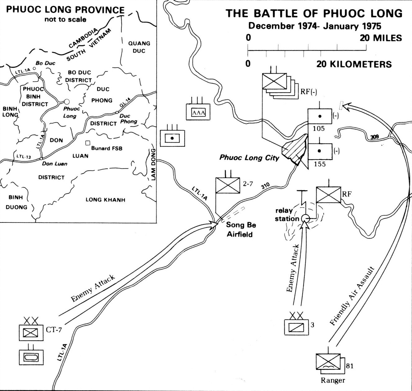
Battle of Phuước Long
On the morning of January 6, 1975, the last South Vietnamese defenders at Phuước Long—survivors of the 81st Airborne Ranger Battalion, their ranks shredded by days of artillery—were overrun. The district fell silent. In Washington, no one moved to intervene. In Hanoi, the silence was the answer they had been waiting for. The battle that had raged across this forested district near the Cambodian border for twenty-six days was relatively small by Vietnam War standards, yet its consequences were seismic. Phuước Long became the proof that the United States had truly left the war behind, and the rehearsal for the offensive that would end South Vietnam forever.
The Test No One Could Afford to Fail
Phuước Long sat roughly 120 kilometers north of Saigon, a district of jungle-covered hills anchored by Bà Rá Mountain and threaded by Route 14, a critical artery linking the Ho Chi Minh Trail to North Vietnamese forces further south. For the Army of the Republic of Vietnam, Phuước Long was part of the III Corps defensive shield protecting the capital and the populous southern provinces. For the People's Army of Vietnam, it was a chokepoint. ARVN units there could disrupt supply lines running from the Central Highlands to the Mekong Delta, leaving northern forces in the south isolated and hungry for materiel. When the PAVN 4th Army Corps launched its campaign on December 12, 1974, it carried three objectives: test whether America would honor Richard Nixon's promises of military retaliation, gauge the combat readiness of the ARVN, and seize the transportation routes that had strangled their logistics for years.
Twenty-Six Days on Bà Rá Mountain
The offensive unfolded in stages, tightening like a noose. The 271st Regiment struck first at Bù Đốp on December 14, overwhelming the ARVN 362nd Security Battalion in two hours. Then came a pause as forces repositioned. On New Year's Eve, the Republic of Vietnam Air Force flew more than 50 bombing sorties against PAVN positions at the foot of Bà Rá Mountain, but the North Vietnamese rolled out long-range anti-aircraft guns that grounded the pilots long enough for the 78th Special Forces Battalion to seize the summit. With Bà Rá's high ground in their hands, PAVN artillery could reach every corner of Phuước Long. Colonel Do Cong Thanh reorganized his battered defenders, shifting headquarters to Camp Le Loi, but each day brought the perimeter closer to collapse. Helicopter-borne reinforcements from the 8/5th Infantry Division were driven back by the 210th Air-Defense Regiment. Supply drops landed in enemy hands. By January 4, Lieutenant General Dư Quốc Đống ordered the 81st Airborne Ranger Battalion airlifted in as a last resort—and PAVN artillery decimated them on the landing zone, destroying two companies' worth of soldiers almost immediately.
The Silence from Washington
What made Phuước Long different from dozens of other battles in a war that had consumed millions of lives was what happened afterward—or rather, what did not. The United States Congress had repeatedly voted against additional aid for South Vietnam, and President Gerald Ford's requests for emergency funding went nowhere. When an entire South Vietnamese province fell to a full-corps assault and Washington did nothing, Hanoi's leadership received the clearest possible signal. The political calculation that had sustained South Vietnam—the belief that American airpower would return in extremis—was revealed as a bluff. North Vietnamese planners took the lesson directly into their next campaign. The 1975 Spring Offensive, launched just weeks later, moved with a speed and confidence that the Battle of Phuước Long had made possible. Saigon fell on April 30, 1975, less than four months after the last defenders at Phuước Long were overrun.
The Cost of a Rehearsal
The numbers from Phuước Long carry the weight of the human reality behind them. More than 1,000 South Vietnamese soldiers were killed in action; 2,444 were captured. The 250-man 81st Airborne Ranger Battalion lost over 150 soldiers in its doomed last-ditch deployment. Roughly 850 ARVN troops were evacuated during the final night. On the North Vietnamese side, the 4th Army Corps suffered approximately 1,300 killed or wounded. Beyond the casualty figures, the battle reshaped the strategic map. The PAVN could now connect supply lines from the Ho Chi Minh Trail through the Central Highlands all the way to the Mekong Delta, placing unbearable pressure on a South Vietnamese military already starved of American supplies. On January 10, 1975, President Nguyễn Văn Thiệu called on the people of South Vietnam to pray for Phuước Long and to renew their determination to retake the district. The district was never retaken.
A Landscape of Memory
Today, Bình Phuước Province—the administrative region that absorbed the old Phuước Long district—is a place of rubber plantations and cashew orchards spreading across the red-earth hills that once shook with artillery. Bà Rá Mountain, the high ground whose capture sealed the defenders' fate, rises above the canopy as a provincial park. The jungle has long since reclaimed the foxholes and gun positions. From the air, the landscape offers few clues to what happened here in the winter of 1974-75—just the green roll of forested highlands tapering toward the Cambodian border, the same terrain that made Phuước Long so strategically vital and so difficult to defend. The battle rarely appears in the broader narrative of the Vietnam War's final act, overshadowed by the drama of the Spring Offensive and the fall of Saigon. But for the soldiers on both sides who fought across these hills, and for the strategists in Hanoi and Washington whose calculations the battle confirmed, Phuước Long was where the war's ending became inevitable.
From the Air
Located at 11.85°N, 107.00°E in Bình Phuước Province, roughly 120 km north of Ho Chi Minh City. Bà Rá Mountain (723 m) is a visible landmark rising above the surrounding jungle canopy. The area sits near the Cambodian border amid rolling, forested highlands. Nearest major airport is Tan Son Nhat International Airport (VVTS) in Ho Chi Minh City. Bien Hoa Air Base (VVBH) is also nearby to the south.