Battle of Pickett's Mill
Brigadier General William Babcock Hazen glanced at his staff officer Ambrose Bierce, and Bierce instantly knew that a "criminal blunder" was about to happen. It was 4:30 in the afternoon on May 27, 1864, in the dense forests of Paulding County, Georgia. Hazen's 1,500-man brigade had been ordered to advance alone against entrenched Confederate positions near a north-flowing creek named after Malachi Pickett's grist mill. The woods were so thick that officers navigated by compass. Hazen had expected the entire division to attack together. Instead, his single brigade was about to assault unsupported, into terrain his commanders had barely reconnoitered. Every mounted officer sent his horse to the rear and went forward on foot. They knew what was coming.
Sherman's Gamble in the Georgia Woods
By late May 1864, William Tecumseh Sherman's Atlanta campaign had settled into a deadly chess match. Sherman commanded three armies totaling over 100,000 men, pushing south against General Joseph Johnston's Confederate Army of Tennessee, which fielded roughly 65,000 to 75,000 troops. After compelling Johnston to fall back to the strong defenses at Allatoona Pass, Sherman refused a frontal assault and instead attempted a wide sweep around the Confederate western flank. Johnston anticipated the move, shifting his forces southwest to block it. On May 25, Sherman's first thrust was defeated at New Hope Church, a place Union soldiers grimly renamed the "Hell Hole" after suffering 1,665 casualties in three hours of fighting that ended in a thunderstorm. Both sides entrenched. Sherman then ordered Major General Oliver Otis Howard's IV Corps, supported by other formations, to find and turn Johnston's right flank. It was a sound idea on a map. The terrain told a different story.
Navigating by Compass
Howard withdrew Thomas J. Wood's division from its freshly dug trenches at dawn on May 27 and formed it into a column of brigades -- six lines of men, one behind the other. The forests were so dense that Wood gave the colonel of his lead regiment a compass to guide the march. A supporting division under Richard Johnson formed into a similar column. After marching through the woods, Howard ordered both columns to wheel right and prepare to attack. Skirmishers discovered entrenched Confederates ahead, so Howard shifted the assault point farther north. He assigned Brigadier General Nathaniel McLean's brigade to support Wood's right flank -- a fateful choice. Howard and McLean carried a bitter grudge between them dating to the Battle of Chancellorsville, and historian Albert Castel later wrote that "of all the brigade commanders in Sherman's army, a worse one to assist in Howard's attack could not have been found." Meanwhile, Johnston had transferred Patrick Cleburne's division to his extreme right flank, deploying Granbury's Texas brigade and Govan's Arkansas troops along a ridgeline above a ravine.
Fifty Minutes of Slaughter
At 4:30 p.m., Wood sent Hazen's brigade forward alone. His men pushed through about 1,000 dismounted Confederate cavalrymen deployed in a thin skirmish line, forcing them back to a ravine. Beyond it rose a ridge. As Hazen's soldiers surged toward it, Granbury's Texans reached the crest just ahead of them. The Confederates took cover and opened devastating fire. Some of Hazen's men shouted "Ah, damn you, we have caught you without your logs!" as they rushed forward, but they were stopped cold. Hazen swung his second-line regiments toward a cornfield on the left. Govan sent the consolidated 8th and 19th Arkansas Infantry to shore up the cavalry. Cleburne deployed Lowrey's brigade on Granbury's right. No units from Johnson's division ever appeared to support the attack. After 50 minutes of taking heavy casualties with his ammunition running low, Hazen's survivors spontaneously withdrew. Wood then sent Gibson's brigade forward, but it was stopped by the same ferocious fire. Scribner's brigade finally arrived on Gibson's left, only to be pinned down by enfilading rifle fire. On Gibson's right, McLean's troops did nothing at all.
The Ravine After Dark
At 6 p.m., word came that Sherman had cancelled the attack 45 minutes earlier. Howard ordered Knefler's brigade forward to hold the line while entrenchments were dug. Knefler's men blundered into the ravine and were struck by intense fire. They pulled back and, joined by regiments from Scribner's brigade, exchanged shots with the Confederates until nightfall. After dark, Knefler's soldiers crept forward to retrieve as many wounded as possible from the killing ground. At 10 p.m., Granbury ordered his Texans to charge into the ravine to drive off any remaining Federals. In pitch darkness, few men were hit by bullets, but the Texans captured numerous Union soldiers and chased others away. That night, a veteran of the Texas brigade was assigned to picket duty in the ravine. At dawn, the carnage sickened him so badly he had to leave. He noted that many of the Federal dead had been shot in the head -- the grim result of defenders firing downhill from a ridgeline at men in a ravine.
The Crime at Pickett's Mill
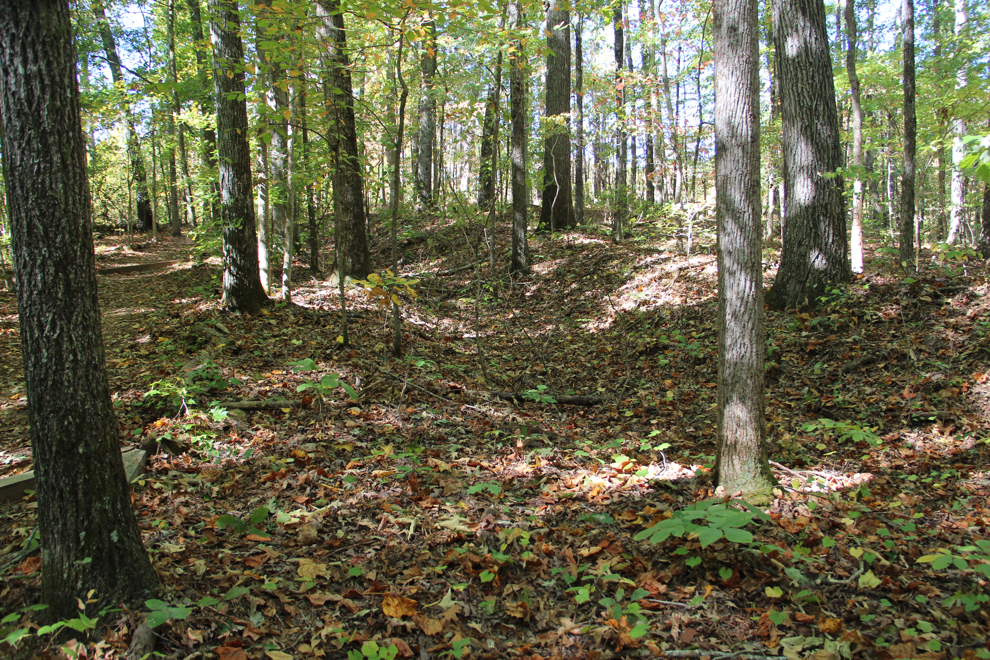
Cleburne's division reported 448 casualties, mostly in Granbury's brigade. Union losses totaled 1,600 killed, wounded, and missing. The ratio of killed to wounded was abnormally high -- the Confederates found one corpse with 47 bullet holes. Hazen's brigade alone suffered 467 casualties, Gibson's lost 681, and Knefler's lost 250, mainly prisoners. The battle was overshadowed by the larger campaign and largely forgotten. But Ambrose Bierce, who served as a topographical engineer on Hazen's staff and watched the disaster unfold, never forgot. He wrote an account titled "The Crime at Pickett's Mill" that stands as one of the most searing eyewitness descriptions of Civil War combat. Today the battlefield is preserved as Pickett's Mill Battlefield Historic Site, a Georgia state park at 4432 Mount Tabor Church Road in Dallas, Georgia. The earthworks used by both sides remain visible. Hiking trails wind through the same dense woods where soldiers navigated by compass, and the ravine where so many men fell is still there, quiet now, the creek running past Malachi Pickett's long-vanished grist mill.
From the Air
Located at 33.98°N, 84.76°W in Paulding County, Georgia, approximately 30nm west-northwest of Atlanta. The battlefield sits in hilly, heavily forested terrain typical of the Georgia Piedmont, along a creek that feeds Pumpkinvine Creek. Look for the preserved state park clearing amid dense woodland -- the site is at 4432 Mount Tabor Church Road near Dallas, Georgia. The terrain drops into ravines that were critical to the battle's outcome. Nearby airports: Cobb County Airport-McCollum Field (KRYY) approximately 15nm east; Cartersville Airport (KVPC) approximately 20nm north; Hartsfield-Jackson Atlanta International (KATL) approximately 35nm southeast. Recommended viewing altitude 2,000-4,000 ft AGL to appreciate the ridgeline and ravine terrain. The surrounding area includes the New Hope Church and Dallas battlefields from the same May 1864 campaign.