Battle of Poelcappelle
The rain returned on October 7th and did not stop. By the time British and Australian troops launched their assault on October 9th, 1917, the Flanders countryside had transformed into something between liquid and solid, a porridge of mud that swallowed men, horses, and artillery alike. The Battle of Poelcappelle would become the moment when nature itself seemed to conspire against the attackers, ending a string of British victories and revealing the brutal limits of industrial warfare in the most hostile terrain imaginable.
The Curse of Passchendaele Ridge
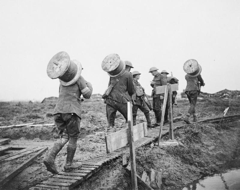
The objective seemed tantalizingly close: Passchendaele village and its commanding ridge, visible from British lines. The previous weeks had brought genuine success. The Battle of Broodseinde on October 4th had been called the first of the "Black Days" of the German Army, with prisoners surrendering readily and German commanders privately despairing. Field Marshal Haig believed the German 4th Army was close to collapse. But between the British guns and their targets lay a wasteland created by years of shelling, and the autumn rains were turning shell craters into death traps. Troops from the 66th Division described the ground behind their lines as a "porridge of mud." Duck-board tracks laid toward the front were trampled by pack animals and sank into the mire. Artillery pieces slipped from improvised platforms. Shells fired into the soft ground were simply swallowed, their explosions muffled and ineffective.
An Army That Could Not Arrive
The attack was scheduled for 5:20 AM on October 9th. But in the darkness and rain, entire battalions became lost in the featureless landscape. Both the 66th and 49th Divisions reported that some units would not reach the jumping-off line in time. The 197th Brigade's soldiers would be late to a man. Staff officers were sent to hurry forward anyone capable of moving faster, abandoning unit cohesion for the desperate need to have bodies in place when the barrage began. When zero hour came, scattered groups of exhausted soldiers stumbled forward behind a creeping barrage they could barely see, fired by artillery that was itself struggling to function. Field batteries that should have provided the protective curtain of fire were stuck miles behind their intended positions, their platforms improvised from whatever could be found to keep guns from sinking.
The Pillboxes of Bellevue
German concrete pillboxes dotted the ridge, their machine guns commanding fields of fire across the waterlogged approaches. The Bellevue strongpoint proved particularly deadly. Infantry from the 49th Division became trapped in the swamps astride the Ravebeek stream, only scattered parties making it across. Those who did found themselves facing uncut barbed wire and withering fire from positions the British artillery had failed to neutralize. One attack got to within yards of Bellevue before being driven back. In the Ravebeek valley, wounded men slipped into water-filled shell holes and drowned. An Australian officer reported finding soldiers who had died not from wounds but from exhaustion and exposure, their bodies half-submerged in the mud that had claimed them.
Success on the Flanks, Failure at the Heart
The battle was not uniformly disastrous. In the north, near Houthulst Forest, the Guards Division and French forces achieved their objectives with relatively few casualties, the ground there less churned by previous fighting. The 29th Division, including the famous Newfoundland Battalion, crossed the Broembeek stream and captured their objectives. But on the main ridge, where the prize of Passchendaele beckoned, the attack had failed. A patrol from the 197th Brigade briefly found Passchendaele village empty and reached the blue line objective, only to be driven back by machine gun fire from exposed flanks. By nightfall, after German counter-attacks, most British units were back where they had started. The German official history called it a costly defensive success.
The Weight of Exhaustion
Crown Prince Rupprecht of Bavaria, commanding the German forces, wrote privately of the "oppressive superiority" of British artillery despite his army's defensive success. But the strain showed on both sides. German General Sixt von Armin issued orders that "the sternest measures" be taken against soldiers drifting to the rear. British casualties in the 66th and 49th Divisions alone approached several thousand. At least three men would receive the Victoria Cross for their actions that day, including Corporal William Clamp, Private Frederick Dancox, and Sergeant John Molyneux. The Battle of Poelcappelle did not end the Third Battle of Ypres, but it ended the string of September victories. Three days later, the First Battle of Passchendaele would fare little better. The village would not fall until Canadian troops finally captured it on November 6th, in conditions that had only grown worse. The fields around Poelcappelle remain farmland today, the mud long since drained and cultivated, hiding the shell holes that once swallowed an army.
From the Air
Located at 50.922N, 2.963E near the village of Poelcappelle in West Flanders, Belgium. The battlefield lies northeast of Ypres (Ieper) along what was the Ypres Salient. From 2,000 feet, the flat Flemish plain reveals little of the 1917 fighting, though military cemeteries dot the landscape. The Passchendaele ridge is visible to the east. Nearest major airport is Ostend-Bruges International (EBOS), approximately 35km northwest. The Menin Road (N8) provides ground reference, running from Ypres toward Menen.