Battle of Santa Rosa Island
Fort Pickens never surrendered. That simple fact makes it remarkable among Southern fortifications during the Civil War -- one of only four forts in Confederate territory that remained in Union hands from start to finish. The story of how it stayed that way begins with a lucky absence. In January 1861, the fort's commander, Major John H. Winder, was a secessionist who would likely have handed it over to the rebellion. But Winder happened to be away from his post, and the garrison fell to Lieutenant Adam J. Slemmer, who immediately began stockpiling arms from nearby military installations and preparing to hold the western tip of Santa Rosa Island against whatever came next.
A Forty-Mile Ribbon of Sand
Santa Rosa Island stretches forty miles along the Florida panhandle, a slender barrier island just thirty miles from the Alabama state line. Fort Pickens commands its western end, a massive brick-and-mortar pentagonal fortification built between 1829 and 1834 to guard the entrance to Pensacola Bay. By the fall of 1861, the Union garrison had grown from Slemmer's single artillery company to a substantial force drawn from the 1st, 2nd, and 5th U.S. Artillery and the 3rd U.S. Infantry, all under Colonel Harvey Brown of the 5th Artillery. The 6th New York Volunteer Infantry, a colorful Zouave regiment commanded by Colonel William Wilson, camped outside the fort's walls a short distance to the east -- exposed and vulnerable.
After Midnight
In the early hours of October 9, 1861, Brigadier General Richard Heron Anderson loaded 1,200 Confederate troops onto two small steamers and crossed from the mainland to Santa Rosa Island. They landed on the north beach roughly four miles east of Fort Pickens and split into three columns. The approach march covered about three miles through the darkness before the Confederates fell upon the sleeping camp of the 6th New York Volunteers. The Zouaves were routed. Camp Brown was overrun and largely destroyed, which was the raiders' primary objective. But Anderson had a grander ambition: he adopted a defensive position, hoping to draw the Union forces out of Fort Pickens and into a fight in the open.
The Counterattack
Colonel Brown did not take the bait. Instead, he gathered reinforcements from the fort's garrison and launched a measured counterattack against the Confederate positions. The fighting pushed Anderson's troops back toward the beach. With Union forces pressing their advantage and the element of surprise long gone, the Confederates re-embarked on their steamers and withdrew to the mainland. The raid was over. Union losses totaled 14 killed, 29 wounded, and 24 captured or missing, including Major Israel Vogdes of the 1st Artillery, who was taken prisoner. Confederate casualties were reported by General Braxton Bragg as 30 to 40 killed and wounded, though a Confederate newspaper found days later claimed total casualties of 175. General Anderson himself was severely wounded in the fighting.
A County Renamed
Among the Confederate dead was Captain Richard Bradford, the first officer from Florida killed during the Civil War. His death carried enough significance that New River County, Florida, was renamed Bradford County in his honor just two months later, in December 1861. The renaming speaks to how early and how personal the war became along the Gulf Coast. Though the Battle of Santa Rosa Island was a relatively small engagement, it demonstrated that the Confederacy could not easily dislodge Union forces from their coastal strongholds -- a strategic reality that would persist throughout the war. Fort Pickens remained in Federal hands until the conflict's end.
Sand, Sea, and Memory
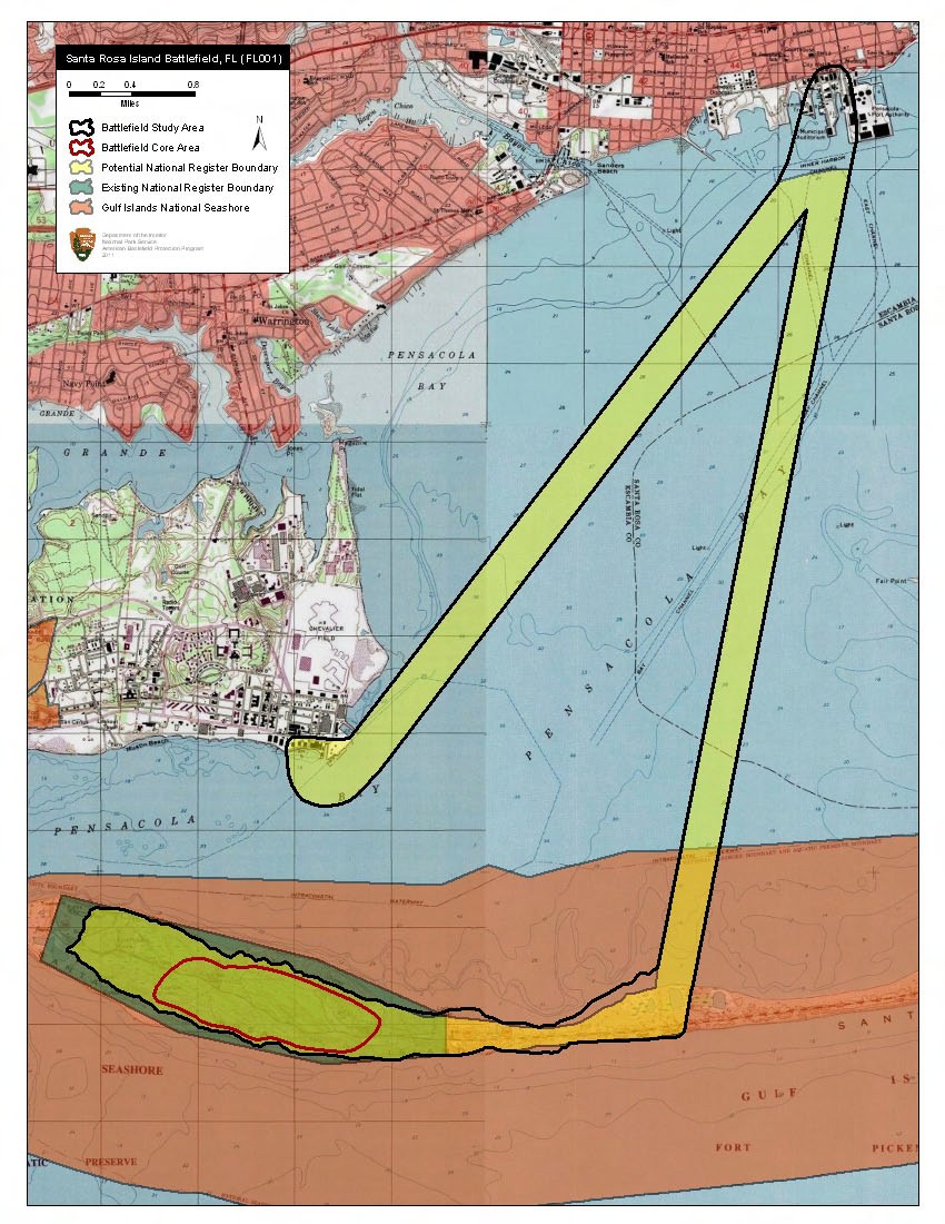
Today Fort Pickens and the battle site are preserved within the Gulf Islands National Seashore, a chain of barrier islands and coastal areas stretching from Mississippi to Florida. The fort's brick casemates still stand at the western tip of Santa Rosa Island, weathered by salt air and hurricanes but intact enough to walk through. The white sand beaches where Anderson's men landed in the pre-dawn darkness are now popular with swimmers and sunbathers. Pensacola Bay still stretches to the north, and the site of Camp Brown lies somewhere beneath the dunes to the east. The island itself remains what it was in 1861: a long, narrow strip of sand between the Gulf of Mexico and the calmer waters of the sound, shaped and reshaped by every passing storm.
From the Air
The Battle of Santa Rosa Island took place at the western end of Santa Rosa Island, near Fort Pickens, at approximately 30.3242N, 87.2817W. The island is a distinctive 40-mile barrier island clearly visible from altitude along the Florida panhandle. Fort Pickens sits at the extreme western tip. Approach from the north over Pensacola Bay for the best perspective on the island's geography and the fort's defensive position. Nearby airports include Pensacola International Airport (KPNS, 8 nm north) and Pensacola NAS/Forrest Sherman Field (KNPA, 4 nm northwest). The Gulf Islands National Seashore encompasses the area. Recommended viewing altitude: 2,000-4,000 feet AGL for the full island panorama.