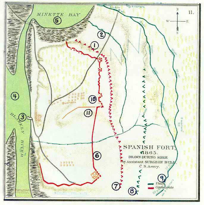
The Battle of Spanish Fort: Twelve Days That Ended the War on Mobile Bay
The war was already lost by the time the shooting started at Spanish Fort. Lee would surrender at Appomattox on April 9, 1865, but on the eastern shore of Mobile Bay, nobody had received that memo. From March 27 to April 8, roughly 2,000 Confederate soldiers under Brigadier General Randall L. Gibson held a network of earthworks and batteries against Major General E.R.S. Canby's 32,000 Union troops. The odds were fifteen to one. The defenders held for twelve days anyway, making Spanish Fort one of the last significant engagements of the American Civil War and the key that finally unlocked Mobile, the Confederacy's last major Gulf Coast port.
The Last Port Standing
By early 1865, Mobile was the only significant Gulf port still in Confederate hands. Admiral David Farragut's fleet had won the Battle of Mobile Bay the previous August, famously damning the torpedoes on its way through the harbor defenses. But controlling the bay was not the same as controlling the city. Mobile sat at the head of the bay, protected on its eastern flank by a chain of fortifications stretching across Baldwin County. Spanish Fort anchored those defenses: Fort Huger, Fort Tracey, Fort McDermott, Fort Alexis, Red Fort, and Old Spanish Fort formed an interconnected line of earthworks and batteries. As long as Spanish Fort held, Union forces could not approach Mobile from the east.
Canby's March Through the Marshes
General Canby assembled a massive force for the campaign. His XIII and XVI Corps crossed the Fish River at Marlow Ferry and advanced north along the eastern shore of Mobile Bay, pushing Confederate skirmishers back into their prepared defenses. A second column of around 13,000 men moved north from Pensacola. On March 27, 1865, Canby's forces converged at Danley's Ferry and immediately began siege operations against Spanish Fort. The terrain favored the defenders: marshes and waterways channeled the Union approach, and the Confederate earthworks provided strong firing positions. Canby's men began digging their own siege lines, inching closer day by day.
Twelve Days in the Trenches
What followed was a grinding siege rather than a dramatic assault. Union forces gradually enveloped Spanish Fort, completing the encirclement by April 1. Confederate defenders fought from their entrenchments, knowing that every day they held was another day Mobile remained in Southern hands. The six Louisiana infantry regiments and five Alabama infantry regiments under Gibson's command were outnumbered beyond any reasonable hope of victory, but they held their ground through constant shelling and probing attacks. Estimated casualties from the siege totaled 657 Union and 744 Confederate soldiers. On the night of April 8, with the position finally untenable, Gibson ordered an evacuation. Most of his force escaped across the bay to Mobile under cover of darkness.
Dominoes to Surrender
Spanish Fort's fall triggered a rapid chain of events. Five miles to the north, Fort Blakeley was already under pressure; Union troops had begun shifting northward as early as April 1, when Spanish Fort's fate became clear. Fort Blakeley fell on April 9, the same day Lee surrendered at Appomattox. With both forts gone, Mobile's eastern defenses collapsed. The Confederate Army of Mobile evacuated the city, and Union troops entered Mobile unopposed on April 12, 1865. The last major Gulf port had finally changed hands. Today the earthworks at Spanish Fort are preserved as a historic site in Baldwin County, the trenches and battery positions still visible in the landscape as reminders of those twelve days when the outcome of the war had already been decided everywhere except along the shores of Mobile Bay.
From the Air
Located at 30.684°N, 87.916°W on the eastern shore of Mobile Bay in Baldwin County, Alabama. The battlefield sits near the modern town of Spanish Fort, visible from altitude as a wooded area along the bay's eastern shore. Mobile Regional Airport (KMOB) is approximately 15 miles to the west-southwest across the bay. Mobile Bay stretches broadly to the south and west. From 3,000-5,000 feet AGL, the relationship between Spanish Fort and Fort Blakeley (5 miles north) becomes clear, as does the strategic position guarding the eastern approach to Mobile. The I-10 corridor passes near the historic site. The bay's eastern shoreline reveals why this position was so defensible: marshes and waterways still channel movement through the area.