Battle of Te Porere
Te Kooti built his last fortress with a fatal flaw. The loopholes in the earthen walls of Te Porere had no downward angle, which meant that once attackers reached the ditch below the parapet, the defenders could not fire on them without exposing themselves over the wall. On the morning of 4 October 1869, government forces and their kupapa allies discovered this weakness and exploited it methodically, plugging the loopholes with lumps of pumice while digging out the base of the walls. Within hours, Te Kooti's men were dead, fleeing, or captured. The man himself escaped into the bush with a severed finger and a bullet wound - but never again fought from behind prepared fortifications.
The Prophet's Road to the Plateau
Te Kooti Arikirangi was a warrior of the Rongowhakaata iwi who had fought for the colonial government against the Pai Marire religious movement in 1865. His reward for loyalty was suspicion: accused of being a spy, he was arrested and exiled without trial to the Chatham Islands in March 1866, along with 200 Pai Marire prisoners and their families. During his captivity, he developed a new faith - Ringatu - that would sustain his followers through years of war and flight.
In July 1868, Te Kooti and his followers seized a vessel and sailed back to the mainland, landing at Poverty Bay. What followed was a year of running battles: a massacre at Poverty Bay in November 1868 committed in utu for his banishment, a siege and escape at Ngatapa in January 1869, months of guerrilla raids from the Urewera ranges. By mid-1869, having lost the support of the Tuhoe iwi after a punitive government invasion of the Ureweras, Te Kooti moved westward to the Central Plateau around Lake Taupo, gathering reluctant followers from the local Ngati Tuwharetoa - some of whom joined under duress.
Three Redoubts on Volcanic Ground
Te Porere sat on the Central Plateau near the upper reaches of the Whanganui River, in the shadow of Mount Tongariro. Te Kooti's roughly 300 warriors constructed three fortifications during September 1869. The main structure - the upper redoubt - was built in the European military style rather than as a traditional pa, with earthen walls and a western entrance that offered an escape route into the bush. A lower redoubt occupied the west bank of the Whanganui River, consisting of several interconnected trenches. A rifle pit on the east bank served as an observation post.
Cold weather may have slowed the construction, and the fortifications showed it. The ditches around the upper redoubt were incomplete on the north wall and southeast corner. The lower redoubt had cover but lacked depth. And then there was the critical error of the loopholes: built without declination, they were useless against anyone who reached the base of the walls. Whether this was inexperience with European-style fortification or simply the result of time pressure, it would prove decisive.
Surrounded on Three Sides
Lieutenant Colonel Thomas McDonnell commanded the government force - about 100 Armed Constabulary supplemented by several hundred kupapa warriors from Te Arawa, Ngati Kahungunu, Ngati Tuwharetoa, and Whanganui. On the morning of 4 October, they found the village of Papakai abandoned and Te Porere clearly visible two miles to the west. When Ringatu skirmishers approached, McDonnell split his force. Major Te Keepa Te Rangihiwinui's Whanganui warriors took the left flank; McDonnell led the right.
Keepa's men advanced steadily toward the upper redoubt, holding their fire until they were close enough for it to count. The Ringatu skirmishers fell back. On the right, Captain John St George led his Te Arawa kupapa past the rifle pit, across the Whanganui River, and through the lower redoubt. St George was shot through the head as he approached the upper redoubt - one of Te Kooti's lieutenants, Peita Kotuku, later claimed the kill. With the upper redoubt surrounded on three sides and the loophole flaw exposed, the attackers blocked the firing slits with pumice, undermined the walls, and climbed over the parapet to fire directly into the interior.
The Women Who Fought Last
Te Kooti escaped through the western entrance, shielded by female followers, losing a finger to a bullet as he fled into the bush. Thirty-seven of his warriors died inside the upper redoubt; their bodies were buried within its walls. Over twenty prisoners were taken, and of these the fiercest resistance had come from the women - several bore severe wounds from the fighting. Only one male prisoner, Te Wiripo Tohiraukura of Ngati Tuwharetoa, survived to be captured.
Of the attackers, four died, including St George, and four were wounded. Renata Kawepo, a Ngati Kahungunu leader, lost an eye in hand-to-hand combat during the final minutes of the assault. Within days, the government used Te Wiripo as a mediator to secure the surrender of chief Te Heuheu Horonuku, accepting his claim that he had fought under duress.
The Last Major Battle
Te Porere marked the end of an era. Never again would Maori forces defend a prepared position against government troops - the tactic that had defined warfare in New Zealand since the 1840s was finished. Te Kooti reverted to guerrilla tactics, evading pursuit through the North Island's interior for three more years before finding sanctuary in the King Country in May 1872. A decade later, he received a pardon and was allowed to spread the Ringatu faith, though he never returned to Poverty Bay.
The battlefield was declared a National Historic Place on 18 February 1961. Today both the upper redoubt and the lower fortification have been reconstructed and are considered the best-preserved pa site in New Zealand - though, as historians note, they are not the best example of one, since Te Porere was never a traditional pa at all. It was a European-style redoubt built by Maori hands, a hybrid that reflected the tangled allegiances of a war in which Maori fought on both sides.
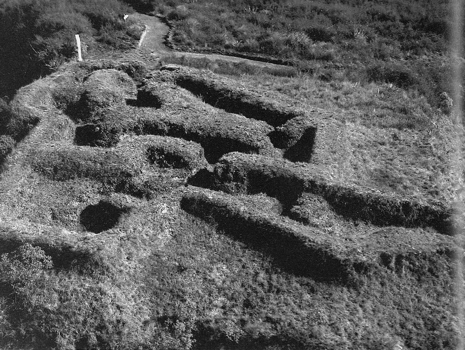
From the Air
Located at 39.05S, 175.59E on New Zealand's Central Plateau, near the upper reaches of the Whanganui River in the shadow of Mount Tongariro (1,978m). The site sits on open tussock and scrubland at roughly 800m elevation, east of Tongariro National Park. From the air, look for Lake Rotoaira to the northeast and the volcanic peaks of Tongariro, Ngauruhoe, and Ruapehu to the south and southeast. The reconstructed earthworks of the upper and lower redoubts may be visible at low altitude. Nearest airports: Taupo Airport (NZAP) approximately 35 km east, Waiouru Military Airfield (NZOU) approximately 40 km south. Volcanic terrain; be alert for restricted airspace around the volcanic peaks.