Battle of the Chateauguay: The 1,530 Who Saved Montreal
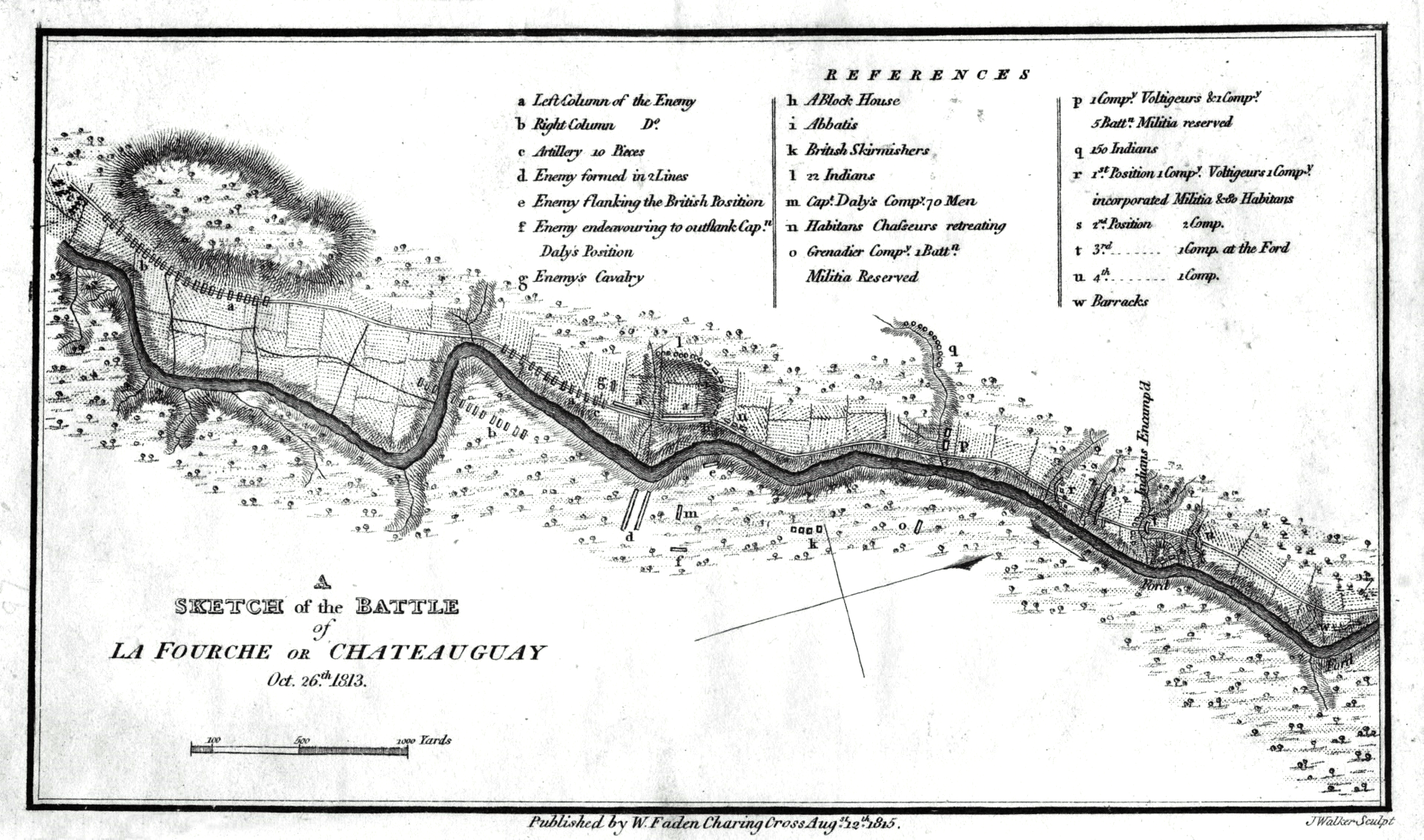
Charles de Salaberry had not bothered to inform his superiors. On 26 October 1813, as an American force of 2,600 regulars pushed down the Chateauguay River toward Montreal, the French-Canadian commander of the outpost defenses was already arranging his 1,530 men behind felled trees and earthen abatis along the riverbank. He positioned Canadian Voltigeurs at the forward lines, placed Mohawk warriors and local militia to guard a critical ford, and waited. When Major-General de Watteville and Governor General Sir George Prevost rode forward to inspect the dispositions, the shooting had already started. De Salaberry had been so confident of victory that he had skipped the formalities entirely.
A Plan to Capture Montreal
The American strategy for autumn 1813 was ambitious: two divisions would converge on Montreal in a pincer movement that could sever Upper Canada from all support. One force would descend the St. Lawrence from Sackett's Harbor; the other would advance north from Lake Champlain. But the plan was undermined from the start by the two men charged with executing it. Major General Wade Hampton, a wealthy southern plantation owner commanding the Lake Champlain division, despised Major General James Wilkinson, who led the Sackett's Harbor force and carried a reputation for corruption and secret dealings with Spain. The two had been feuding since 1808. Hampton initially refused to take orders from Wilkinson, and only reluctantly cooperated after Secretary of War John Armstrong arranged that all communications would pass through the War Department. Hampton's troops at Burlington were raw, his officers untrained, and a brigade of 1,400 New York militia would later refuse to cross the Canadian border altogether.
The Wooded Banks of the Chateauguay
Hampton had originally planned to advance along the direct route north from Lake Champlain, but finding the British garrison at Ile aux Noix too strong and the wells dried up from summer drought, he marched his force west to Four Corners on the Chateauguay River. There he waited for weeks while Wilkinson's expedition prepared. When he finally advanced on 18 October, he found every bridge demolished and trees felled across roads that were little more than tracks. His progress slowed to a crawl. Meanwhile, de Salaberry had organized a remarkable defense. His Canadian Voltigeurs held the forward positions behind an abatis of felled trees. Two companies under the Juchereau Duchesnay brothers, about 100 men, anchored part of the line. Local Beauharnois militia and a small contingent of Abenaki, Algonquin, and Iroquois warriors covered the flanks. Behind the abatis, at a ford across the river, light companies of the Select Embodied Militia stood ready.
A Miserable Night, a Decisive Day
Hampton's plan hinged on a flanking movement. Late on 25 October, he sent 1,500 men under Colonel Robert Purdy through the woods on the south bank to cross at the ford behind de Salaberry's position. Purdy's brigade spent the night stumbling through swampy forest in pouring rain, hopelessly lost. By morning they had found the trail, but inexperienced guides led them to the wrong point on the river. When they finally reached the ford after noon, Captain Daly of the 3rd Select Embodied Militia launched an immediate counterattack while Canadian troops fired from across the river. The Americans fell into confusion. On the north bank, American regulars under General Izard delivered steady, rolling volleys into the abatis -- conventional tactics almost entirely useless against defenders sheltering behind logs and trees. The Canadians replied with precise, individual marksmanship. Lieutenant Pinguet later recounted that his men fired thirty-five to forty rounds each, so well aimed that prisoners reported every shot passing at breast or head height. Hampton's four field guns never came into action.
The Campaign Collapses
The engagement lasted only hours, but its consequences rippled across the entire autumn campaign. Canadian losses were remarkably light: two killed, sixteen wounded, and four missing. American casualties stood at 23 killed, 33 wounded, and 29 missing. Hampton called a council of war that unanimously concluded a renewed advance was hopeless. He retreated to Plattsburgh, refusing Wilkinson's subsequent orders to advance to Cornwall with supplies. Wilkinson's own force was defeated at the Battle of Crysler's Farm on 11 November, but he used Hampton's refusal as a pretext to abandon his advance. The grand campaign to capture Montreal was finished. Hampton had submitted his resignation the day before the battle. He never served in the field again.
A Legend Takes Shape
Governor General Prevost's official dispatch inflated the Canadian achievement considerably, claiming 300 Canadians had routed 7,500 Americans. The real numbers were less dramatic but still remarkable: a mixed force of regulars, militia, Voltigeurs, and Indigenous warriors had turned back an army nearly twice their size through superior positioning and marksmanship. The battle became legendary in Canadian folklore, a founding story of national defense. De Salaberry was later made a Companion of the Bath. The Mohawk warriors from Kahnawake and Kanesatake who fought that day received Military General Service Medals decades later, in 1847 -- their names preserved in parish registers that still survive in the National Archives of Quebec. The battlefield was designated a National Historic Site of Canada in 1920, a quiet stretch of river where the fate of Montreal was decided in an afternoon.
From the Air
Located at 45.16N, 73.93W along the Chateauguay River in Quebec's Monteregie region, roughly 50 km southwest of Montreal. The battlefield sits in a rural, wooded area along the riverbank. From altitude, the Chateauguay River is visible winding through flat agricultural land toward its confluence with the St. Lawrence. Nearest airports include Montreal-Pierre Elliott Trudeau International (CYUL) approximately 45 km northeast and Les Cedres (CSP5) nearby. Best viewed at 2,000-3,000 ft AGL to appreciate the river corridor where the battle took place.