Battle of Tjiater Pass
Fortifications designed for a regiment were held by a single company. That mismatch -- between what the defenses required and what the defenders could spare -- defined the Battle of Tjiater Pass before the first shot was fired. In early March 1942, on the volcanic foothills of Tangkuban Perahu in West Java, roughly 2,000 Japanese soldiers under Colonel Toshinari Shoji attacked undermanned Dutch colonial positions guarding the mountain road to Bandung. Three days later, the pass had fallen, and with it, any realistic hope of holding the Dutch East Indies.
The Road Through the Mountains
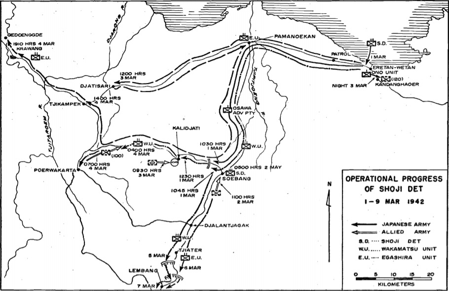
After winning the Battle of the Java Sea on 27 February 1942, Japanese forces landed across Java. Shoji's detachment came ashore at Eretan Wetan, near present-day Indramayu, at dawn on 1 March and quickly seized the Kalijati airfield. From Japanese-controlled Subang, two routes led to the Bandung plateau: one through Purwakarta, and another through the narrow, less-developed Tjiater Pass on the slopes of the Tangkuban Perahu volcano. Dutch counterattacks on 2 and 3 March to retake Kalijati had failed, burning through Allied reserves. Now the "Bandoeng Group" under Major General Jacob Pesman -- about 9,000 men spread across multiple defensive positions -- had to hold the mountain passes long enough for the retreating "West Group" from Batavia and Buitenzorg to arrive. Reinforcements were not expected until 6 or 7 March, and would not be combat-ready until the 10th. Every day mattered.
Pillboxes in the Fog
The Tjiater fortifications consisted of trenches, two lines of casemates, and barbed wire, with the first defensive line stretching about two kilometers in front of a ravine. It had been designed for a full infantry regiment. When the battle began around noon on 5 March, a single battalion held it -- reinforced by two platoons and some support units, but still far below the intended garrison. Construction on the secondary line at the southern end of the pass remained unfinished, and a shortage of laborers after the invasion had left even the northern works only partially operational. Japanese vanguard light tanks probed the Dutch pillboxes and a lone 5-cm gun. The gun was destroyed within three hours. Dutch soldiers retreated from the forward positions, blowing a bridge over the ravine as they fell back. When the main first line opened up with mortars and machine guns, the Japanese answered with their own, and within half an hour infantry had infiltrated unmanned sections, threatening to encircle the defending company. By 4 PM, the first line belonged to Japan.
A Traffic Jam and a Massacre
Pesman sent his reserves toward the pass, but a traffic jam on the approach road delayed them. By the time reinforcements reached the area, Japanese soldiers had already infiltrated positions between the lines, blocking access to the second defensive position. Dutch troops in the second line were eventually evacuated overnight, and a new defensive line was improvised farther back, manned by some 950 soldiers. Behind them stood just 400 inexperienced troops guarding the southern exit of the pass. On 6 March, thick morning fog gave the Japanese cover for a surprise assault on the western section. Two waves were repelled, but a third -- backed by mortar fire and three tanks -- broke through two infantry companies. Between 30 and 50 Dutch soldiers died in the fighting. Another 75 who surrendered were massacred by Japanese forces, leaving only six survivors. A 1948 accounting tallied 120 dead from those two companies alone. Colonel W.J. de Veer, who commanded the pass fortifications, was killed leading a counterattack that afternoon. With their commander dead and the defenses outflanked, the remaining Dutch troops withdrew toward Lembang.
The White Flag at Lembang
By nightfall on 7 March, Japanese forces occupied Lembang. At about 7:30 PM, a Dutch messenger arrived carrying a flag of truce. The Dutch had intended to discuss only a local surrender of troops around Bandung, but Japanese Sixteenth Army Commander Hitoshi Imamura demanded something far larger: the total capitulation of all Allied forces in the Dutch East Indies. Governor-General Tjarda van Starkenborgh Stachouwer and Dutch military commander Hein ter Poorten initially refused. Australian Brigadier Arthur Blackburn briefly considered a guerrilla campaign but abandoned the idea. Bandung was full of refugees, and the prospect of urban fighting among them proved decisive. On noon of 9 March 1942, Dutch authorities broadcast their general surrender. Formal instruments were signed less than three hours later at the Kalijati airfield -- the same strip whose loss had set the entire collapse in motion just nine days earlier.
What the Pass Decided
Tjiater Pass was not the largest engagement of the Dutch East Indies campaign, but it was the hinge. A numerically inferior Japanese force -- roughly 2,000 to 2,400 men against a scattered Dutch garrison of 9,000 -- exploited air superiority, superior training, and the defenders' inability to concentrate their strength. The fortifications that should have held were undermanned from the start. Reinforcements arrived too late and too slowly. Air raids shattered morale before ground assaults shattered lines. The pass itself, now called Ciater in Subang Regency, sits among tea plantations and hot springs on the northern slopes of the Tangkuban Perahu volcano. The casemates and trenches are largely gone. What remains is the consequence: the fall of Tjiater opened the road to Bandung, and Bandung's surrender ended three and a half centuries of Dutch colonial rule in the East Indies -- replaced, for the next three years, by Japanese occupation.
From the Air
Located at 6.77°S, 107.63°E on the northern slopes of Tangkuban Perahu volcano in West Java, Indonesia. The pass sits at moderate elevation in the foothills south of Subang, along the mountain road to Bandung. Nearest major airport is Husein Sastranegara International Airport (WICC) in Bandung, approximately 25 km to the south. The area is characterized by volcanic terrain with tea plantations. Best viewed at 5,000-8,000 ft altitude for the mountain pass terrain context.