Bazaruto Archipelago National Park
From the air, the five islands look like pale green brushstrokes on a canvas of impossible blue. Bazaruto, Benguerra, Magaruque, Santa Carolina, Bangue — they arc along the Mozambican coast like stepping stones dropped between the mainland and the open Indian Ocean. Together they form the Bazaruto Archipelago National Park, the only official marine reserve in Mozambique and one of the largest protected marine areas in the Indian Ocean. The park encompasses not just the islands themselves but the coral reefs, seagrass meadows, and deep channels surrounding them. It is a place where dugongs graze in the shallows and humpback whales breach in the channels, and where the word "pristine" has not yet become marketing fiction.
The Last Dugongs
The waters of the Bazaruto Archipelago shelter the largest dugong population along the entire eastern African coast. These gentle, slow-moving marine mammals — sometimes called sea cows — graze on the seagrass beds that thrive in the warm, shallow waters between the islands and the mainland. While their numbers here are modest compared to populations along the Australian coast or in the Persian Gulf, the Bazaruto dugongs may represent the only viable population remaining in the southwestern Indian Ocean. They were historically hunted and eaten as a delicacy in the region, and their survival depends on the continued health of the seagrass habitat the park protects. Four species of sea turtle also frequent these waters — green, hawksbill, loggerhead, and leatherback — with loggerheads nesting on the island beaches. The archipelago's role as a refuge for these species makes it a linchpin of marine conservation across the western Indian Ocean.
Reefs, Dunes, and Deserted Beaches
The leeward side of the island chain is surrounded by calm turquoise water. The windward side is another world entirely — wild, wave-pounded, and largely deserted. Between these two faces, the park's ecosystems stack in layers of increasing improbability. Coral reefs host thousands of fish species and support marine mammal populations. Sand dunes climb the eastern shores, some among the tallest on any barrier island in the world. Tidal flats and inland saline lakes provide habitat for dozens of seabird species. Mangrove swamps edge the sheltered coasts, filtering sediment and serving as nurseries for juvenile fish. On the islands themselves, grasslands give way to patches of freshwater wetland where blue monkeys, harnessed bushbuck, and red forest duiker move through vegetation that seems impossibly lush for a sand island in the Indian Ocean.
Beneath the Surface
Diving in the Bazaruto Archipelago means entering water with visibility that can reach 40 meters. Sites range from 12 to 30 meters in depth, and the uncrowded conditions — a consequence of the archipelago's relative remoteness — mean encounters with marine life feel personal rather than performative. Dolphins, whale sharks, manta rays, and spotted eagle rays patrol the reefs. Humpback whales pass through the deeper channels during their migration. The coral itself is in remarkable condition, protected from the destructive fishing practices and coastal development that have degraded reefs across much of the Indian Ocean. For those who prefer to stay above the waterline, traditional dhow safaris offer a slower way to experience the archipelago. These wooden sailing vessels glide between the islands on routes that have changed little in centuries, their crews preparing fresh seafood on board as the sails fill with the trade winds.
A Conservation Gamble
The original Bazaruto National Park was established in 1971 by the Portuguese colonial government, but it encompassed only Benguerra, Magaruque, and Bangue. Bazaruto Island itself was excluded. After Mozambican independence and the devastating civil war that followed, proposals to expand the park gained momentum through a partnership with the World Wildlife Fund, funded by the European Union. In 2001, the reorganized Bazaruto Archipelago National Park brought all five islands and their surrounding waters under protection. The government has monitored island development carefully, permitting only eco-friendly lodges rather than massive resort hotels. Accommodation on the islands remains expensive — a deliberate trade-off that limits tourist impact. For budget travelers, the mainland town of Vilanculos provides affordable alternatives and day-trip access by dhow or motorboat. The park's challenge remains the tension between conservation and the livelihoods of the roughly 2,500 people who live on the islands, mostly Xitsonga-speaking communities whose families have fished these waters for generations.
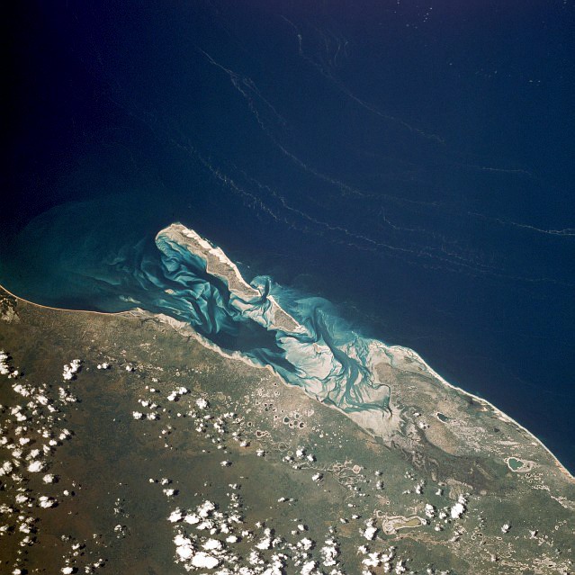
From the Air
The Bazaruto Archipelago is located at approximately 21.67°S, 35.47°E, off the coast of Vilanculos in southern Mozambique. From cruising altitude, the five islands are clearly visible as a north-south chain separated from the mainland by Bazaruto Bay. The turquoise shallow water and coral reef systems contrast sharply with the deeper blue of the open Indian Ocean to the east. Massive sand dunes are visible on the eastern shores of Bazaruto Island. Vilanculos International Airport (FQVL) is the nearest airfield on the mainland. Bazaruto Island has an unpaved airstrip. Seaplane operations connect from Maputo. Clear visibility during the dry season (March–November) offers the best aerial views.