Where the Dragon Ladies Fly
The pilots who fly from Beale Air Force Base wear pressure suits. They have to. The Lockheed U-2 Dragon Lady, the reconnaissance aircraft that has defined this base since the mid-1960s, operates above 70,000 feet - so high that the sky turns black and the curvature of the Earth becomes visible. At that altitude, the difference between the aircraft's stall speed and its maximum speed narrows to a razor-thin margin that pilots call the "coffin corner." One wrong input and the plane either stalls or tears itself apart. Every U-2 mission begins and ends at Beale, forty miles north of Sacramento in the rolling grasslands of Yuba County, where the base occupies nearly 23,000 acres of terrain that has seen Native American habitation, Gold Rush mining, armored division training, intercontinental ballistic missiles, and now the highest-flying manned aircraft in the American arsenal.
From Grassland to Garrison
Before the military arrived, this land was grassland and rolling hills, dotted with the remnants of the 19th-century mining town of Spenceville. Native Americans had lived here far longer - their mortar bowls, carved into bedrock for grinding acorns and seeds, still lie embedded in a shallow stream on the base. In 1942, Marysville city officials lobbied the War Department to establish a training facility in the area. The government purchased 87,000 acres and built Camp Beale, named for Edward Fitzgerald Beale, a Navy lieutenant turned California frontier explorer who had carried news of the Gold Rush to Washington in 1848. The 13th Armored Division trained here, the only unit of its kind entirely trained in California. German prisoners of war were held on the grounds, and their prison cells still stand - the walls bearing drawings that POWs made using the heels of their boots as charcoal sticks, images that remain surprisingly vivid more than eighty years later.
Titans in the Hills
Camp Beale became an Air Force base on April 1, 1951, and by the late 1950s it was deep in the Cold War. Strategic Air Command established the 4126th Strategic Wing in 1959, dispersing B-52 Stratofortress bombers across more bases to make them harder to destroy in a Soviet first strike. KC-135 Stratotanker aerial refueling aircraft arrived that same year. Then came the missiles. The Air Force announced plans for HGM-25A Titan I intercontinental ballistic missile installations near Beale, and the 851st Strategic Missile Squadron eventually operated three complexes - one near Lincoln, one near Live Oak, and one near Chico - each housing three nuclear-tipped missiles in underground silos. The Titan I sites were deactivated by March 1965, victims of rapid technological obsolescence, but their underground structures remain scattered across the Sacramento Valley in various states of abandonment. Near Lincoln, suburban housing developments now encroach on the concrete bunkers that once held weapons capable of ending cities.
Eyes at the Edge of Space
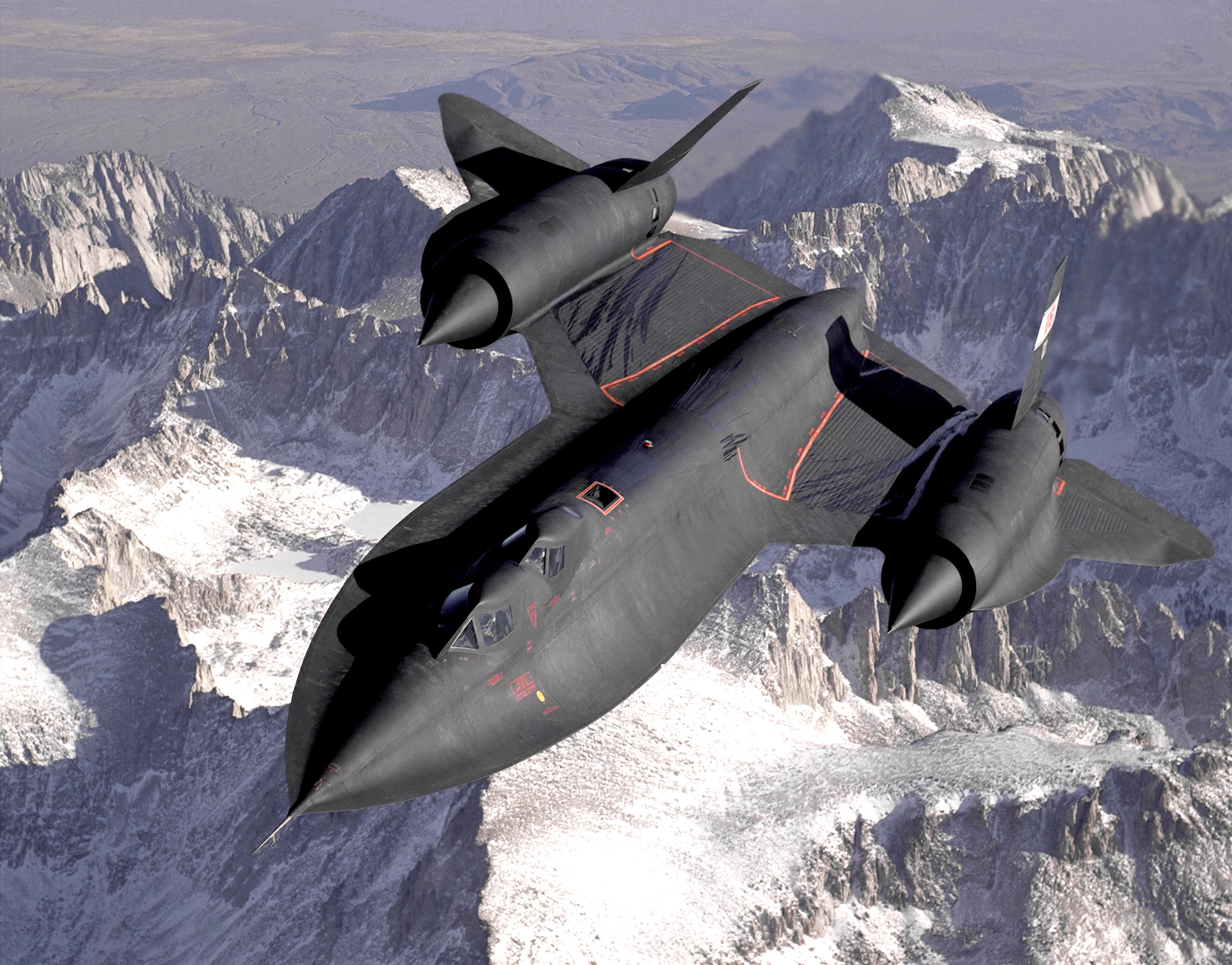
Beale's defining mission arrived in the mid-1960s when the 9th Strategic Reconnaissance Wing relocated here with the SR-71 Blackbird, the fastest manned aircraft ever built. The SR-71 flew from Beale until its retirement in 1998, but the reconnaissance mission continued with the U-2 Dragon Lady, which the 9th Wing still operates today along with the RQ-4 Global Hawk unmanned aircraft. The 9th Reconnaissance Wing, now assigned to the Sixteenth Air Force under Air Combat Command, collects intelligence described as essential for presidential and congressional decisions. The wing's pilots undergo a selection process as demanding as astronaut training, learning to operate in pressure suits at altitudes where the atmosphere barely exists. Beale also hosts the 548th Intelligence, Surveillance, and Reconnaissance Group, which processes imagery and signals data from U-2, Global Hawk, and other platforms, turning raw reconnaissance into actionable intelligence for commanders worldwide.
The Radar That Watches the Pacific
On the outskirts of the base stands a ten-story structure that looks nothing like the rest of the installation. This is the PAVE PAWS radar site, operated by the 7th Space Warning Squadron, a U.S. Space Force unit tasked with detecting sea-launched and intercontinental ballistic missiles aimed at the American West Coast. Two enormous phased-array radar antennas scan the Pacific horizon continuously, feeding detection data to the North American Aerospace Defense Command at Peterson Space Force Base, to Cheyenne Mountain, to U.S. Strategic Command at Offutt Air Force Base, and to the National Command Authorities. It is a Protection Level 1 facility - the highest security designation - and it has been operational since August 1980. The Cold War built it. The world that followed has found no reason to turn it off.
A Base of Layers
Beale today is home to approximately 4,000 military personnel, plus the 940th Air Refueling Wing, an Air Force Reserve unit flying KC-135R Stratotankers. The base maintains 38 documented Native American sites, 45 homestead sites, and 41 World War II sites across its vast acreage. It is a place where the layers do not just coexist but physically overlap - walk along a streambed and you find thousand-year-old grinding stones; drive past base housing and you pass the prison block where German soldiers drew pictures of home; look up and a U-2 climbs toward the stratosphere in near silence, its long wings flexing as it gains altitude. The five gates of the base open onto a landscape that has been continuously repurposed for nearly a century, each era leaving its structures and its ghosts for the next to inherit.
From the Air
Located at 39.136N, 121.436W in Yuba County, California. Beale AFB (KBAB) has a 12,000-foot primary runway (15/33) - note this is an active military installation with restricted airspace (R-2524). Yuba County Airport (KMYV) is 10 miles west in Marysville. Sacramento International (KSMF) is 40 miles south. The base is identifiable by its enormous runway, the distinctive PAVE PAWS radar structure on its western edge, and the rolling grassland terrain. Caution: high-altitude U-2 operations may be active; check NOTAMs. The Sacramento Valley floor is typically clear in summer but subject to dense tule fog in winter months.