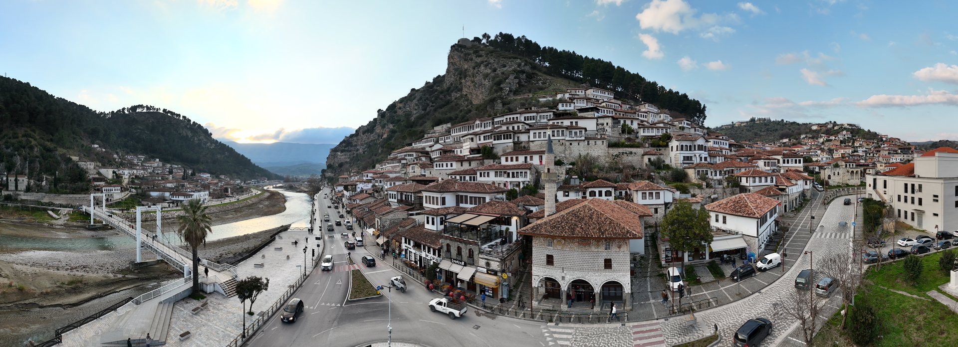
Berat
Count the windows and you will lose track. Stacked up the hillside in tiers of whitewashed stone, the houses of Berat present so many glazed faces to the sun that Albanians long ago stopped trying to number them and simply named the place accordingly: the City of a Thousand Windows. The nickname understates the effect. From across the River Osum, the Mangalem quarter looks less like a neighborhood than a single organism, each house growing out of the one below, their uniform white walls and dark-framed windows repeating upward until the castle walls take over at the crest.
Where Faiths Shared Walls
What makes Berat exceptional among the surviving Ottoman cities of the Balkans is not merely its preservation but its layering. Byzantine churches dating from the 13th century sit within walking distance of Ottoman mosques built from 1417 onward, and neither tradition erased the other. The Kala fortress quarter, perched above it all, still contains working churches alongside the foundations of mosques, a physical record of coexistence that UNESCO recognized in 2008 when it added Berat to the World Heritage List. The town earned its place not as a monument to any single empire but as a rare example of a well-preserved Ottoman-era city where multiple religious and cultural communities left their marks on the same streets, the same stones.
A Castle in the Clouds
Berat Castle crowns the eastern bank of the Osum on a hill that forces even the fittest visitors to earn the view. The climb is steep, threading through the Kala neighborhood where women still sit in doorways making lace for sale. At the top, the reward is panoramic: the river bending below, the Gorica quarter on the opposite hill, and behind everything the snowcapped bulk of Mount Tomorr, which Albanians consider sacred. The castle's inner walls shelter the Onufri Museum, named for the 16th-century Albanian painter whose icons are among the finest in the Orthodox world, their pigments still vivid after five centuries. From this vantage the city reveals its logic. Berat was not built for beauty; it was built for defense, for light, for making the most of a difficult slope. Beauty was simply the result.
Tastes of the Valley
Below the castle walls, the culinary life of Berat unfolds with a specificity that resists generalization. Pilaf me kaposh deti, rice slow-cooked with turkey, reflects the Ottoman heritage of the kitchen. Mont Blanc pastry takes its name not from the Alpine peak but from the white summit of Tomorr visible from every rooftop. Figs and olives thrive in the valley's Mediterranean microclimate, and the local raki, distilled with walnuts as raki me arra, carries a richness that plain grape spirit cannot match. In the Kala quarter, restaurants serve Albanian cuisine on terraces that look straight down onto the river, and a peculiar rose-petal juice appears on menus as casually as water. The food here is not fusion or reinvention. It is the cooking of a place that absorbed influences for centuries and made them its own.
The River Below
The Osum River defines Berat as surely as the castle does. It separates the Mangalem quarter from Gorica, reflects the windows that give the city its name, and connects Berat to the wider landscape of southern Albania. Downstream, the same river carved the spectacular Osum Canyon near Corovode. In Berat itself, the riverbanks serve as the town's promenade, where locals gather at sunset for fresh air and conversation in a ritual that predates any empire. The main boulevard runs along the water, shaded and unhurried, while above it the old town's footpaths climb through flower-draped alleys so narrow that two people cannot walk abreast. Berat sits roughly 70 kilometers south of Tirana, 71 kilometers north of Gjirokaster, and 70 kilometers west of Korce, making it a geographic crossroads of Albanian travel. Yet despite this centrality, it retains the pace of a town that has seen enough history to know there is no rush.
From the Air
Located at 40.70N, 19.95E in the Osum River valley of central Albania. The castle hill and the distinctive white buildings climbing the hillside are clearly visible from the air. Mount Tomorr (2,416 m) rises to the southeast as a prominent landmark. Nearest airports include Tirana International Airport Nene Tereza (LATI), approximately 70 km to the north. Kuçove Air Base (LAKC) is closer, roughly 20 km to the northwest. Best viewed at 3,000-5,000 ft AGL to appreciate the terraced hillside architecture and the river bend.