Bernardo O'Higgins National Park
There are no roads here. No trails to speak of. No towns except for one tiny settlement of 200 people clinging to a rock in the middle of nowhere. Bernardo O'Higgins National Park covers 35,259 square kilometers of Chilean Patagonia - an area larger than Belgium - and almost none of it is accessible to ordinary travelers. This is the realm of the Southern Patagonian Ice Field, the largest body of ice outside the poles and Greenland. Glaciers tongue down from the ice cap into fjords where no ship has a reason to go. Mountains rise from channels that take days to navigate. It is wilderness in the purest sense: land that humans visit but will never tame.
The Ice Field
The Southern Patagonian Ice Field runs for 350 kilometers along the spine of the Andes, straddling the border with Argentina. It is the source of the great glaciers on both sides: Perito Moreno, Upsala, Grey, Pío XI. Some of these glaciers are advancing, most are retreating, but all are fed by the same vast reservoir of ancient ice that has accumulated here for thousands of years.
Pío XI Glacier, within the park, is the largest in the Southern Hemisphere outside Antarctica. It descends from the ice field into Eyre Fjord, a wall of ice 4 kilometers wide and 75 meters tall at its face. Unlike most glaciers worldwide, it's still growing - one of the very few on Earth defying the global trend of retreat. Reaching it requires a multi-day boat journey through channels that see maybe a few dozen visitors per year.
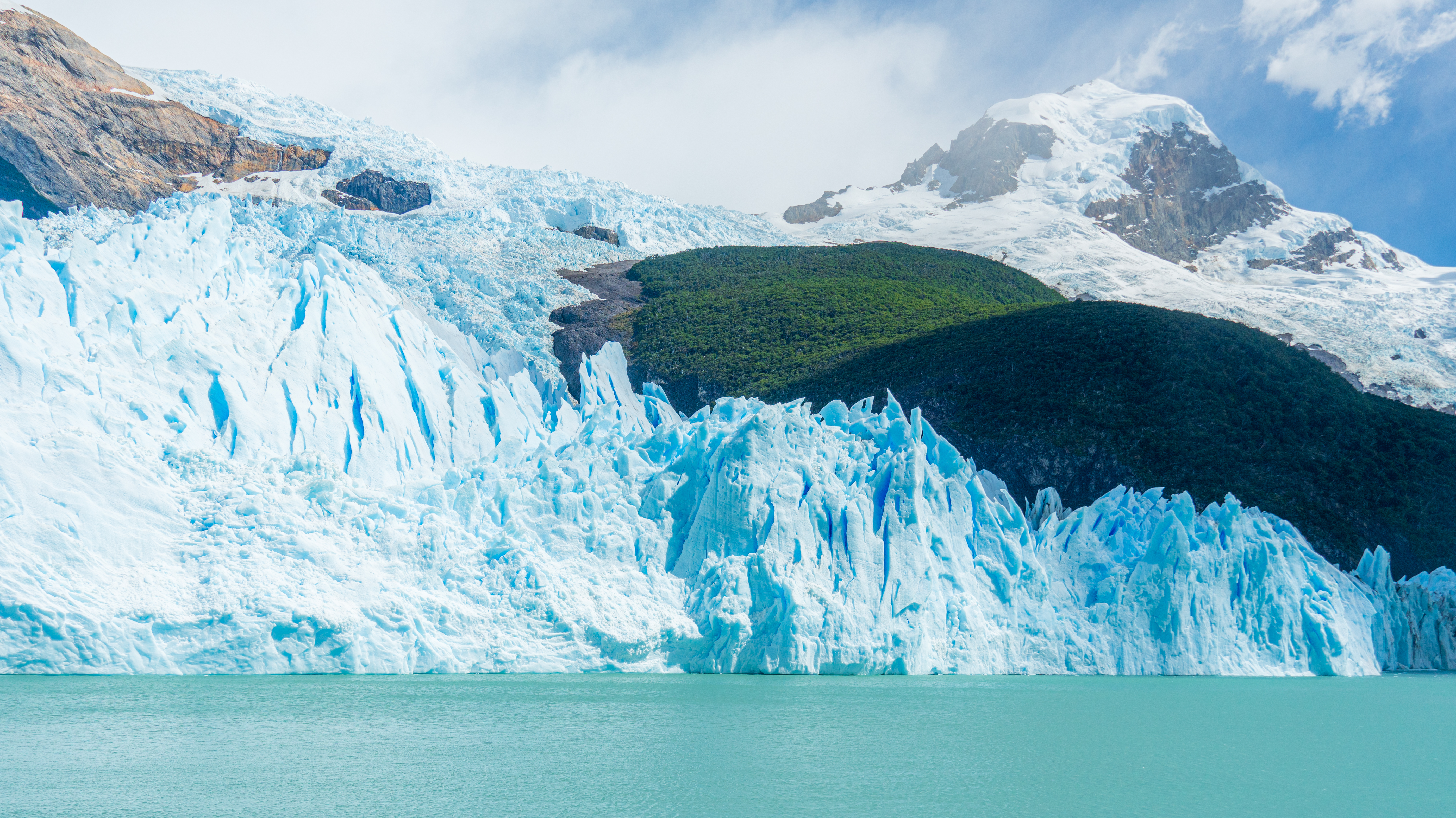
The Accessible Edge
For most visitors, Bernardo O'Higgins means the glaciers at the head of Última Esperanza Sound, reachable on day trips from Puerto Natales. The Balmaceda and Serrano glaciers offer a taste of the ice without the expedition logistics. Tour boats motor up the sound past forested islands and sheer rock walls, depositing passengers at a dock where a short forest walk leads to Serrano's blue-white face.
Mount Balmaceda rises above it all, 2,035 meters of rock and ice, its glaciers gleaming in the uncertain Patagonian light. The journey back to Puerto Natales can include a stop at an estancia for a traditional lamb asado - a surreal transition from primordial ice to pastoral tradition. For many travelers, this glimpse of the park's edge is all they'll ever see. The interior remains hidden, mythical, almost entirely unexplored.
Puerto Edén
In the middle of the channels, accessible only by the Navimag ferry or passing expedition ships, sits Puerto Edén - population 200, falling. This is one of the most isolated settlements in Chile, a scattering of wooden houses on Wellington Island where the last descendants of the Kawésqar people live alongside Chilean settlers. There is one satellite phone, functional for three hours a day. There is one small store. There is rain, almost constantly.
The Kawésqar once paddled throughout these channels, living from the sea, moving constantly in bark canoes. Disease and displacement reduced them to a handful of families. A few elders still speak the language. The younger generations face the choice facing all remote communities: stay in the isolation, or leave for the connected world. Either way, Puerto Edén represents something vanishing - a way of life at the edge of possibility.
Peaks and Passes
The park's highest point is Lautaro Volcano, 3,607 meters of ice-covered rock rising from the ice field. It erupted as recently as 1959, though its remoteness meant no one was affected. Nearby, the famous peaks of Torres del Paine and Los Glaciares parks - Fitz Roy, Cerro Torre, the Torres themselves - line the park's eastern boundary, technically within Argentina but visible from the Chilean side.
The summits lower as you move south but remain spectacular: Mount Balmaceda, Cerro Riso Patrón, ranges that have barely been explored let alone climbed. The fjords cut deep into these mountains, channels that can take days to navigate even by motorboat. What lies at the heads of these fjords - hidden glaciers, unnamed waterfalls, rock walls that have never felt a human touch - remains largely unknown.
The Real Expedition
Serious exploration of Bernardo O'Higgins requires expedition-level planning: chartered boats, weeks of supplies, satellite communication equipment, rescue contingencies. A few kayaking expeditions have threaded through the channels. A few mountaineering teams have climbed the peaks. The three-day Navimag ferry from Puerto Natales to Puerto Montt offers glimpses of the park's western edge - glaciers calving in the distance, dolphins riding the bow wave, mountains disappearing into cloud.
But the heart of the park remains essentially untouched. Climate scientists venture in to study the ice field's shrinkage. Occasionally a glacier vanishes - in 2007, an entire glacial lake within the park drained overnight, leaving a 30-meter crater. These events happen without witnesses. This is land that exists on its own terms, indifferent to human schedules, waiting for no one.
From the Air
Located at 50.0°S, 74.0°W, Bernardo O'Higgins is Chile's largest national park (35,259 km²). The Southern Patagonian Ice Field dominates the eastern portion - visible from altitude as a vast white expanse. Key landmarks: Pío XI Glacier, the largest in the Southern Hemisphere outside Antarctica, descending into Eyre Fjord; Mount Balmaceda (2,035m) near the park's accessible southern edge; Lautaro Volcano (3,607m) on the ice field. No airports within the park - access is by boat from Puerto Natales or Puerto Montt, or helicopter. Puerto Edén (population 200) is visible as a tiny settlement on Wellington Island, midway along the Navimag ferry route. The western coast is a maze of fjords, channels, and islands. Torres del Paine and Los Glaciares (Argentina) border the east. Expect severe weather - rain, wind, low cloud, limited visibility. The park is essentially roadless; only the southern glaciers near Puerto Natales are regularly visited.