Bhaja Caves
A stone carving, barely two feet wide, changed what scholars thought they knew about Indian music. Chiseled into rock around 200 BCE at the Bhaja Caves, it depicts a woman playing a tabla while another dances beside her. For centuries, historians had assumed the tabla arrived in India from Turko-Arab sources. This single image, carved by anonymous Buddhist artisans on a hillside 400 feet above a village in the Western Ghats, pushed the instrument's Indian origins back by more than a millennium. The caves themselves sit on an ancient trade route that once connected the Arabian Sea coast to the interior of the Deccan Plateau, a corridor that carried merchants, monks, and ideas between northern and southern India. Twenty-two chambers carved directly from living rock, the Bhaja Caves are among the oldest surviving examples of Indian rock-cut architecture.
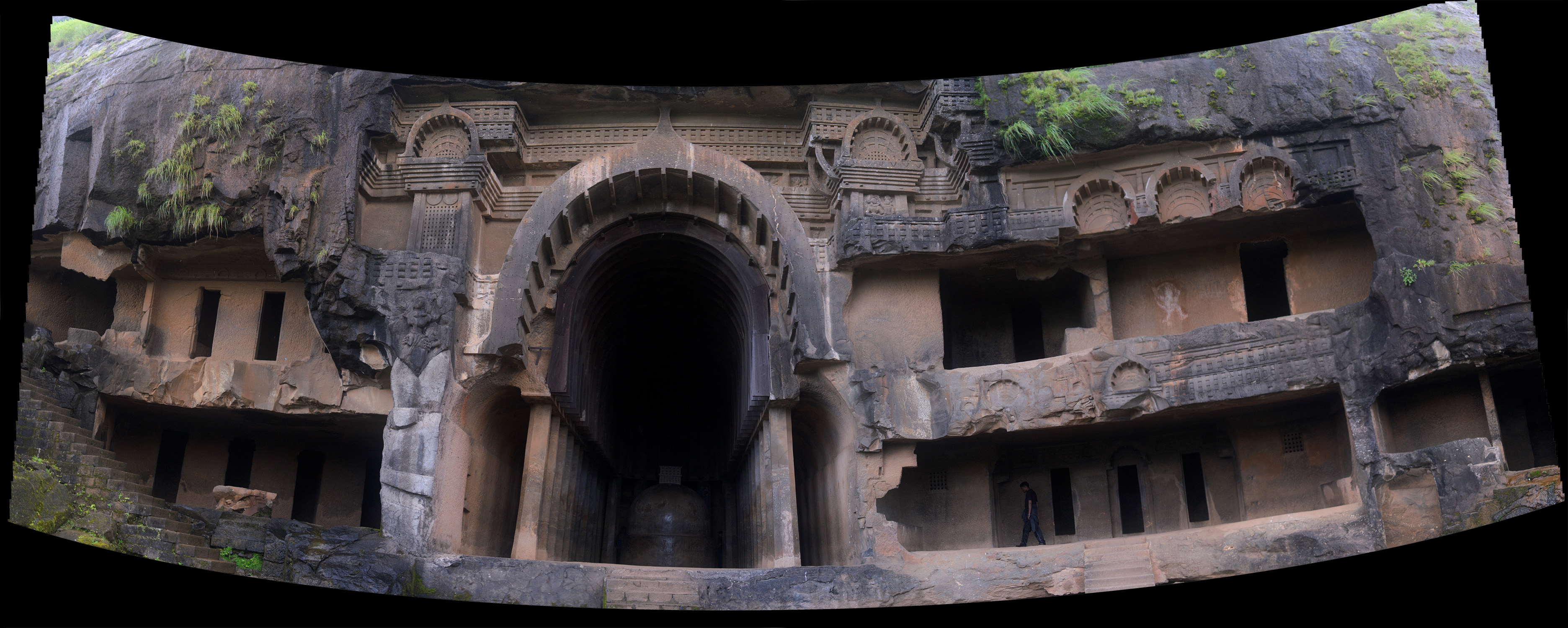
The Great Prayer Hall
The centerpiece of Bhaja is its chaityagriha, a prayer hall the Archaeological Survey of India considers one of the earliest of its kind. Its entrance is a grand horseshoe arch open to the elements, a design that hints at wooden originals long since rotted away. Inside, the hall stretches 59 feet deep and nearly 27 feet wide, its ceiling curving overhead in a barrel vault. Twenty-seven octagonal columns, each standing over 11 feet tall, separate the nave from a narrow aisle that circles behind a solid stone stupa at the far end. Worshippers would have walked this circumambulation path in ritual procession, their footsteps echoing off stone that still bears chisel marks from the 2nd century BCE. A wooden beam near the entrance carries inscriptions dating to that same era, physical proof that these caves have sheltered prayer for at least 2,200 years. At the entrance to Cave 19, stone guardians Surya and Indra flank the doorway, their forms carved in the 1st century BCE with a confidence that suggests a mature artistic tradition.
Monks in Stone
Outside the main prayer hall, fourteen stupas stand in an irregular cluster, five sheltered within a carved excavation and nine exposed to the monsoon air. These are memorial monuments for monks who lived and died at Bhaja, each one a small dome of carefully shaped stone. Inscriptions preserve three names: Ampinika, Dhammagiri, and Sanghdina, all bearing the honorary title Thera, a mark of seniority in early Buddhist monastic life. Two of the stupas retain relic boxes on their upper surfaces, containers that once held the physical remains of their honored dead. A cistern inscription elsewhere in the complex records the name of a later donor, Maharathi Kosikiputa Vihnudata, from the 2nd century CE, evidence that patronage continued for centuries after the caves were first carved. The monks who chose this hillside knew what they were doing. The location commanded the trade route below, ensuring a steady flow of merchants whose donations sustained the monastery.
A Crossroads Above the Plateau
Bhaja did not exist in isolation. Within nine kilometers to the east lie the Bedse Caves. The Karla Caves, architecturally similar and roughly contemporary, sit nearby. Patan Buddhist Cave and the Nasik Caves extend the network further. Together, these sites formed a constellation of monastic communities along the Western Ghats escarpment, each positioned to intercept the trade flowing between the Konkan coast and the Deccan interior. The route mattered because it was one of the few passages through the mountain barrier that divides western India. Merchants hauling goods from Arabian Sea ports to the cities of the plateau would have passed directly below these cave monasteries, and the monks depended on their generosity. In return, the monasteries offered shelter, spiritual services, and the social legitimacy that came with religious patronage. It was a symbiosis carved, quite literally, into the mountainside.
Water, Stone, and Monsoon
Near the last cave in the complex, a seasonal waterfall drops into a small pool at the base of the cliff. During the monsoon, when rain hammers the Western Ghats from June through September, this cascade transforms the site. Water sheets across the rock face, filling cisterns the monks carved to collect it, and the humid air thickens with the smell of wet basalt. The caves were designed for this climate. Their deep overhangs shelter interiors from driving rain, while the rock itself stays cool during the hot months preceding the monsoon. The Buddha images inside the chaityagriha, the mythological reliefs, the seven floral symbols of the Buddha carved into the pillar of Cave IX with its representations of buds, leaves, and fans, all of these were created by artisans working in a landscape shaped by extremes of wet and dry. The stone they carved is the same Deccan basalt that makes up the Western Ghats themselves, volcanic rock laid down millions of years ago and now hollowed into spaces for contemplation.
From the Air
Located at 18.73N, 73.48E in the Western Ghats, approximately 50 km southeast of Mumbai-Pune corridor. The caves sit 400 feet above Bhaja village on a steep hillside. Pune Airport (VAPO) is roughly 65 km to the east-southeast. Mumbai's Chhatrapati Shivaji International Airport (VABB) lies approximately 120 km to the northwest. From altitude, look for the escarpment line of the Western Ghats running north-south, with the Mumbai-Pune Expressway cutting through the passes. The Karla Caves and Bedse Caves are visible nearby along the same ridge system. Best viewed at 3,000-5,000 feet in clear conditions; monsoon season (June-September) may bring low clouds and reduced visibility along the Ghats.