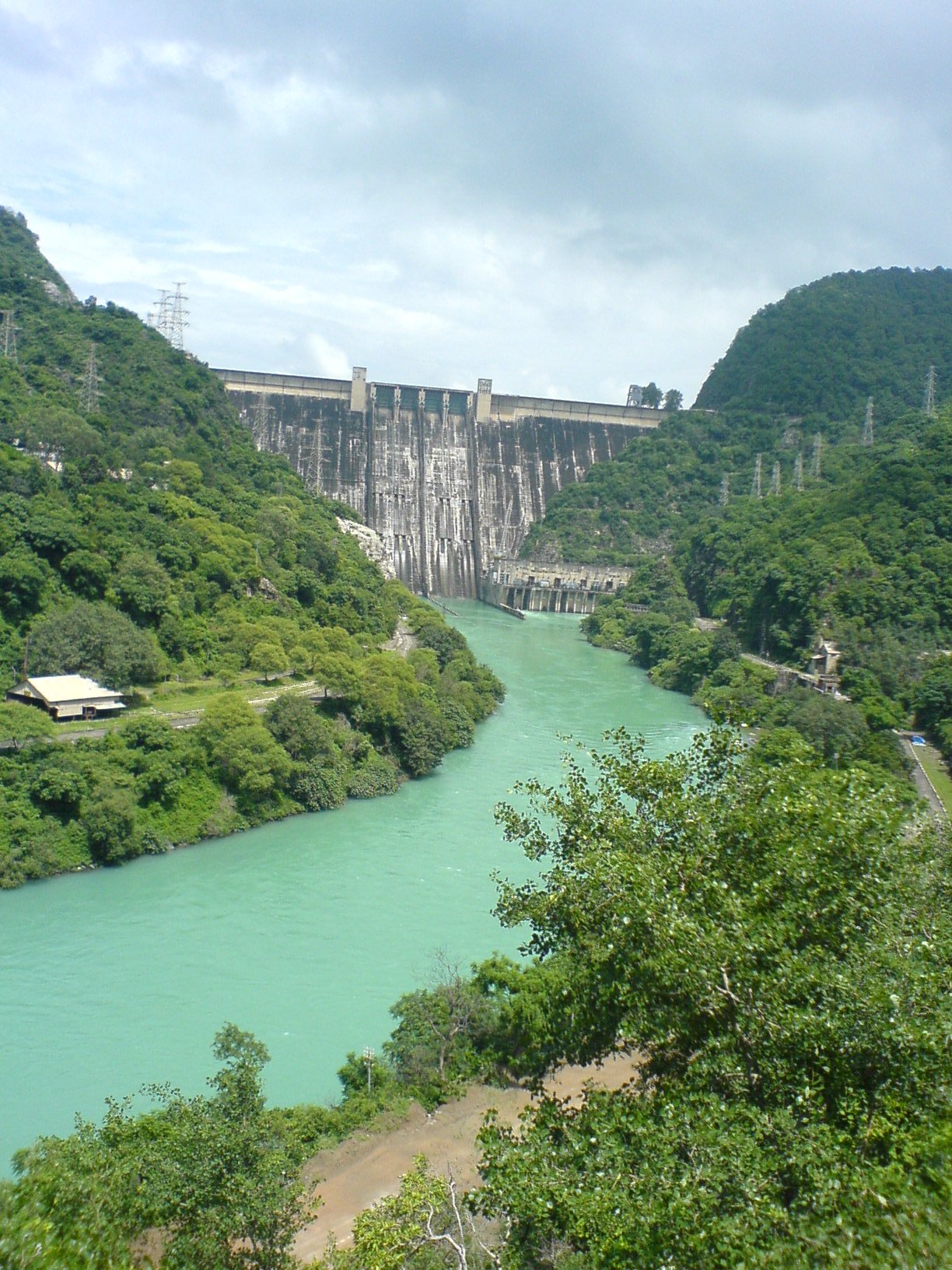
Bhakra Dam
Jawaharlal Nehru poured the first bucket of concrete into the dry riverbed of the Sutlej on November 17, 1955, and called the rising wall of concrete a gift to the people of India. He was not exaggerating. At 226 meters, Bhakra Dam would become the second tallest dam in Asia, a structure so vast that its reservoir -- Gobind Sagar -- stretches 90 kilometers through the Himalayan foothills and holds 9.34 billion cubic meters of water. For a newly independent nation still finding its footing, Bhakra was more than engineering. It was a declaration that India could build on a scale the world would notice.
A Dream Older Than Independence
The idea predates the nation itself. In 1923, Sir Chhotu Ram, a Punjab Council member widely regarded as the father of Bhakra Dam, first envisioned harnessing the Sutlej where it carved through a narrow gorge between the hills of Naina Devi and Ramgarh. The agreement to build came in November 1944, signed between Chhotu Ram and the Raja of Bilaspur, with the project plan finalized on January 8, 1945. Preliminary work began in 1946, and full construction started in 1948 -- just a year after independence. The timing was no coincidence. Bhakra belonged to Nehru's vision of "temples of modern India," the great dams and factories that would lift the country from colonial poverty. But temples need builders, and Bhakra's construction was an international affair: American engineer Harvey Slocum brought workers from the Bull Shoals Dam project in Arkansas, and a small American township rose near the construction site. When funding nearly collapsed, contractor Sir Sobha Singh arrived with his own money, keeping the project alive.
Concrete Between Two Hills
The dam sits where the Sutlej once surged through a gorge near the village of Bhakra in Bilaspur district, Himachal Pradesh. That village no longer exists -- it lies beneath Gobind Sagar, the third largest reservoir in India by storage capacity. The dam's dimensions are staggering: 518 meters long at the road surface, 9.1 meters wide, and those 226 meters of sheer concrete height dropping into the gorge below. Ten power generators split between two powerhouses produce a combined 1,325 megawatts of electricity. The left powerhouse runs on turbines originally supplied by Hitachi of Japan; the right side was equipped by the Soviet Union. Both have since been upgraded, a Cold War relic where Japanese and Russian engineering sit side by side, humming in parallel. Downstream, the Bhakra Canal irrigates 10 million acres of farmland across Punjab, Haryana, and Rajasthan -- an area roughly the size of Switzerland.
The Villages Beneath the Water
Progress demanded a price, and approximately 371 villages paid it. When Gobind Sagar filled, it swallowed communities across Bilaspur district, displacing a population whose resettlement remains incomplete more than sixty years later. The original village of Bhakra, the dam's namesake, is among the submerged. For the families who lost ancestral land to the rising water, Nehru's gift carried a different weight. The reservoir that powers turbines and feeds canals sits atop the foundations of homes, temples, and fields that people had worked for generations. It is a tension common to great infrastructure projects worldwide, but at Bhakra the scale of displacement and the decades-long delay in full resettlement give it particular gravity.
The Free Train Nobody Knows About
Among Bhakra's lesser-known features is a narrow-gauge railway connecting Bhakra Dam to Nangal Dam, 10 kilometers downstream. Operated by the Bhakra Beas Management Board, this line has eight stations and charges no fare at all -- it is the only operational railway in India where travel is completely free. The train runs along a route reminiscent of the Darjeeling Himalayan Railway, threading through the landscape the dam created. Visitors, however, cannot approach Bhakra Dam itself; security restrictions have banned public access to the dam structure. The reservoir remains open, and Gobind Sagar has become home to commercial fishing operations, including populations of the endangered Mahseer. What was built as a monument to national ambition has settled into something quieter: a working landscape where electricity generation, irrigation, fishing, and a free railway line coexist along the Sutlej's reengineered banks.
From the Air
Bhakra Dam is located at 31.41N, 76.43E in the Himalayan foothills of Himachal Pradesh. The 90 km long Gobind Sagar reservoir is a prominent water feature visible from altitude. Recommended viewing at 8,000-10,000 ft AGL. The nearest airport is Chandigarh (VICG), approximately 100 km to the south. The terrain is mountainous with elevations rising sharply to the north. Be aware of variable mountain weather conditions and restricted airspace in the region.