Bisti Badlands: New Mexico's Alien Landscape
The Bisti/De-Na-Zin Wilderness doesn't want to be visited. No marked trails cross the 45,000 acres of badlands. No signs point to the most spectacular formations. No water flows anywhere. The terrain is a maze of eroded mudstone and sandstone, where hoodoos rise like stone mushrooms, petrified logs lie scattered across the desert, and the landscape changes so dramatically that landmarks vanish around corners. The Navajo called it 'Bisti' - place of the shale hills. Photographers call it one of the most otherworldly landscapes in North America. Unprepared hikers call search and rescue. The Bisti rewards those who come equipped to navigate its trackless wastes; it punishes everyone else.
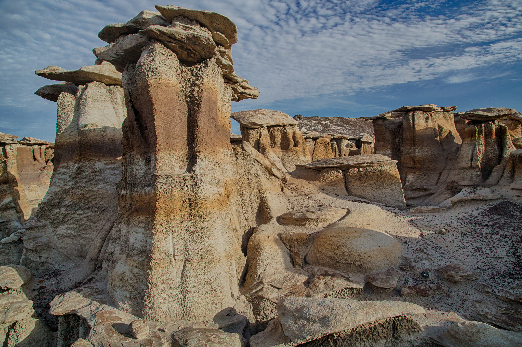
The Geology
The Bisti formed from sediments deposited 70-75 million years ago, when the region was a coastal swamp near an inland sea. Layers of shale, mudstone, sandstone, and coal accumulated, along with the remains of dinosaurs and plants that would become fossils and petrified wood. Uplift exposed the sediments to erosion. The differential hardness of the layers created hoodoos - soft rock bases capped by harder material, eroding into mushroom shapes, balanced rocks, and forms that suggest imagination run wild. The formations continue to erode; today's landscape is a snapshot in an ongoing process.
The Navigation
There are no trails in the Bisti. Visitors enter at a parking area and simply walk into the wilderness. Navigation requires GPS, compass skills, and constant attention - the terrain repeats similar features that create false recognition, and washes run in unexpected directions. The most photographed formations (known by informal names like 'the Cracked Eggs' and 'the Wings') require local knowledge or GPS coordinates to find. Cell coverage is nonexistent. Getting lost is easy; people do it regularly. The wilderness is genuine wilderness, administered by the BLM with minimal infrastructure.
The Fossils
The Bisti is rich with fossils and petrified wood - the remains of the Cretaceous swamp preserved in the eroding sediments. Dinosaur bones have been excavated here. Petrified logs, some several feet in diameter, lie exposed on the surface. Taking fossils or petrified wood is illegal; the wilderness is protected specifically to preserve these resources. The formations themselves are fragile - touching or climbing on hoodoos accelerates erosion. The landscape asks to be photographed and left alone, viewed and not collected, documented without being diminished.
The Experience
Hiking the Bisti feels like exploration. Without trails, every route is original; without signs, every discovery feels personal. The landscape shifts from rolling badlands to dense hoodoo forests to petrified wood fields to mushroom rock galleries. Colors range from gray to purple to yellow to banded combinations. The silence is complete; human sounds feel intrusive. The experience is simultaneously peaceful and slightly anxious - the beauty is extraordinary, but the knowledge that rescue is very far away sharpens attention. This is not recreational hiking; it's wilderness travel.
Visiting Bisti/De-Na-Zin
The Bisti/De-Na-Zin Wilderness is located in northwestern New Mexico, roughly 40 miles south of Farmington. Two main access points serve the area - Bisti Access and De-Na-Zin Access - connected by dirt roads that become impassable when wet. No permits required but no facilities exist; bring all water (minimum one gallon per person per day). Navigation requires GPS; download tracks for specific formations before arrival. Cell coverage is nonexistent. Never hike alone. Best light for photography occurs early morning and late afternoon; midday flattens the formations. Farmington has lodging and services. Visit spring or fall; summer temperatures can exceed 100°F with no shade available.
From the Air
Located at 36.27°N, 108.23°W in northwestern New Mexico's San Juan Basin. From altitude, the Bisti/De-Na-Zin Wilderness appears as an area of eroded badlands - gray and brown terrain dissected by countless drainages, distinct from the surrounding mesas and agricultural land. The formations are not visible from cruising altitude, but the general character of the terrain is apparent: badlands topography, minimal vegetation, no visible development. Farmington lies to the north. The Navajo Nation surrounds the wilderness on three sides. The region's energy development - oil and gas infrastructure - is visible nearby, emphasizing the wilderness area's protected status. The specific hoodoos and formations exist at ground level, invisible from above.